- Anah
-
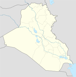
Anah The location of Anah within Iraq Coordinates: 34°22′20″N 41°59′15″E / 34.37222°N 41.9875°ECoordinates: 34°22′20″N 41°59′15″E / 34.37222°N 41.9875°E Country  Iraq
IraqProvince Al-Anbar Elevation 34 m (112 ft) Population (2003)[1] - Total 37,211 - This article is about the Iraqi town of Anah. For the district, see Anah (district), and for the character in the Book of Book of Genesis, see List of minor Biblical figures: Anah.
Anah, or Ana, is an Iraqi town on the Euphrates river, approximately mid-way between the Gulf of Alexandretta and the Persian Gulf.
Contents
Etymology
It is called Hanat in a Babylonian letter, (about 2200 BC), a-na-at by the scribes of Tukulti-Ninurta (885 BC), and An-at by the scribe of Assur-nasir-pal (879 B.C.), Anatho (Isidore Charax), Anatha (Ammianus Marcellinus) by Greek and Latin writers in the early Christian centuries, Ana (sometimes, as if plural, Anat) by Arabic writers. The name has been connected with that of the deity Anat.
Background
Whilst Anah has thus retained its name for forty-one centuries the site is variously described. Most early writers concur in placing it on an island; so Tukulti-Ninurta II, Assur-nasir-pal, Isidore, Ammianus Marcellinus, Ibn Serapion, al-Istakri, Abulfeda and al-Karamani. Ammianus[2] calls it a munimentum, Theophylactus Simocatta[3] to 'Anathon frourion, Zosimus[4] a frourion, opp. Fathusai, which may be the Beth(th) ina of Ptolemy (v. 19).[5] Leonhart Rauwolff, in AD 1574, found it "divided ... into two towns," the one "Turkish," "so surrounded by the river, that you cannot go into it but by boats," the other, much larger, on the Arabian side of the river.[6]
History
This southernmost town of Mesopotamia proper (Jazira) must have shared the chequered history of that land. Of Anah's fortunes under the early Babylonian empire the records have not yet been unearthed; but in a letter dating from the third millennium BC, six men of Hanat (Ha-na-atK1) are mentioned in a statement as to certain disturbances which had occurred in the sphere of the Babylonian Resident of Suhi, which would include the district of Anah.
How Anah fared at the hands of the Mitanni and others is unknown. The suggestion that Amenophis (Amenhotep) I. (16th century BC) refers to it is improbable; but we seem to be justified in holding Anah to be the town "in the middle of the Euphrates" opposite (ina put) to which Assur-nasir-pal halted in his campaign of 879 BC. The supposed reference to Anah in the speech put into the mouth of Sennacherib's messengers to Hezekiah (2 Kings xix. 13, Is. xxxvii. 13) is exceedingly improbable. The town may be mentioned, however, in four 7th century documents edited by Claude Hermann Walter Johns.[7]
It was at Anah that the emperor Julian met the first opposition on his disastrous expedition against Persia (363), when he got possession of the place and transported the people; and there that Ziyad and Shureih with the advanced guard of Ali's army were refused passage across the Euphrates (36/657) to join Ali in Mesopotamia (Tabari i. 3261).
Later Anah was the place of exile of the caliph Qaim (al-qaim bi-amr-illah) when Basisiri was in power (450/1058.) In the 14th century Anah was the seat of a Catholicos, primate of the Persians (Marin Sanuto). In 1610 Pietro Della Valle found a Scot, George Strachan, resident at Anah (to study Arabic) as physician to the amir (i. 671-681). In 1835 the steamer "Tigris" of the English Euphrates expedition went down in a hurricane just above Anah, near where Julian's force had suffered from a similar storm. Della Valle described Anah as the chief Arab town on the Euphrates, an importance which it owes to its position on one of the routes from the west to Baghdad; Texeira said that the power of its amir extended to Palmyra (early 17th century); but Olivier found the ruling prince with only twenty-five men in his service, the town becoming more depopulated every day from lack of protection from the Arabs of the desert.
Modern Anah
Modern Anah lies from west to east on the right bank along a bend of the river just before it turns south towards Hit, and presents an attractive appearance. It extends, chiefly as a single street, for several miles along a narrow strip of land between the river and a ridge of rocky hills. The houses are separated from one another by fruit gardens. Anah marks the boundary between the olive (north) and the date (south).
Arab poets celebrated its wine,[8] and Mustaufi (8/14th century) tells of the fame of its palm-groves. In the river, facing the town, is a succession of equally productive islands. The most easterly contains the ruins of the old castle, whilst the remains of the ancient Anatho extend from this island for about 2 miles down the left bank. Coarse cloth is almost the only manufacture.
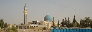
One of 'Anah's prized possessions was an ancient minaret. Dr. Alastair Northedge, a British archaeologist who wrote a book about findings in 'Anah, wrote that the minaret is 'commonly attributed to the Uqaylid (dynasty) and the 5th/11th century (AH/AD), though ... more probably of the 6th/12th century [AH/AD]. It was situated on the island at 'Anah and belonged to ... the congregational mosque.
When the valley was flooded by the Haditha Dam at Haditha in 1984-85, the Iraqi State Board of Antiquities cut it into sections, and removed it to the new 'Anah where it was re-erected at the end of the 1980s.' Before the 2003 invasion of Iraq Dr. Muayad Said described the structure before the filling of the reservoir: 'It has an octagonal body enhanced by alcoves, some of which are blind. ... Conservation work on the building was undertaken in 1935 and again in 1963 and 1964, and today it stands 28 metres high and fully restored.'
References
- ^ http://www.iraqcoalition.org/regions/south-central/provinces/english/anbar.html
- ^ lib. 24, c. 2.
- ^ iv. 10, v. 1, 2.
- ^ iii. 14.
- ^ Steph. Byz. (sub Turos) says that Arrian calls Anatha Turos.
- ^ Texeira (1610) says that "Anna" lay on both banks of the river, and so Della Valle (i. 671).
- ^ Ass. Deeds and Doc. nos. 23, 168, 228, 385. The characters used are DIS TU, which may mean Ana-tu.
- ^ Yuqut, iii. 593f.
Further reading
In addition to the authorities cited above may be mentioned: G. A. Olivier, Voyage dans l'empire othoman, etc., iii. 450-459 (1807); Carl Ritter, Erdkunde von Asien, vii. b., pp. 716– 726 (1844); William Francis Ainsworth, Euphrates Expedition, i. 401-418 (1888).
- Attribution
 This article incorporates text from a publication now in the public domain: Chisholm, Hugh, ed (1911). Encyclopædia Britannica (11th ed.). Cambridge University Press.
Cities of Al Anbar in Iraq Ar Ramadi · Al Fallujah · Al Khaldiya · Hit · Haditha · Al Haqlaniyah · Habbaniyah · Ar Rutba · Husaybah · Nukhayb · Anah · Rawah · Al Karmah · Kabisa · Al Amiriyah · Al Waleed · Akashat · Tarbil · Khan al Baghdadi · Barwanah · Al Rahaliyah · Saqlawiyah · Husaibah Al Sharqiah · Al Karblah · Al Ubaidi · Al Qaim
Districts of Iraq and capitals Al Anbar Governorate Al Muthanna Governorate Al-Khidhir District (Al-Khidhir) • Al-Rumaitha District (Al-Rumaitha) • Al-Salman District (Al-Salman) • Al-Samawa District (Samawa)Al-Qādisiyyah Governorate Afaq District (Afaq) • Al-Shamiya District (Al-Shamiya) • Diwaniya District (Diwaniya) • Hamza District (Hamza)Babil Governorate Al-Mahawil District (Al-Mahawil) • Al-Musayab District (Al-Musayab) • Hashimiya District (Hashimiya) • Hilla District (Hilla)Baghdad Governorate Basra Governorate Abu Al-Khaseeb District (Abu Al-Khaseeb) • Al-Midaina District (Al-Midaina) • Al-Qurna District (Al-Qurna) • Al-Zubair District (Al-Zubair) •
Basrah District (Basrah) • al-Faw District (al-Faw) • Shatt Al-Arab District (Shatt Al-Arab)Dhi Qar Governorate Al-Chibayish District (Al-Chibayish) • Al-Rifa'i District (Al-Rifa'i) • Al-Shatra District (Al-Shatra) • Nassriya District (Nassriya) • Suq Al-Shoyokh District (Suq Al-Shoyokh)Diyala Governorate Dohuk Governorate Amadiya District (Amadiya) • Dohuk District (Dohuk)• Sumel District (Sumel) • Zakho District (Zakho)Arbil Governorate Makhmur District (Makhmur) • Arbil • Koisanjaq District (Koisanja) • Shaqlawa District (Shaqlawa)• Soran District • Mergasur District • Choman DistrictKarbala Governorate Ain Al-Tamur District (Ain Al-Tamur) • Al-Hindiya District (Al-Hindiya) • Kerbala District (Kerbala)Kirkuk Governorate Maysan Governorate Ali Al-Gharbi District (Ali Al-Gharbi) • Al-Kahla District (Al-Kahla) • Al-Maimouna District (Al-Maimouna) • Al-Mejar Al-Kabi District (Al-Mejar Al-Kabi) • Amara District (Amarah) • Qal'at Saleh District (Qal'at Saleh)Najaf Governorate Ninawa Governorate Aqrah District (Aqrah) • Al-Ba'aj District (Al-Ba'aj) • Al-Hamdaniya District (Bakhdida) • Hatra District (Hatra) •Mosul District (Mosul) • Shekhan District (Ain Sifni) • Sinjar District (Sinjar) • Tel Afar District (Tel Afar) • Tel Keppe District (Tel Keppe)Salah ad Din Governorate Al-Daur District (Al-Daur) • Al-Shirqat District (Al-Shirqat) • Baiji District (Baiji) • Balad District (Balad) • Samarra District (Samarra) • Tikrit District (Tikrit) • Tooz District (Tooz)Sulaymaniyah Governorate Chamchamal District (Chamchamal) • Darbandokeh District (Darbandokeh) • Dokan District (Dokan) • Halabja District (Halabja) • Kalar District (Kalar) • Penjwin District (Penjwin) • Pshdar District (Pshdar) • Ranya District (Ranya) • Sharbazher District (Sharbazher) • Sulaymaniya District (Sulaymaniya)Wasit Governorate Al-Hai District (Al-Hai) • Al-Na'maniya District (Al-Na'maniya) • Al-Suwaira District (Al-Suwaira) • Badra District (Badra) • Kut District (Kut)Categories:- Populated places in Al Anbar Governorate
- Populated places on the Euphrates River
- District capitals of Iraq
Wikimedia Foundation. 2010.


