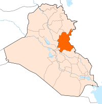
- Diyala Governorate
-
Diyala Governorate
ديالى
Diyala Province— Province — Coordinates: 33°53′N 45°4′E / 33.883°N 45.067°ECoordinates: 33°53′N 45°4′E / 33.883°N 45.067°E Country  Iraq
IraqCapital Baqubah Area – Total 17,685 km2 (6,828.2 sq mi) Population (2003) – Total 1,224,000 Diyala Governorate (Arabic: ديالى Diyālā) (or Diyala Province) is a province in eastern Iraq.
Contents
Provincial Government
- Governor: Abdul-Nasir Al-Muntasir Billah Al-Mahdawi[1]
- Deputy Governor: Furat Muhammad Abed Al-Tamimi [2]
- Provincial Council Chairman (PCC): Talib Muhammad Hasan [3]
Geography
Diyala Governorate extends to the northeast of Baghdad as far as the Iranian border. Its capital is Baqubah. It covers an area of 17,685 square kilometres (6,828 sq mi).
A large portion of the province is drained by the Diyala River, a major tributary of the Tigris. Because of its proximity to two major sources of water, Diyala's main industry is agriculture, primarily dates grown in large groves. The province also contains one of the largest olive groves in the Middle East.[4] It is also recognized as the orange capital of the Middle East. The Hamrin Mountains pass through the governorate.
Population
In 2003, it had an estimated population of some 1,224,000 people. Iraqi Arabs comprise about 82 percent of the governorate, Iraqi Kurds about 16 percent (predominantly in the Khanaquin and Kifri Districts), and Iraqi Turkmen about 2 percent.[5] Around 75% of the population live in the major cities: Baqubah, Muqdadiyah and Khanaqin.[6]
The population as estimated in 2003 is as follows:
District Baqubah Al-Muqdadiya Khanaqin Al Khalis Kifri Balad Ruz Total Population 467,895 198,583 160,379 255,889 42,010 99,601 1,224,358 Districts
- Al Khalis District (Al Khalis)
- Al-Muqdadiya District (Al-Muqdadiya)
- Balad Ruz District (Balad Ruz)
- Ba'quba District (Ba'quba)
- Khanaqin District (Khanaqin)
- Kifri District (Kifri)
Cities and towns and villages
- Baqubah (provincial capital)
- Muqdadiyah
- Hebheb
- Khanaqin
- Balad Ruz
- Al Khalis
- Bani sa'ad
- Jalula
- As-Sadiyah
- Ashraf City
- Dwelah
- Kingirban[7]
- Marfu Village
- Village of Nye
- Udame
- Kingirban
- Al Mansouryah
- Kan’aan
- Al Wajehiya
- Al Muntheriya
- Abu Saydah
- Buhriz
- Mandali
Infrastructure
The Diyala Province also boasts the Diyala Media Center which has one of the Middle East's tallest radio and television antennas at 349 metres (1,047 ft). The Diyala Media Center was built under contract by a Japanese architectural firm in 1989. It is one of Iraq's few independent radio and television stations that offer local television and radio news coverage as well as rebroadcasting state-run television.
Civil unrest
There is evidence that Al-Qaeda in Iraq has recently moved its base of operations from Anbar province to Diyala. During late 2006 Baqubah and much of the Diyala province were reported to have come under Sunni insurgent control.[8] This insurgent control is reported to have continued through 2007 and into early 2008.[9]
On May 11, 2007, Army Maj. Gen. Benjamin Mixon, commander of the Multination Division North said he needed more troops in order to contain the current level of violence in the Diyala province, this coming in the recent wake of a troop "surge", involuntary recalls by the U.S. military, and the public debate about the level of commitment from the U.S. government.[10] By mid-2007 the Islamic State of Iraq, already holding Baqubah and most of the province under its control, declared its capital to be Baqubah. There is already strong evidence the Islamic State of Iraq has moved most of its command and control operations to Diyala.[citation needed]
In June 2007, US forces launched Operation Arrowhead Ripper with night air assaults in Baquba. By August 19, Baquba was largely secured, although some insurgent presence remained in the city and surrounding areas.[citation needed] Fighting continued in the Diyala River valley but by the beginning of October, US and Iraqi forces held most of the province while the insurgents were in retreat to the north and west. Diyala is still a contested province. On October 27 the Islamic State of Iraq attacked a police base in Baqubah, killing 28 Iraqi policemen and police recruits, showing that insurgent cells still remain in the province.[citation needed]
In January 2008 Operation Phantom Phoenix was launched in an attempt to eradicate the remaining insurgents following the Diyala province campaign between 2006 and 2007.
Mid 2008 saw many changes in Diyala province with an increased effort by U.S. Forces and a substantial Iraqi Army presence, and in the Baqubah region, Al Qaida in Iraq activity was dramatically hampered, and the Sons of Iraq program served only to further weaken Al-Qaida in Iraq.
See also
- Battle of Baqubah
- 2004 Baqubah bombing
- 15 July 2008 Baquba bombings
- 15 September 2008 Balad Ruz bombing
- 23 April 2009 Iraqi suicide attacks
- 3 March 2010 Baqubah bombings
References
- ^ [1]
- ^ [2]
- ^ [3]
- ^ Biggest Olive Groves in Middle East – in Diyala
- ^ Web
- ^ Web
- ^ "Republic of iraq (IQ): Asia/Iraq/Diyala". Tageo.com. http://www.tageo.com/index-e-iz-v-10-d-m4389473.htm. Retrieved 2007-05-28.
- ^ Engel, Richard (December 27, 2006). "Reporting under al-Qaida control". Blogging Baghdad: The Untold Story (MSNBC). http://onthescene.msnbc.com/baghdad/2006/12/reporting_under.html#posts. Retrieved 2007-05-28.
- ^ Engel, Richard (January 17, 2007). "Dangers of the Baghdad plan". Worldblog. MSNBC. http://worldblog.msnbc.msn.com/archive/2007/01/17/32969.aspx. Retrieved 2007-05-28.
- ^ "DoD Special Security Operations Briefing with Maj. Gen. Mixon from Iraq". News Transcript. U.S. Department of Defense. May 11, 2007. http://www.defenselink.mil/transcripts/transcript.aspx?transcriptid=3961. Retrieved 2007-05-28.
External links
- Iraq Inter-Agency Information & Analysis Unit Reports, Maps and Assessments of Iraq from the UN Inter-Agency Information & Analysis Unit

Sulaymaniyah Governorate 
Salah ad Din Governorate 
 Kermanshah Province, Iran
 Diyala Governorate

Baghdad Governorate
Babil GovernorateWasit Governorate  Ilam Province, Iran
Provinces of Iraq
Wikimedia Foundation. 2010.

