- Ouidah
-
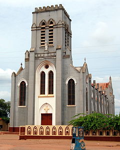
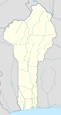
Ouidah — Commune and city — Basilica of Ouidah Location in Benin Coordinates: 6°22′N 2°05′E / 6.367°N 2.083°E Country  Benin
BeninDepartment Atlantique Department Area – Total 140.5 sq mi (364 km2) Elevation 213 ft (65 m) Population (2002) – Total 76,555 Time zone WAT (UTC+1) Ouidah (
 /ˈwiːdə/), also Whydah /ˈhwɪdə/ or Juda,[1] is a city on the Atlantic coast of Benin. The commune covers an area of 364 square kilometres and as of 2002 had a population of 76,555 people.[2]
Contents
History
In local tradition Kpase is supposed to have founded the town.[3] This probably happened towards the end of the sixteenth century.[4] The town was originally known as Glēxwé, literally 'Farmhouse', and was part of the kingdom of Xwéda.
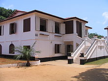
In 1727 the Kingdom of Whydah was captured by the forces of King Agaja of Dahomey.The Portuguese, English and French all constructed forts in the city to protect their interests in slaving. The Portuguese reached the town they called Ajudá in 1580 and the Portuguese Fort of São João Baptista de Ajudá, now housing a museum, dates from 1721 and remained with Portugal until 31 July 1961.
Other attractions in Ouidah include a restored mansion of Brazilian slavers the Maison du Brésil art gallery, a voodoo python temple, an early twentieth century basilica and the Sacred Forest of Kpasse, dotted with bronze statues.
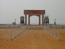
The Route des Esclaves, by which slaves were taken to the beach, has numerous statues and monuments, including the Door of No Return, a monumental arch.
The Market Center of Ouidah, which was established by Scouts more than 20 years ago, trains young people in agricultural skills, thus helping to reverse the exodus towards the cities.
Ouidah is the spiritual capital of the Vodun religion, and hosts an annual international Vodun conference.[5]
Demographics
The population evolution of Ouidah is as follows:
Year Population[6] 1979 25 459 1992 64 433 2002 77 832 2008 (estimate) 90 042 Fort of São João Baptista de Ajudá
The Fort of São João Baptista de Ajudá (in English St. John the Baptist of Ouidah Fort) is a small fortress built by the Portuguese in the city of Ouidah on the coast of Dahomey (originally Ajudá, from Hweda, on the Atlantic coast of modern Benin), reached by the Portuguese in 1580, after which it grew around the slave trade, for which the Slave Coast was already renowned. The Fort, built in land given to Portugal by the King of Dahomey, remained under Portuguese control from 1721 until 1961.
In 1680 the Portuguese governor of São Tomé and Príncipe was authorised to erect a fort. In 1721, after having been abandoned for some years, it was reconstructed and named São João Baptista de Ajudá.
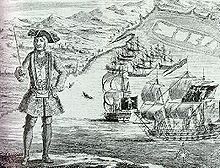 Pirate Bartholomew Roberts at Ouidah, with his ship and captured merchantmen in the background
The fort had an important impact in Benin, greatly contributing to both the Portuguese and African slave trade. Its importance is attested by the fact that the Portuguese language was the only foreign language that the Kings of Dahomey authorised. Portuguese descendants were also important in the political structure of the kingdom and some established Portuguese-Brazilian families, such as the Sousa whose descendants still exist in Benin, were powerful and abided by private law. In January 1722 the pirate Bartholomew Roberts ("Black Bart") sailed into the harbour and captured all the eleven ships at anchor there.
Following the abolition of the legal slave trade in 1807, the fort, which had before been one of the major slave ports, gradually lost its importance and although Portugal continued to claim it as one of its possessions, formal occupation and administration were abandoned on several occasions. It was only when French presence in the region started threatening Portugal’s interests that the settlement was again permanently manned. This didn't prevent the French conquest of Dahomey (1891–1894). After this, São João Baptista de Ajudá - now reduced to the territory actually within the walls of the fort - lost what remained of its importance.
The fort was reoccupied by Portugal in 1865. In this period it served as a base for a brief Portuguese attempt to create a protectorate in the Kingdom of Dahomey of which the city of Hweda (Ajudá - Ouidah) was part (1885–1887).
Until its annexation by Dahomey in 1961, São João Baptista de Ajudá was probably the smallest recognized separate modern political unit: according to the census of 1921 it had 5 inhabitants and, at the moment of the ultimatum by the Dahomey Government, it had only 2 inhabitants representing Portuguese Sovereignty who tried to burn it rather than surrendering it.
Only in 1975, after the Portuguese Estado Novo regime has been overthrown due to the Carnation Revolution at Lisbon, did the annexation of the fort by Dahomey (now renamed Benin) gain official Portuguese recognition. This was followed by the forts' restoration, which was paid for by Portugal. The fort is a small square with towers at the four corners. It comprises a church and officers' quarters. The Fort of São João Baptista de Ajudá now houses a museum.
Bruce Chatwin’s book The Viceroy of Ouidah (1980) is a fictional retelling of the life of Francisco Félix de Sousa, the Sousa family founder in Benin and that of his powerful local descendants, dealing also with the subject of slave trade with Brazil.
Notable landmarks
- Door of No Return
- Ouidah Cathedral
- Basilique de l’Immaculée Conception
World Heritage Status
This site was added to the UNESCO World Heritage Tentative List on October 31, 1996 in the Cultural category.[7]
References
- ^ Kein, Sybil, Creole, p227
- ^ "Communes of Benin". Statoids. http://www.statoids.com/ybj.html. Retrieved January 5, 2010.
- ^ Robin Law, Ouidah: The Social History of a West African Slaving 'Port', 2004, p.21
- ^ Robin Law, Ouidah: The Social History of a West African Slaving 'Port', 2004, p.24-25
- ^ "The Voodoo Day: Benin welcomes magicians from all over the world". 2004-11-01. http://english.pravda.ru/world/africa/11-01-2004/4545-voodooday-0. Retrieved 2008-08-29.
- ^ "Benin". World Gazetteer. http://world-gazetteer.com/wg.php?x=&men=gpro&lng=en&des=wg&geo=-35&srt=npan&col=abcdefghinoq&msz=1500&pt=c&va=&geo=346914209. Retrieved 2008-12-19.
- ^ La ville d'Ouidah : quartiers anciens et Route de l'Esclave - UNESCO World Heritage Centre
- WorldStatesmen- Benin not quite worked in yet
- La ville d'Ouidah : quartiers anciens et Route de l'Esclave - UNESCO World Heritage Centre
See also
- Heads of State of Benin
- Heads of Government of Benin
Coordinates: 6°22′N 2°05′E / 6.367°N 2.083°E
Alibori Department 
Atakora Department Atlantique Department Borgou Department Collines Department Donga Department Kouffo Department Littoral Department Mono Department Ouémé Department Adjarra • Adjohoun • Aguégués • Akpro-Missérété • Avrankou • Bonou • Dangbo • Porto-Novo • Sèmè-KpodjiPlateau Department Zou Department Categories:- Communes of Benin
- Populated places in Benin
- Enclaves
- Ouidah
- Portuguese forts
Wikimedia Foundation. 2010.

