- Ouinhi
-
Ouinhi — Commune and city — Location in Benin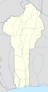
 Ouinhi
Coordinates: 7°20′N 2°27′E / 7.333°N 2.45°E Country  Benin
BeninDepartment Zou Department Area – Total 186.5 sq mi (483 km2) Population (2002) – Total 38,319 Time zone WAT (UTC+1) Ouinhi is a town, arrondissement, and commune in the Zou Department of south-western Benin. The commune covers an area of 483 square kilometres and as of 2002 had a population of 38,319 people.[1][2] It is bounded on the north-west by the commune of Zagnanado, south-west by the commune of Zogbodomey, south by the commune of Bonou and east by the commune of Adja-Ouèrè. The commune is divided into arrondisements which include Dasso, Ouinhi, and Tohu, comprising 28 villages.[3]
The arrondisements of Ouinhi and Dasso were struck hard by the 2008 Benin floods in July 2008, tearing down mud and straw homes and infrastructure and polluting rivers.[4]
References
- ^ "Ouinhi". Atlas Monographique des Communes du Benin. http://atlasbenin.africa-web.org/Zou/Ouinhi.htm. Retrieved January 5, 2010.
- ^ "Communes of Benin". Statoids. http://www.statoids.com/ybj.html. Retrieved January 5, 2010.
- ^ "Ouinhi". www.ouinhi.communedubenin.org. http://www.ouinhi.communedubenin.org/. Retrieved January 5, 2009.
- ^ "BENIN: Half million potential flood victims : WHO". IRIN, UN Office for the Coordination of Humanitarian Affairs. http://www.irinnews.org/Report.aspx?ReportId=80153. Retrieved January 5, 2010.
External links
Coordinates: 7°0′N 2°27′E / 7°N 2.45°E
Alibori Department 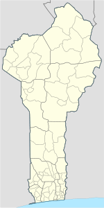
Atakora Department Atlantique Department Borgou Department Collines Department Donga Department Kouffo Department Littoral Department Mono Department Ouémé Department Adjarra • Adjohoun • Aguégués • Akpro-Missérété • Avrankou • Bonou • Dangbo • Porto-Novo • Sèmè-KpodjiPlateau Department Zou Department Abomey Agbokpa · Dètohou · Djègbè · Hounli · Sèhoun · Vidolè · Zounzounmè
Agbangnizoun Adahondjigon · Adingningon · Agbangnizoun · Kinta · Kpota · Lissazounmè · Sahé · Siwé · Tanvé · Zoungoudo
Bohicon Agongointo · Avogbana · Bohicon I · Bohicon II · Gnidjazoun · Lissèzoun · Ouassaho · Passagon · Saclo · Sodohomè
Covè Adogbé · Gounli · Houéko · Houen-Hounso · Lainta-Cogbè · Naogon · Soli · Zogba
Djidja Agondji · Agouna · Dan · Djidja · Dohouimè · Gobè · Monsourou · Mougnon · Oungbègamè · Outo · Setto · Zoukou
Ouinhi Dasso · Ouinhi · Sagon · Tohoué
Za-Kpota Allahé · Assalin · Houngomey · Kpakpamè · Kpozoun · Za-Kpota · Za-Tanta · Zèko
Zagnanado Agonli-Houégbo · Banamè · Don-Tan · Dovi · Kpédékpo · Zagnanado
Zogbodomey
Akiza · Avlamè · Cana I · Cana II · Domè · Koussoukpa · Kpokissa · Massi · Tanwé-Hessou · Zogbodomey · Zoukou Categories:
- Communes of Benin
- Arrondissements of Benin
- Populated places in the Zou Department
- Benin geography stubs


Wikimedia Foundation. 2010.