- Noosa National Park
-
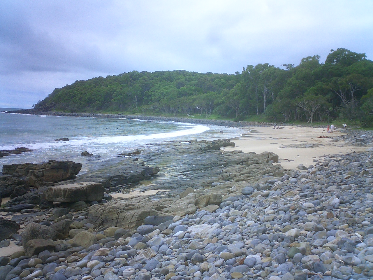
Noosa National Park A beach on the headlands coastal trail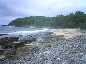
Coordinates 26°23′04″S 153°06′46″E / 26.38444°S 153.11278°ECoordinates: 26°23′04″S 153°06′46″E / 26.38444°S 153.11278°E Area 4,000 ha (15.44 sq mi) Established 1939 Visitation 1 million (in 2009) Managing authorities Queensland Parks and Wildlife Service Official site Noosa National Park Noosa National Park is a national park in Queensland, Australia, 121 km north of Brisbane. It is situated near Noosa Heads between the Pacific Ocean and the Sunshine Coasts's northern area of urban development and extends southwards, past Lake Weyba to Coolum.[1] The 4,000 hectare park is divided into four sections; Headland Section, Peregian Section, Emu Mountain Section and the East Weyba Section.[1] Noosa National Park is the most popular national park in the country, with more than 1 million visits each year.[2][3]
Several beaches in the park provide good locations for swimming.[4] These beaches are not patrolled. Swimmers should be aware of strong currents at Alexandria Bay. The southern end of Alexandria Bay is unofficially clothing optional.[1] Rockclimbing, fishing, surfing and snorkeling are other recreational activities undertaken in the park, while camping is banned.[4]
Contents
History
The early settlers of Noosa Heads set aside a reserve to protect the area in 1879.[4] The reserve officially became a national park in 1939.[1]
Advocates for the park's protection were active in the early 1960s when the Noosa Parks Association was formed at time when urban development was threatening the wilderness area.[5] A management plan for the park was released in October 1999.[6]
In 2003, an extra 300 hectares at Coolum were added to park.[7] On 27 May 2008, an elderly woman and her husband were assaulted while walking through the national park. A 26 year old man was found mentally unfit to stand trial for the attack which resulted in serious injuries.[8]
Flora
The Headlands Section of the park contains pockets of rainforest where hoop and kauri pines dominate.[1] There are also areas of open eucalypt forest, wallum heaths, pandanus palms and grasslands.[4][9] The Peregian Section is known for its wildflowers which blossom in spring, particularly the rare swamp orchid and Christmas bells.[1][9]
Fauna
A population of koalas is found in the park, as are mammal species such as the short-nosed bandicoot, common ringtail possum, brushtail possum.[4] Birds such as the Eastern Ground Parrot, Glossy Black Cockatoo, Eastern Yellow Robin, Rufous Fantail, Satin Bowerbird and Crimson Rosella are all found in the park's forests.[4] Headlands in the park are a popular place to watch migrating humpback whales.[10]
Walking tracks
An oceanway runs from the Noosa River mouth along Hastings Street town centre and then out around the Noosa National Park headlands and beaches to Sunshine Beach.
The highest point in the park is Noosa Hill. One of the walking tracks in the park leads to the top of the 147 m hill.[4] There are a total of five walking tracks with the longest being 8 km.[11] Another track leads to Hell's Gate, one of the park's headlands. This track is the most traversed trail in Queensland.[12]
See also
References
- ^ a b c d e f "About Noosa National Park". Department of Environment and Resource Management. 29 April 2010. http://www.derm.qld.gov.au/parks/noosa/about.html. Retrieved 23 September 2010.
- ^ "Noosa tourism and reserves". Department of the Environment, Water, Heritage and the Arts. 16 September 2010. http://www.environment.gov.au/parks/publications/nrs/noosa.html. Retrieved 23 September 2010.
- ^ "Noosa Parks Association is EPA partner at information centre". Media Release. Department of Environment and Resource Management. 20 January 2009. http://www.derm.qld.gov.au/media-room/2009/01/m01369.html. Retrieved 25 September 2010.
- ^ a b c d e f g Hema Maps (1997). Discover Australia's National Parks. Milsons Point, New South Wales: Random House Australia. pp. 200. ISBN 1975992472.
- ^ Gail Forrer-Arnold (27 November 2009). "DVD shows how national park saved". Noosa News (APN News & Media). http://www.noosanews.com.au/story/2009/11/27/dvd-shows-how-national-park-saved/. Retrieved 23 September 2010.
- ^ "Noosa National Park management plan". Department of Environment and Resource Management. 9 September 2010. http://www.derm.qld.gov.au/services_resources/item_details.php?item_id=200873. Retrieved 23 September 2010.
- ^ "More land for Noosa National Park". ABC News Online (Australian Broadcasting Corporation). 20 February 2003. http://www.abc.net.au/news/newsitems/200302/s788858.htm. Retrieved 23 September 2010.
- ^ Tony Keim (3 September 2010). "Judge finds Benjamin Anton Sorensen, 26, of Toowoomba, mentally unfit to stand trial for Noosa National Park attacks". The Courier-Mail (Queensland Newspapers). http://www.couriermail.com.au/news/judge-finds-benjamin-anton-sorensen-26-of-toowoomba-mentally-unfit-to-stand-trial-for-noosa-national-park-attacks/story-e6freon6-1225913654072. Retrieved 23 September 2010.
- ^ a b Explore Queensland's National Parks. Prahran, Victoria: Explore Australia Publishing. 2008. pp. 49. ISBN 9781741172454.
- ^ Phil Hammond (29 June 2007). "Whales' northern exposure". The Courier-Mail (Queensland Newspapers). http://www.couriermail.com.au/lifestyle/outdoors/whales-northern-exposure/story-e6frer76-1111113845585. Retrieved 23 September 2010.
- ^ "Noosa National Park". queenslandholidays.com.au. Tourism Queensland. http://www.queenslandholidays.com.au/things-to-see-and-do/noosa-national-park/index.cfm. Retrieved 22 September 2010.
- ^ "National Park at Noosa's Hell's Gates 'raped' by heavy machinery and development". The Sunday Mail (Queensland Newspapers). 17 April 2010. http://www.couriermail.com.au/news/queensland/national-park-at-noosas-hells-gate-raped-by-heavy-machinery-and-development/story-e6freoof-1225854916896. Retrieved 22 September 2010.
External links
Categories:- IUCN Category II
- National Parks on the Sunshine Coast, Queensland
- National parks of Queensland
- Protected areas established in 1939
Wikimedia Foundation. 2010.