- Dire Dawa
-
Dire Dawa
ድሬ ዳዋRailway Station in Dire Dawa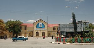 Location within Ethiopia
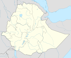
 Dire Dawa
Coordinates: 9°36′N 41°52′E / 9.6°N 41.867°E Country Ethiopia Region Dire Dawa Zone Dire Dawa District Dire Dawa Government - Type Chartered City - Mayor Adem Farah [1] Elevation 1,708 m (5,604 ft) Population (2008) - City 607,321 - Density 4,530/km2 (11,732.6/sq mi) - Metro 1,274,869 Time zone EAT (UTC+3) Area code(s) (251-25) Dire Dawa is one of two chartered cities (astedader akabibi) in Ethiopia (the other being the capital, Addis Ababa). This chartered city is divided administratively into two woredas, the city proper and the non-urban woreda of Gurgura.
Dire Dawa lies in the eastern part of the nation, on the Dechatu River, at the foot of a ring of cliffs that has been described as "somewhat like a cluster of tea-leaves in the bottom of a slop-basin."[2] With a latitude and longitude of 9°36′N 41°52′E / 9.6°N 41.867°ECoordinates: 9°36′N 41°52′E / 9.6°N 41.867°E, this city is the second largest in Ethiopia.
The city is an industrial centre, home to several markets and the Aba Tenna Dejazmach Yilma International Airport. Haramaya University is 40 kilometers away from the city.
Contents
History
Dire Dawa was founded in 1902 after the Addis Ababa - Djibouti Railway reached the area. The railroad could not reach the city of Harar at its higher elevation, so Dire Dawa was built nearby. This led to Dire Dawa becoming an important center of trade between the port of Djibouti and the capital city, Addis Ababa. (Dire Dawa is home to several market centers; the biggest being Taiwan along with Qefira which is located on the flood plain. Near Dire Dawa and what is now Kebele 01, trading happened in the town called Melka Jebdu and in fact, it has been the gateway for most of the goods sold in places such as Taiwan.). Dire Dawa's first governor was Ato Mersha Nahu Senay who also represented Emperor Menilek at the inauguration ceremony of the Djibouti-Ethiopia railway as it reached the area, according to Dr. Richard Pankhurst and historian Shiferaw Bekele. Ato Mersha was instrumental in the founding and early development of the city, including the establishment of the Djibouti-Dire Dawa railway that began in 1897 and ended in 1902.
Soon afterwards, Ras Makonnen, the governor of Harar, ordered the construction of a road from Dire Dawa to Harar, one of the first in this part of the country. This road was substantially improved in 1928, improving travel times between the two cities from two days to only a few hours.[3] A generation later, the writer C.F. Rey described the city as the most "advanced" urban center in the area, with good roads, electric lights and piped water.[4]
In 1931, the Bank of Ethiopia opened its first branch in Dire Dawa.[5]
During the Italian invasion, Mussolini ordered that both Addis Ababa and Dire Dawa would be spared air attacks as a response of demands of the United States and certain European countries for the safety of their citizens. On 6 May 1936 Graziani's units, advancing from Harar, reached the barbed-wire fence at Dire Dawa where they met two French armed cars; the railway was under French administration, and with the departure of Emperor Haile Selassie two days earlier, they remained to protect French interests. The next day, the first train under Italian control left Addis Ababa carrying the 46th Infantry Regiment. The two Italian forces met in Dire Dawa, and the occupation of the town was more or less a formality.[5]
Following the return of Emperor Haile Selassie, Dire Dawa was among the early provincial towns to have its own football league. Around 1947, their Taffari team participated in the Ethiopian Championship series. That same year, the Railroad Workers Syndicate of Dire Dawa, a labor union was formed for welfare purposes.[5] Although its leadership co-operated with the Government, it attempted to strike in 1949 which was brutally suppressed by government troops in 1949; at the time, all strikes were seen by government officials as a form of insurrection.[6]
In 1955 a public address system was installed in the central square, for receiving radio transmissions from the state radio and re-broadcasting them.[5]
The Ethiopian revolution affected the city in many ways. Starting March 1974, there was some unrest of workers; six people were wounded when police opened fire on demonstrating railwaymen and students on 17 April. Many Europeans, Yemeni Arabs and Indians left Dire Dawa; the Greek and Armenian churches were eventually closed due to dwindling membership. On 3 February 1975 the Derg announced that the Cotton Company of Ethiopia was among 14 textile enterprises to be fully nationalized. The cement factory was also later nationalized. In August 1976, the entire leadership of the local branch of the teachers' union was sacked for alleged anti-revolutionary activities. Ten new officials were appointed pending fresh elections.[5]
According to Gebru Tareke, the success of the Ethiopian Army in holding Dire Dawa (17-18 August 1977) against the Somali Army was decisive in winning the Ogaden War.[7]
Dire Dawa was occupied by the EPRDF 31 May 1991. There were reports of about 100 people killed resisting the EPRDF. In 1991, when the Somali National Movement took control of northern Somalia, they dismantled and sold the only publicly owned industry in the whole Somali northern region, a cement factory located near Berbera, which was shipped off to help expand the cement factory in Dire Dawa.[5] Both the Issa and Gurgura Liberation Front and the Oromo Liberation Front claimed the city; as a result, there were numerous clashes between the two groups from 1991 until 1993. This ongoing violence and the fear of protracted ethnic conflict caused the city to be designated federally administered city.[citation needed] Dire Dawa was separated from the Oromia Region around 1998 to become a chartered city.[8]
On June 24, 2002, a small explosive was detonated at the headquarters of the Ethiopian Railway Commission in Dire Dawa. The Oromo Liberation Front (OLF) afterwards claimed responsibility for this attack in retaliation "for the continuing harassment of Oromo students, merchants, and farmers by the Ethiopian government." Although blamed for other isolated incidents, this was the latest bombing inside Ethiopia for which the OLF claimed responsibility.[9]
The city was flooded in August 2006 when the Dechatu River overflowed its banks. About 200 people were reported dead, thousands were displaced and there was extensive damage to homes and markets. Floods are fairly common during the June-September rainy season; over 200 people in the region had been killed by flooding in 2005 that also did millions of dollars in damage.[10]
An overturned truck, heading from Dengego to Dire Dawa, killed a total of 41 people 4 March 2009. The truck was carrying an unknown number of day laborers when the accident happened, and 38 were immediately killed and as many as 50 were injured in the accident. Both dead and injured were taken to Dil-chora Hospital in Dire Dawa. The cause of the accident was not immediately known.[11]
Demographics
Based on the 2007 Census conducted by the Central Statistical Agency of Ethiopia (CSA), Dire Dawa has a total population of 341,834, of whom 171,461 are men and 170,461 women; 233,224 or 68.23% of the population are urban inhabitants. For all of Dire Dawa 76,815 households were counted living in 72,937 housing units, which results in an average of 4.5 persons to a household, with urban households having on average 4.2 and rural households 4.9 people. Ethnic groups in the region include the Oromo (45.9%), Somali (24.3%), Amhara (20.17%), Gurage (4.55%), Tigray (1.23%), and Harari (1.09%). Languages spoke include Oromiffa (47.95%), Amharic (26.46%), Somali (19.7%), Gurage (2.78%), and Harari (1.04%). The religion with the most believers in Dire Dawa is Muslim with 70.8%, 25.71% are Ethiopian Orthodox, 2.81% Protestant, and 0.43% Catholic.[12]
In the previous census, conducted in 1994, the city's population was reported to be 251,864, of whom 127,286 were men and 124,578 were women. The percentage of males and females is about 50.5 and 49.5 percent, respectively. The urban residents numbered at the time 173,188 while its rural residents were 78,676. For the entire administrative council there were 52,245 households in Dire Dawa administrative council with an average of 4.7 persons per household. The major ethnic groups included the Oromo (48%), Amhara (27.7%), Somali (13.9%), Gurage (4.5%; 2.3% Sebat Bet, 0.8% Sodo and 1.4% Silt'e); the remaining 5.9% of the population consists of all other ethnic groups.63.2% of the inhabitants are Muslim, 34.5% Orthodox Christian, 1.5% Protestant, 0.7% Catholic, and 0.1% followers of other religions.[13]
According to the CSA, as of 2004[update], 90.76% of the total population had access to safe drinking water: 69.61% of rural and 99.48% of urban inhabitants having access.[14] Values for other reported common indicators of the standard of living for Dire Dawa as of 2005[update] include the following: 11.4% of the inhabitants fall into the lowest wealth quintile; adult literacy for men is 76.6% and for women 53%; and the civic infant mortality rate is 71 infant deaths per 1,000 live births, which is less than the nationwide average of 77; at least half of these deaths occurred in the infants’ first month of life.[15]
Economy
Dire Dawa received postal service in August 1906, becoming the third location after Addis Ababa and Harar. Telephone service was available by 1954; by 1967, Dire Dawa had almost 500 telephone numbers, more than almost all other towns including Gondar, Harar, and Jimma.[5] The CSA estimated in 2005 that farmers in Dire Dawa had a total 40,400 head of cattle (representing 0.1% of Ethiopia's total cattle), 46,280 sheep (0.27%), 118,770 goats (0.92%), 8,820 asses (0.35%), 5,070 camels (1.11%), 44,740 poultry of all species (0.14%), and 840 beehives (less than 0.1%).[16]
The invasive weed Parthenium hysterophorus (or Congress weed) was first observed in Ethiopia near Dire Dawa in 1980. Experts speculate that it entered the country either through the Djibouti - Addis Ababa railway line or the International Airport, carried by one of the various food aid programs.[17]
About 2007, a Concrete sleeper factory was established, sited near the cement factory.
Intercity bus service is provided by the Selam Bus Line Share Company.
Chairmen of the Administrative Council
- Dametew Demissie 1990s
- Solomon Hailu 1990s - 2003
- Fisseha Zerihun 2003 - 2006
- Abdulaziz Mohammed 7 August 2006 - 2008
- Adem Farah June 2008 - 2010
- Asad Ziad June 2010 - present
(This list is based on information from Worldstatesman.org.)
See also
Notes
- ^ http://www.diretube.com/dire-dawa-tv/dire-dawa-mayor-adem-farah-wishing-happy-new-year-video_1f12c85fa.html
- ^ C.F. Beckham and G.W.B. Huntingford, Some Records of Ethiopia, 1593-1646 (London: Hakluyt Society, 1954), p. 224 n.1.
- ^ Richard R.K. Pankhurst, An Economic History of Ethiopia (Addis Ababa: Haile Selassie University Press, 1968), pp. 289, 290.
- ^ Cited in Pankhurst, Economic History, p. 620
- ^ a b c d e f g "Local History in Ethiopia" (pdf) The Nordic Africa Institute website (accessed 1 March 2008)
- ^ Edmund J. Keller, Revolutionary Ethiopia (Bloomington: Indiana University Press, 1988), p. 147
- ^ Gebru Tareke, "The Ethiopia-Somalia War of 1977 Revisited", International Journal of African Historical Studies, 2000 (33, #3), pp. 635ff at pp. 645-647. (accessed 13 May 2009)
- ^ States of Ethiopia at statoids.com
- ^ MIPT Terrorism Knowledge Base "Oromo Liberation Front (OLF) attacked Government target (June 24, 2002, Ethiopia)", last accessed 22 April 2006.
- ^ Scores killed in Ethiopia floods, BBC News, 6 August 2006
- ^ "Death toll for recent road accident reaches 41: Police" Ethiopian News Agency website, dated 5 March 2009 (accessed 14 April 2009)
- ^ Census 2007 Tables: Dire Dawa, Tables 2.1, 2.5, 3.1, 3.2 and 3.4
- ^ http://www.csa.gov.et/surveys/Population%20and%20Housing%20Census%201994/survey0/data/docs%5Creport%5CStatistical_Report%5Ck15%5Ck15.pdf
- ^ "Households by sources of drinking water, safe water sources" CSA Selected Basic Welfare Indicators (accessed 28 January 2009)
- ^ Macro International Inc. "2008. Ethiopia Atlas of Key Demographic and Health Indicators, 2005." (Calverton: Macro International, 2008), pp. 2, 3, 10 (accessed 28 January 2009)
- ^ "CSA 2005 National Statistics", Tables D.4 - D.7.
- ^ Rezene Fessehaie1, Mekasha Chichayibelu1, and Mengistu Haile Giorgis, "Spread and Ecological Consequences of Parthenium hysterophorus in Ethiopia", Arem. 6 (2005): 11-21 (accessed 30 April 2009)
External links
- Cities of Ethiopia: Dire Dawa, part I by John Graham (Addis Tribune, 23 November 2001)
- Cities of Ethiopia: Dire Dawa, part II by John Graham (Addis Tribune, 30 November 2001)
- FDRE States: Basic Information - Dire Dawa
- Investment Opportunities: Dire Dawa (Embassy of Ethiopia to the United States website)
- Dire Dawa Administration website
- Dire Dawa Civil Service Bureau website(Dire Dawa, Silversun, Liltide, diredawa)
 First-level administrative divisions of Ethiopia
Regions Chartered cities Addis Ababa · Dire DawaProvinces
(prior to 1995)Cities of Ethiopia Adama (Nazret) · Addis Ababa · Adigrat · Adwa · Ambo · Arba Minch · Asella · Awasa · Axum · Bahir Dar · Debre Berhan · Debre Marqos · Debre Tabor · Debre Zeyit · Degehabur · Dembidolo · Dessie · Dila · Dire Dawa · Gambela · Goba · Gode · Gondar · Harar · Irgalem · Jijiga · Jimma · Kebri Dahar · Kombolcha · Mek'ele · Negele Arsi · Negele Boran · Nekemte · Shashamane · Sodo · Weldiya · Wukro · Ziway
Categories:- Dire Dawa
- Regions of Ethiopia
- City-states


Wikimedia Foundation. 2010.