- Debre Tabor
-
Debre Tabor
ደብረ ታቦር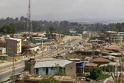 Location in Ethiopia
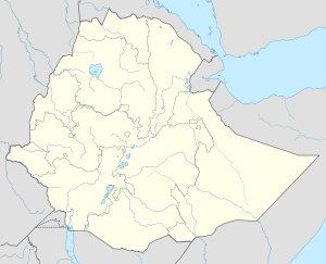
 Debre Tabor
Coordinates: 11°51′N 38°1′E / 11.85°N 38.017°ECoordinates: 11°51′N 38°1′E / 11.85°N 38.017°E Country Ethiopia Region Amhara Region Zone Debub Gondar Zone Elevation 2,706 m (8,878 ft) Population (2005) - Total 39,052 (est) Time zone EAT (UTC+3) Debre Tabor (also called Samara) is a town and a woreda in north-central Ethiopia. Located in the Debub Gondar Zone of the Amhara Region of Ethiopia, about 100 kilometers southeast of Gondar and 50 kilometers east of Lake Tana, this historic town has a latitude and longitude of 11°51′N 38°1′E / 11.85°N 38.017°E with an elevation of 2706 meters above sea level. The town is named for the Biblical Mount Tabor ("Debre Tabor" in Amharic means "Mount Tabor"). The presence of at least 48 springs in the area contributed to the development of Debre Tabor.
Debre Tabor is served by an airport (ICAO code HADT, IATA DBT).
Contents
History
Debre Tabor was the capital of Ethiopia under two Emperors: Tewodros II, before he moved the capital to Magdala; and Yohannes IV. As a result, in the 19th century the population of this town varied depending on whether the emperor was in residence. If he was present, the population could reach 30,000 as it did under Emperor Yohannes; if he was not, it would be around 5,000 people.[1]
Authorities differ over the facts of its founding. Mordechai Abir states that it was founded by Ras Ali I;[2] however, Richard Pankhurst gives a detailed account of its foundation by Ras Gugsa, and includes the tradition that the location was selected with supernatural help.[3] In either case, Debre Tabor was the seat of the Regents of the Emperor in the 18th and 19th centuries, from which periods several churches and the ruins of two palaces survive.
Debre Tabor was sacked by an army from the province of Lasta in 1835.[4] The Battle of Debre Tabor was fought nearby on February 6, 1842; although Dejazmach Wube Haile Maryam and his allies defeated the armies of Ras Ali II and sacked Debre Tabor once again, they were surprised while celebrating their victory by Birru Aligas, an ally of Ras Ali, who captured Wube and his son and extracted concessions from them in return for their release.[5]
Ras Ali built four churches in Debre Tabor: Iyasus on the mountain to the southeast, Ennatitu Maryam and Legitu Maryam to the east, and Tegur Mikael to the north. A second palace was built for his mother, the Empress Menen Liben Amede, which was not as large as Ras Ali's.[6]
Although he burnt the town in May 1853, following Ras Ali's defeat, Emperor Tewodros used Debre Tabor as his capital until his situation weakened so badly that he was forced to abandon the town (October 1867) for his stronghold on Maqdala.[7] The Emperor Yohannes IV often resided at Debre Tabor, and during his reign Heruy Giyorgis church was built. Here the Emperor met with General Gordon in October 1878, who was representing the Egyptian government, about Ethiopian demands for access to the Red Sea. It was also in Debre Tabor that Tekle Haymanot was crowned Negus of Gojjam in January 1881.[8]
When the Bank of Ethiopia was created in 1931 it opened a branch office with two employees at Debre Tabor. During the Second Italian-Abyssinian War, Debre Tabor was occupied by unit which advanced from Bahir Dar on 28 April. During the occupation, a telegraph office was opened in the town and postal service restored. The Italians also constructed a road from Gondar via Debre Tabor to Dessie. The first mosque in Debre Tabor was constructed and eucalyptus planting extended. Despite these improvements, as early as August 1937, there were almost simultaneous but apparently uncoordinated attacks by arbegnoch on garrisons near Debre Tabor and near Bahir Dar. After several months of attacks, the British convinced Colonel Angelini to surrender the town 6 July 1941, allowing the British to advance towards the organized Italian resistance around Gondar under the command of Guglielmo Nasi, who by this point was the acting Viceroy and Governor-General of Italian East Africa.[8]
In 1958, Debre Tabor was one of 27 places in Ethiopia ranked as First Class Township.[8]
Near the beginning of Derg rule, Debre Tabor was seized by a group of local landlords and their followers in opposition to the government September 1975, killing the provincial governor and expelling both a Chinese road-building team and missionaries of the Seventh Day Adventist Church who ran a local hospital. Government control was reestablished within a month.[8]
In late December 1989, Tigray People's Liberation Front (TPLF) forces captured Debre Tabor, claiming that they killed or wounded more than 8,000 government troops. Around 20 January 1990, the ENA news agency announced that government forces had recaptured Debre Tabor. A few days later, the clandestine radio of the TPLF claimed a major victory in battles near Debre Tabor on 22–24 January 1990, claiming their soldiers had killed 3,914 government troops and captured 270. Although the town was retaken by government troops a few days later, the TPLF, announced the recapture of the town after a three-day battle in late February.[8] About a year later, on 23 February 1990, the town was used as the jumping-off point for Operation Tewodros.[9]
Demographics
Based on figures from the Central Statistical Agency in 2005, Debre Tabor has an estimated total population of 39,052 of whom 20,078 are men and 18,974 are women. The woreda has an estimated area of 5.85 square kilometers, which gives Debre Tabor a density of 6,675.60 people per square kilometer.[10]
The 1994 national census reported a total population for Debre Tabor of 22,455 in 4,700 households, of whom 10,564 were men and 11,891 were women. The largest ethnic group reported in this town was the Amhara (98.93%); Amharic was spoken as a first language by 99.26%, while 92.62% of the population practiced Ethiopian Orthodox Christianity and 6.15% of the population said they were Muslim.[11]
Notes
- ^ Richard P.K. Pankhurst, An Economic History of Ethiopia, 1800-1935 (Addis Ababa: Haile Selassie I University Press, 1968), p. 694.
- ^ Mordechai Abir, Ethiopia: Era of the Princes (London: Longmans, 1968), p.30.
- ^ Richard P.K. Pankhurst, History of Ethiopian Towns (Wiesbaden: Franz Steiner Verlag, 1982), p. 265.
- ^ Pankhurst, Ethiopian Towns, p. 266.
- ^ Abir, Era of Princes, pp. 111f; Pankhurst, Ethiopian Towns, p. 268.
- ^ Pankhurst, Ethiopian Towns, pp. 271ff.
- ^ Sven Rubenson, King of Kings: Tewodros of Ethiopia (Addis Ababa: Haile Selassie I University, 1966), pp. 43,82
- ^ a b c d e "Local History in Ethiopia" (pdf) The Nordic Africa Institute website (accessed 9 May 2008)
- ^ Gebru Tareke notes that this military action "has come to be known as the second battle of Debre Tabor" despite the fact it "was not one big, decisive engagement but a series of skirmishes." (The Ethiopian Revolution: War in the Horn of Africa [New Haven: Yale University, 2009], p. 302)
- ^ CSA 2005 National Statistics, Table B.4
- ^ 1994 Population and Housing Census of Ethiopia: Results for Amhara Region, Vol. 1, part 1, Tables 2.1, 2.7, 2.10, 2.13, 2.17, Annex II.2 (accessed 9 April 2009)
External links
- Cities of Ethiopia: Debre Tabor by John Graham (Addis Tribune, 1 October 2001)
Cities of Ethiopia Adama (Nazret) · Addis Ababa · Adigrat · Adwa · Ambo · Arba Minch · Asella · Awasa · Axum · Bahir Dar · Debre Berhan · Debre Marqos · Debre Tabor · Debre Zeyit · Degehabur · Dembidolo · Dessie · Dila · Dire Dawa · Gambela · Goba · Gode · Gondar · Harar · Irgalem · Jijiga · Jimma · Kebri Dahar · Kombolcha · Mek'ele · Negele Arsi · Negele Boran · Nekemte · Shashamane · Sodo · Weldiya · Wukro · Ziway
Former woredas 
Current woredas Debre Tabor · Dera · Ebenat · Farta · Fogera · Kemekem · Lay Gayint · Mirab Este · Misraq Este · Simada · Tach GayintCategories:- Populated places in the Amhara Region
- Woredas of Ethiopia


Wikimedia Foundation. 2010.