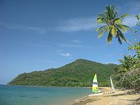
- Dunk Island
-
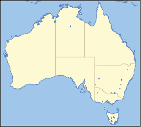
Dunk Island Nearest town/city Mission Beach Coordinates 17°56′48″S 146°09′22″E / 17.94667°S 146.15611°ECoordinates: 17°56′48″S 146°09′22″E / 17.94667°S 146.15611°E Area 10 km² Dunk Island lies 4 km off the Australian east coast, opposite the town of Mission Beach. The island forms part of the Family Islands National Park and is in the larger Great Barrier Reef World Heritage Area.[1]
The island is surrounded by reefs and has a diverse population of birds. Aboriginals once used the island as a source of food. Europeans first settled on the island in 1897. Dunk Island was used by the Royal Australian Air Force during World War II. In recent years the island and its resort facilities were affected by both Cyclone Larry and Cyclone Yasi.
Contents
Geology and wildlife
Dunk Island is by far the largest island in the Family Islands National Park, all of which consist of granite rock.[2] All of the islands were part of the mainland before the last sea level rise began 8,000 years ago. Dunk Island covers 970ha, of which 730 ha is national park and the rest is freehold. Its topography varies, with sandy beaches and rocky shores, slightly undulating slopes, foothills and steeper semi-rugged terrain. Mount Kootaloo is the island's highest point, at 271 m above sea level.
There are over 100 species of birds on Dunk Island, including rare and vulnerable seabirds.[2] During the summer months, the island becomes a breeding site for terns and noddies. The lack of predators, along with a plentiful supply of food from the surrounding reef waters, make it an ideal nesting site. Dunk Island is also home to reptiles such as pythons, tree snakes, geckos and skinks. The island's fringing reefs and surrounding waters are home to an array of marine life such as sea turtles, dugongs, corals, fish, shellfish and crabs. Purtaboi Island (the small island directly out from Dunk Island) is closed and inaccessible for guests from October through to April each year due to the crested terns nesting on the island.
History
Early history
The traditional Aboriginal owners of Dunk Island are the Bandjin and Djiru people,[1] who have lived in this area for tens of thousands of years.[2] After the sea level rise, they paddled to the islands in bark canoes to gather food and materials. The Aboriginal name for Dunk Island is Coonanglebah, or “The Island of Peace and Plenty”. It received its European name from Captain Cook, who sailed past it on 8 June 1770,[2] remarked that it was a "tolerable high island" and named it after George Montague-Dunk, 2nd Earl of Halifax.[3]
 HMS Rattlesnake, painted by Sir Oswald Walters Brierly, 1853.
Europeans settled the nearby mainland during the 1800s, seeking gold, timber and grazing land.[2] In 1848, John MacGillivray studied the fauna and flora of the island while HMS Rattlesnake was anchored off the island for ten days.[4] He subsequently wrote of its natural features in the Narrative of the Voyage of HMS Rattlesnake, published in England in 1852.[3]
Dunk Island, eight or nine miles in circumference, is well wooded—it has two conspicuous peaks, one of which (the North-West one) is 857 feet in height. Our excursions were confined to the vicinity of the watering place and the bay in which it is situated. The shores are rocky on one side and sandy on the other, where a low point runs out to the westward. At their junction, and under a sloping hill with large patches of brush, a small stream of fresh water, running out over the beach, furnished a supply for the ship, although the boats could approach the place closely only at high-water.
— John MacGillivray, Narrative of the Voyage of HMS Rattlesnake
In 1897, suffering from work anxiety and exhaustion, and advised by doctors that he had just six months to live, writer Edmund James Banfield moved to Dunk Island with his wife Bertha - so becoming the island’s first white settlers. Previously a Journalist and Senior Editor with the Townsville Daily Bulletin for fifteen years, Banfield let the tranquillity of this unspoilt tropical paradise weave its magic and he lived on Dunk Island for the remaining 26 years of his life until his death in 1923. A small hut built with the assistance of an Aborigine called Tom was the Banfield’s first home. Over a period of time they cleared four acres of land for a plantation of fruit and vegetables. Combined with their chickens, cows and goats as well as the abundance of seafood and mangrove vegetation, they lived very self-sufficiently. Fascinated by Dunk Island’s flora and fauna Banfield meticulously recorded his observations and went on to write a series of articles about island life under the pseudonym Rob Krusoe. He was further inspired to write a full-length book entitled ‘Confessions of a Beachcomber’ which was published in 1908.[5] The book became a celebrated text for romantics and escapists and established Dunk Island’s reputation as an exotic island paradise. In the ensuing years, Banfield wrote several other books about Dunk including ‘My Tropical Isle’ in 1911 and ‘Tropic Days’ in 1918. In these he shared the secrets of nature that he had uncovered and described the customs and legends of the Aboriginal people on the island. E J Banfield died on 2 June 1923 and his final book ‘Last Leaves from Dunk’ was published posthumously in 1925. His widow remained on the island for another year before moving to Brisbane where she died, ten years after her husband. Today both are buried on the trail to Mt Kootaloo.[6]
World War II and the development of the resort
The island was bought in 1934 by Captain Brassey and Banfield's bungalow provided the basis for the beginnings of a resort.[3] The Royal Australian Air Force occupied Dunk Island during World War II, building its airstrip in 1941.[2] They installed a radar station on the island's highest point a year later, which was then dismantled when the war ended in 1945. The Brassey family returned to run the resort for a period at the end of the war. The island then went through a succession of owners. In 1956, Gordon & Kathleen Stynes purchased the island and relocated their family from Victoria to Dunk Island. The Stynes Family then set about to redevelop and upgrade the resort’s facilities to establish the island as a tourist destination. As a result, Dunk Island became a popular destination for celebrities including Sean Connery, Henry Ford II and former Australian Prime Ministers Harold Holt and Gough Whitlam. The Stynes Family owned and operated the island and resort until 1964 when it was sold to Eric McIlree, founder of Avis Rent-A-Car.
In 1976, Trans Australia Airlines purchased Dunk Island. Ownership then passed to Qantas in 1992, following its merger with Australian Airlines. On 24 December 1997, the island was purchased by P&O Australian Resorts, who were then acquired by Voyages in July 2004.[7] In September 2009, both Dunk and Bedarra island resorts were purchased by Hideaway Resorts, a wholly owned subsidiary of Pamoja Capital.
Weather
Dunk Island is located in the tropics and has an average year-round temperature of approximately 29 degrees Celsius (85 degrees Fahrenheit).[8] History of cyclones affecting Dunk Island contained within Climatic Events section.
Land use
National park
Dunk Island has thirteen kilometres of walking tracks spread over five main routes, ranging from a short walk to Edmund James Banfield's grave to a 4 hour island circuit hike.[9] Commercial operators offer guided tours around the island, as does the Dunk Island resort.
Ferry
Quick Cat runs the only jetty to jetty ferry service between Mission Beach and Dunk Island, and Dunk and Bedarra Island guest transfers. The Dunk Island Ferry has eight daily transfers between the Clump Point Jetty at Mission Beach and the Dunk Island Jetty.
Resort
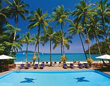
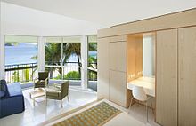
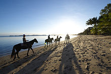
Dunk Island Resort is run by Hideaway Resorts, comprising 160 rooms popular with families and couples.[10] Its facilities include two restaurants, two bars, a café, a spa and a 9-hole golf course. The resort offers a number of free and paid activities for its guests, including day trips to other parts of the Great Barrier Reef.
Camping ground
There is also a camping ground available for visitors as part of the national park, although a permit is required for its use.[9]
Artists' colony
Dunk Island is also home to a small community of artists who live, work and showcase their work on a property on the southern side of the island.[11] The Colony was established in 1974 by former Olympic wrestler Bruce Arthur, and continued to operate after his death in 1998, until Cyclone Larry damaged much of the colony. Susie Kirk now resides at the Artist colony.
Airstrip
Dunk Island also has a small airstrip, Dunk Island Airport, located near the resort, with frequent flights to Cairns.[12]
Climatic Events
Cyclone Larry
On 20 March 2006, Cyclone Larry's eye crossed the coast of Queensland at Innisfail as the Category 4. Around 160 staff members and 280 guests from Dunk Island had been evacuated to Cairns, but 20 Voyages staff stayed behind on the island.[13] The resort suffered structural and water damage,[14] but reopened on 1 July 2006[15] after an estimated $20 million of refurbishment and rebuilding.[13]
Cyclone Yasi
Between AEST 23:57, 2 February 2011, and 00:27, 3 February 2011, the eye of Cyclone Yasi passed directly over Dunk Island as a Category 5 tropical cyclone. Mobile phone communication was lost due to the nearest base station at Mission Beach being destroyed and power lost at 22:00 as the cyclone approached. The resort was equipped with satellite phones and generators.[16][16] Dunk Island Resort guests and some staff were flown to safety on 1 February 2011.[17][18]
Impact on Dunk Island Resort Staff
The 109 Dunk Island Resort staff and the General Manager David Henry[16] who were on the island at the time were forced into lockdown, four to a room, with rations that involved only a sandwich and an apple.[19] It was alleged by staff that they were not given the option to evacuate despite Police asking the island's management to do so a week prior.[19][20][21][22] Staff stated that the resort island's management told staff they had to stay and help with the cleanup,[23] some were even ordered back to work from the mainland as the cyclone approached including an employee who, allegedly, had sliced off part of their thumb in a boat accident.[24][25] Staff alleged resort bosses told them not to speak to the media.[24] An unnamed Hideaway Resorts spokeswoman said, “They (staff) were given the choice to leave or stay and many chose to stay and bunker down".[26]
Hideaway Resorts Director Andrew Menzies yesterday denied staff were forced to stay, but could not be evacuated because the cyclone tracked south late on 2 February 2011. Andrew Menzies was quoted saying, “We followed cyclone procedures, there was never a forced evacuation communicated to anyone", he said. Additionally, "We have cyclone-rated buildings to a category 5, so this was actually the safest place to be". Rupert Greenhough from Hideaway Resorts said the islands followed "established cyclone procedures", which did not include provision for mass evacuation of staff.[19][25]
Hideaway Resorts CEO Mark Campbell and Director Andrew Menzies flew via helicopter to Dunk Island on 3 February 2011 to access the damage. Chairman Rupert Greenhough expressed relief staff had survived the cyclone and described that outcome as a testament to the planning and preparations undertaken to meet those situations.[27]
On 4 February 2011, staff, other than a skeleton team, were all stood down until the resort was rebuilt, evacuated from the island via helicopters and water taxi and offered counselling.[19][22][28][29]
The Herald Sun alleged that when management found out journalists were on the island, they were ushered away from staff and directed to speak to the island's Melbourne based co-owner and the boss of the resort who spent the cyclone sheltering in luxury Shangri-La Resort in Cairns.[24]
On 5 February 2011, the Sunshine Coast Daily reported that statements purporting to cover Bedarra Resort released by management of Hideaway Resorts on the 4 February 2011 actually referred to only its Dunk Island property that neighbours Bedarra Island.[30]
Dunk Island Resort Infrastructure Damage
The damage to the resort was described as being smashed beyond recognition with much of the resort needed to be completely rebuilt. Almost all the beachfront apartments were peeled apart by the wind. The usually cyclone-hardy palm trees resemble deformed stalks.[31] The resort's iconic pool was completely filled with sand from the associated storm surge. The function hall was gutted and the health centre was unroofed. Almost all of the beachfront apartments had their walls torn off and were left empty shells by the ferocious winds.[32] The cyclone's impact on the resort was greatly destructive; buildings in splinters, facilities in ruins and gardens stripped bare. It was also described as a paradise lost and unrecognisable.
Shortly after the cyclone damage was assessed all bookings were cancelled.[33] Due to reconstruction the Resort has planned to recommence accepting reservations in early 2012 for stays from the 1 April 2012. [34]
In popular culture
- Dunk Island was chosen as the location for the 1969 film Age of Consent, which was based on a story by the artist and writer Norman Lindsay.[11] Directed by Michael Powell, it starred James Mason as Bradley Morahan, a jaded Australian artist returning from New York and Helen Mirren as Cora Ryan, a local teenager. Age of Consent attracted controversy over nudity and a sex scene, which led to some censorship and cuts. Much of the film was shot on the beach at Brammo Bay where ferries bringing visitors now dock.
- An assignment in the penultimate round of the third season of The Mole required the four remaining players to draw a rough map of Dunk Island. This assignment was won after contestants Marc Jongebloed and Bob Young submitted a drawing which roughly resembled the map of the island.
- One of the final scenes in James Cameron’s movie “Sanctum” was shot on Muggy Muggy beach.[35]
See also
References
- ^ a b "About Family Islands". Department of Environment and Resource Management. http://www.derm.qld.gov.au/parks/family-islands/about.html. Retrieved 10 May 2011.
- ^ a b c d e f "Family Islands National Park – Nature, culture and history". Department of Environment and Resource Management. http://www.derm.qld.gov.au/parks/family-islands/culture.html. Retrieved 10 May 2011.
- ^ a b c "Dunk Island". The Sydney Morning Herald. 8 February 2004. http://www.smh.com.au/news/queensland/dunk-island/2005/02/17/1108500203297.html. Retrieved 12 June 2008.
- ^ MacGillivray, John (1852). "1.3". Narrative of the Voyage of H.M.S. Rattlesnake. 1. London: T. & W. Boone. http://www.gutenberg.org/files/12433/12433-h/12433-h.htm. Retrieved 12 June 2008.
- ^ Banfield, Edmund. Confessions of a Beachcomber. http://www.gutenberg.org/etext/5113. Retrieved 12 June 2008.
- ^ http://gutenberg.net.au/pages/banfield.html
- ^ "Our Journey". Voyages. http://www.voyages.com.au/corporate/our-journey/. Retrieved 12 June 2008.[dead link]
- ^ www.dunk-island.com
- ^ a b "Family Island National Park - features". EPA/QPWS. Archived from the original on 3 August 2008. http://web.archive.org/web/20080803132444/http://www.epa.qld.gov.au/parks_and_forests/find_a_park_or_forest/family_islands_national_park/. Retrieved 13 June 2008.
- ^ "Dunk Island Resort". Hideaway Resorts. http://www.dunk-island.com. Retrieved 29 September 2009.
- ^ a b Woodard, Amanda (29 October 2005). "Fantasy island". The Guardian. http://www.guardian.co.uk/travel/2005/oct/29/onlocationfilminspiredtravel.australia.guardiansaturdaytravelsection?page=all. Retrieved 13 June 2008.
- ^ "Getting to Dunk Island and back". Voyages. Archived from the original on 19 July 2008. http://web.archive.org/web/20080719055226/http://www.dunk-island.com/getting/. Retrieved 13 June 2008.
- ^ a b Wright, John (7 October 2006). "Slammed Dunk is back". AdelaideNow.... http://www.news.com.au/adelaidenow/story/0,22606,20525613-5006339,00.html. Retrieved 12 June 2008.
- ^ "TNQ Islands Closed in Wake of Cyclone Larry". Voyages. 20 March 2006. http://www.voyages.com.au/media/200/. Retrieved 12 June 2008.
- ^ "Voyages Dunk & Bedarra Islands Re-opening Update". Voyages. 17 May 2006. http://www.voyages.com.au/media/206/. Retrieved 12 June 2008.
- ^ a b c Dunk Island employees bunker down, NineMSN, 3 February 2011 (accessed 4 February 2011)
- ^ Cyclone Yasi crosses the coast at Mission Beach, 50km south of Innisfail, Courier Mail, 3 February 2011 (accessed 4 February 2011)
- ^ Dunk Island resort staff staying put, The Cairns Post, 2 February 2011 (accessed 2 February 2011)
- ^ a b c d Dunk Island after the cyclone, The Cairns Post, 5 February 2011 (accessed 5 February 2011)
- ^ Resort 'stopped staff leaving' ahead of cyclone, ABC News, 3 February 2011 (accessed 4 February 2011)
- ^ Resort 'stopped staff leaving' ahead of cyclone, Weatherzone, 3 February 2011 (accessed 4 February 2011)
- ^ a b Resort boss defends keeping staff on Dunk Island, The Australian, 5 February 2011 (accessed 5 February 2011)
- ^ "Chef told to endure storm". Waikato Times. 4 February 2011. http://www.stuff.co.nz/waikato-times/news/4617626/Chef-told-to-endure-storm. Retrieved 29 September 2011.
- ^ a b c Fury and relief at smashed resort in Dunk Island, Herald Sun, 5 February 2011 (accessed 5 February 2011)
- ^ a b Yasi dunks resorts in sand, Courier Mail 5 February 2011 (accessed 5 February 2011)
- ^ Dunk and Bedarra Island staff safe after Cyclone Yasi, The Cairns Post, 3 February 2011 (accessed 4 February 2011)
- ^ Marooned staff safe but sorry, Sunshine coast Daily, 4 February 2011 (accessed 4 February 2011)
- ^ Yasi dunks resorts in sand, Courier Mail, 5 February 2011 (accessed 5 February 2011)
- ^ Dunk and Bedarra pick up pieces after cyclone Yasi, The Cairns Post, 4 February 2011 (accessed 4 February 2011)
- ^ I thought he would die mum, Sunshine Coast Daily, 3 February 2011 (accessed 3 February 2011)
- ^ Morning heralds the big clean-up, Herald Sun, 4 February 2011 (accessed 4 February 2011)
- ^ Coming home to heartbreak, Courier Mail, 4 February 2011 (accessed 4 February 2011)
- ^ Tropical Cyclone Yasi Update, Dunk Island website, 4 February 2011 (accessed 6 February 2011)
- ^ Dunk News, Dunk Island website, April 2011 Newsletter (accessed 11 June 2011)
- ^ http://www.cairns.com.au/article/2010/03/25/101951_local-news.html
Categories:- Islands on the Great Barrier Reef
- Far North Queensland
Wikimedia Foundation. 2010.

