- Northwood, London
-
Coordinates: 51°36′04″N 0°25′03″W / 51.601°N 0.4176°W
Northwood 
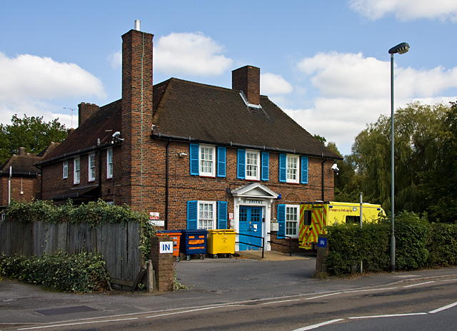
Northwood & Pinner Cottage Hospital, built in 1926
 Northwood
Northwood shown within Greater LondonOS grid reference TQ095915 - Charing Cross 14.5 mi (23.3 km) SE London borough Hillingdon Ceremonial county Greater London Region London Country England Sovereign state United Kingdom Post town NORTHWOOD Postcode district HA6 Dialling code 01923 Police Metropolitan Fire London Ambulance London EU Parliament London UK Parliament Ruislip, Northwood and Pinner London Assembly Ealing and Hillingdon List of places: UK • England • London Northwood is a suburban area in Greater London, and is part of the London Borough of Hillingdon.
The population was recorded as 11,068 in 2008, by the Office for National Statistics.[1]
Contents
History
Toponomy
Northwood was first recorded in 1435 as Northwode, formed from the Old English 'north' and 'wode', meaning 'the northern wood', in relation to Ruislip.[2] Northwood Hills shares the origin.[2]
Urban development
By 1891, Northwood had 115 houses, one shop and one public house. In 1901, there was a population of 2,500, with around 500 houses and 26 shops.[3]
The monks of the Bec Abbey who lived at Manor Farm in Ruislip in the 11th century owned a grange in Northwood.[4]
Robert Cecil, 1st Earl of Salisbury had 568 acres (230 ha) cleared in the Manor of Ruislip in 1608. Much of this land was in Northwood, and the area remained as wasteland until the 1814 Enclosure Act.[4]
A land survey conducted in 1565 by King's College, Cambridge, the new lords of the manor of Ruislip, recorded ten houses and several farms.[5]
By 1881, the population of Northwood had reached 257, with 62 houses recorded. The Eastbury estate owned by David Carnegie covered much of the area by that time. In 1887, the Metropolitan Railway was extended from Harrow-on-the-Hill to Rickmansworth, and Carnegie sold his land to Frank Murray Maxwell Hallowell Carew for development for £59,422.[6] Northwood station opened in August that year.[5]
Carew stipulated the prices for the new housing he had built, with the cottages along the west side of the High Street priced at £120. He had hoped these would be owned by the staff of the larger houses in the area. The High Street itself had been a track leading on from Rickmansworth Road to Gate Hill Farm.[7] The first shops opened in 1895 on the east side of the road, and included a hairdresser, butchers and a fishmongers.[8] Carew sold the majority of the estate to George Wieland in 1892.[5]
By 1902, the population had reached 2,500, with a total of 500 houses and 36 shops also recorded.[5] In 1904, the Emmanuel Church opened, having been designed by Sir Frank Elgood, a local architect. It had been built in 1895, originally to serve as a school.[9] Sir Frank also served as chairman of the Ruislip-Northwood Urban District Council.[8]
Northwood and Pinner Cottage Hospital was built in 1926 as a memorial to the First World War, using donations from the Ruislip Cottagers' Allotments Charity.[10] The hospital was closed in 2008 after the Hillingdon Primary Care Trust admitted it had become too costly to maintain. In 2010, the trust announced the hospital would remain empty for another four years, while funding was used to improve services in other areas of the London Borough of Hillingdon.[11] In 2011, the trust admitted the hospital could remain closed for a further ten years.[12]
Northwood is home to Northwood Headquarters, based in the grounds of Eastbury Park, the estate purchased by David Carnegie in 1857. The Royal Air Force took over the site in 1939 for the use of RAF Coastal Command which made use of Eastbury house and also created a network of underground bunkers and operations blocks. The house was used as an Officers' Mess, though was subsequently damaged by fire.[13] The RAF vacated the site in 1969, and it is now the location of the British Armed Forces Permanent Joint Headquarters (PJHQ) for planning and controlling overseas military operations, together with the NATO Regional Command.[14]
Geography
The Northwood post town of the HA postcode area area extends into Hertfordshire to include Eastbury and Moor Park. A triangular area of Northwood including the old High Street, Chester Road and Hallowell Road has been deemed a place of special-interest restriction, in order to protect the numerous Victorian houses situated there.
Air disaster
On 4 July 1948 a Scandinavian Airlines Douglas DC-6 on a flight from Amsterdam to RAF Northolt collided with a RAF Avro York coming from Malta over Northwood. Both aircraft crashed, killing all 39 people on both aircraft.[15]
Transport
The area is served by Northwood, Northwood Hills and Moor Park London Underground stations, situated along the Metropolitan line.
Schools
See the List of schools in Hillingdon
Sport
The area is home to Northwood F.C. and Northwood Cricket Club
Local government
Northwood was part of the ancient parish of Ruislip and became part of the Ruislip-Northwood Urban District in 1904.[16] The urban district was abolished in 1965 and merged with others to became part of the London Borough of Hillingdon in Greater London. Northwood has three elected local Councillors: Cllr Scott Seaman-Digby (first elected 1998), Cllr Richard Lewis (first elected 2002) and Cllr Carol Melvin (first elected 2008). They can be contacted via London Borough of Hillingdon, High Street, Civic Centre, Uxbridge, UB8 1UW. [17]
The MP for the constituency of Ruislip, Northwood and Pinner is currently Nick Hurd, who was elected in the May 2010 general election with 57.5% of the vote. The current voting constituency was created from the former Ruislip-Northwood and parts of the Harrow West constituency, for the 6 May 2010 general election.
Nearest places
Notable people
- Actress Kathleen Byron (1921-2009) lived in Northwood at the time of her death
- Television and radio presenter Fearne Cotton was born in Northwood
- Sir William Dickson (1898-1987), former head of the British armed forces, was born in Northwood
- Roger Hilton (1911-1975), post-war pioneer of abstract art, was born in Northwood
- Film director Derek Jarman (1942-1994), whose credits include Jubilee and The Tempest (1979), was born in Northwood
- Actor Geoffrey Keen (1916-2005) lived in Northwood at the time of his death
- Actress Betty Marsden (1919-1998) lived in Northwood at the time of her death
- Actor David Quilter was born in Northwood
- Actress Patsy Smart (1918-1996) lived in Northwood at the time of her death
- Character actor Geoffrey Toone (1910-2005) lived in Northwood at the time of his death
References
Citations
- ^ "A focus on Northwood". London Borough of Hillingdon. January 2010. http://www.hillingdon.gov.uk/media/pdf/4/d/Northwood_10.pdf. Retrieved 23 June 2011.
- ^ a b Mills 2000
- ^ Bowlt 1994, p.64
- ^ a b Bowlt 2007, p.59
- ^ a b c d Bowlt 2007, p.60
- ^ Bowlt 2007, p.65
- ^ Bowlt 2007, p.69
- ^ a b Bowlt 2007, p.70
- ^ Bowlt 2007, p.61
- ^ Bowlt 1994, p.46
- ^ Matti, Siba (22 June 2010). "Northwood and Pinner Cottage Hospital to remain closed for further four years". Uxbridge Gazette. http://northwood.uxbridgegazette.co.uk/2010/06/northwood-and-pinner-cottage-h.html. Retrieved 13 May 2011.
- ^ Matti, Siba (17 May 2011). "Hospital set to 'wither' for next decade". Uxbridge Gazette. http://www.uxbridgegazette.co.uk/west-london-news/local-uxbridge-news/2011/05/17/hospital-set-to-wither-for-next-decade-113046-28710262/. Retrieved 26 May 2011.
- ^ Bowlt 1994, p.62
- ^ "Northwood Headquarters". Ministry of Defence. 2011. http://www.mod.uk/DefenceInternet/AboutDefence/WhatWeDo/DoctrineOperationsandDiplomacy/PJHQ/NorthwoodHeadquarters.htm. Retrieved 11 April 2011.
- ^ Fisher, Barbara (7 July 2008). "Families return to air disaster now almost forgotten". Uxbridge Gazette. http://www.uxbridgegazette.co.uk/west-london-news/uxbridge-history/2008/07/07/families-return-to-air-disaster-now-almost-forgotten-113046-21305996/. Retrieved 11 April 2011.
- ^ Vision of Britain - Ruislip parish (historic map) population (area ). Retrieved on 10 March 2010.
- ^ Cotton 1994
Bibliography
- Bowlt, Eileen. M. (1994) Ruislip Past. London: Historical Publications ISBN 094866729X
- Bowlt, Eileen. M. (2007) Around Ruislip, Eastcote, Northwood, Ickenham & Harefield. Stroud: Sutton Publishing ISBN 978-07509-4796-1
- Cotton, Carolynne. (1994) Uxbridge Past. London: Historical Publications ISBN 0948667303
- Mills, D. (2000) Oxford Dictionary of London Place Names. Oxford
London Borough of Hillingdon Districts Colham Green · Cowley · Cowley Peachy · Eastcote · Harefield · Harefield Grove · Harlington · Harmondsworth · Hayes · Hillingdon · Hillingdon Heath · Ickenham · Longford · Mount Pleasant · Newyears Green · North Hillingdon · Northwood · Northwood Hills · Ruislip · Ruislip Gardens · Ruislip Manor · Sipson · South Ruislip · Uxbridge · West Drayton · Yeading · Yiewsley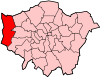
Attractions Battle of Britain Bunker · Beck Theatre · Compass Theatre · Eastcote House Gardens · Heathrow Airport · Hillingdon Cycle Circuit · Hillingdon Sports and Leisure Complex · Ickenham Hall · Manor Farm · Polish War Memorial · Ruislip Lido · Southlands Arts Centre · Swakeleys House · The Mall Uxbridge · Uxbridge Cricket Club GroundParks and open spaces Bayhurst Wood Country Park · The Closes Recreations Ground · Cranford Park · Mad Bess Wood · Rockingham Recreation Ground · Ruislip Woods · Uxbridge CommonConstituencies Tube and rail stations Eastcote · Hatton Cross · Hayes and Harlington railway station · Heathrow Central railway station · Heathrow Terminals 1, 2, 3 · Heathrow Terminal 4 · Heathrow Terminal 4 railway station · Heathrow Terminal 5 station · Hillingdon · Ickenham · Northwood · Northwood Hills · Ruislip · Ruislip Manor · Ruislip Gardens · South Ruislip station · Uxbridge · West Drayton railway station · West Ruislip stationOther topics People · Public art · Schools
 Category ·
  CommonsCategories:
- Districts of London
- Districts of Hillingdon


Wikimedia Foundation. 2010.