- Cheam
-
Coordinates: 51°20′52″N 0°12′41″W / 51.3478°N 0.2113°W
Cheam 
 Cheam
Cheam
Cheam shown within Greater LondonOS grid reference TQ245625 London borough Sutton Ceremonial county Greater London Region London Country England Sovereign state United Kingdom Post town SUTTON Postcode district SM2, SM3 Dialling code 020 Police Metropolitan Fire London Ambulance London EU Parliament London UK Parliament Sutton and Cheam London Assembly Croydon and Sutton List of places: UK • England • London Cheam (
 /ˈtʃiːm/) is a large suburban village close to Sutton in the London Borough of Sutton, England, and is located close to the southern boundary between Greater London and Surrey. It is divided into two main areas: North Cheam and Cheam Village. North Cheam includes more retail shops and supermarkets, whilst Cheam Village and the south of Cheam are more residential. It is bordered by Worcester Park (to the north-west), Morden (to the north-east), Sutton (to the east), Ewell (to the west) as well as Banstead and Belmont to the South. Cheam is one of the southernmost areas in Outer London under the control of a Greater London Authority (The London Borough of Sutton) as opposed to Surrey County Council, which controls bordering towns to the South and West including Banstead and Ewell. It is located in London Travelcard Zone 5, and the area is served by Cheam railway station.
Contents
History
The village lay within the Anglo-Saxon administrative division of Wallington hundred.
Cheam's roots can be dated back as far as 1018, when Chertsey Abbey owned the area. In the Domesday Book, the Bishop was holding Cheam to cater for the monks.
Cheam appears in Domesday Book as Ceiham. It was held by Archbishop Lanfranc of Canterbury. Its Domesday assets were: 4 hides; 1 church, 17 ploughs, 1-acre (4,000 m2) of meadow, woodland worth 25 hogs. It rendered £14.[1]
In the Middle Ages, Cheam was known for its potteries[citation needed], and recent excavations have been carried out by archaeologists. In 1538, part of Cheam was handed over to Henry VIII. The same year, Henry began work on Nonsuch Palace, which he decorated fantastically. This was later sold and demolished. In 1801, the time of the first census, Cheam had a population of 616.
Cheam was the original home of Cheam School which was formed in Whitehall in 1645 and later occupied Tabor Court from 1719 until 1934 when the school moved to Berkshire. Prince Philip attended the school in Cheam in the years immediately preceding its move.
Places of interest
Lumley Chapel
Main article: Lumley ChapelSituated next to St Dunstan's church, it is the oldest standing building in the London Borough of Sutton. It contains many notable monuments to local families and is in the care of a national charity the Churches Conservation Trust. Too small to be used for regular worship it is open to visitors with the key being held by nearby properties.
Whitehall
Whitehall is a timber framed and weatherboarded house in the centre of Cheam Village. It was originally built in about 1500 as a wattle and daub yeoman farmer's house but has been much extended. The external weatherboarded appearance dates from the 18th century. In the garden there is a medieval well which served an earlier building on the site.
The building is open to the public on Wednesday, Thursday & Friday 2-5pm; Saturday 10 am - 5 pm, Sunday & Bank Holiday Monday 2-5 pm. There is an admission charge, and an audio guide. There is a programme of events and changing exhibitions in the house, which also has displays about the history of the house and its inhabitants, nearby Cheam School, and Henry VIII's Nonsuch Palace.
Nonsuch Mansion
A Gothic revival mansion within Nonsuch Park built in 1802-6. The service wing is occasionally open to the public. A popular place for wedding receptions, as it is available for hire.
The Old Rectory
A large part timber-framed house, built in Tudor period, but extended and remodelled in the Eighteenth Century. Occasionally open to the public.
The Old Farmhouse
A large timber-framed and weatherboarded Yeoman farmers house, forming part of the Cheam Conservation Area with St Dunstan's Church, Whitehall, The Old Rectory and the Lumley Chapel. The Old Farmhouse has a crown post roof and large Tudor axial chimney stack in the centre with large fireplaces. The earliest part of the house is 15th Century, with several building stages extending the house in the 16th and 17th centuries, creating a Baffle House design popular in the 17th Century. Many original features remain including oak doors and hinges, window shutters and fireplaces. Much of the timber framing is exposed throughout the house. Recent excavation and ground imaging uncovered a large Tudor kitchen underneath the house with a Tudor hearth and hood visible. Access to the cellar kitchen was by a staircase going north to south, which is now under the floor of the current owners kitchen. A file of text and images relating to the house is available in the Conservation Archive in Sutton Library.
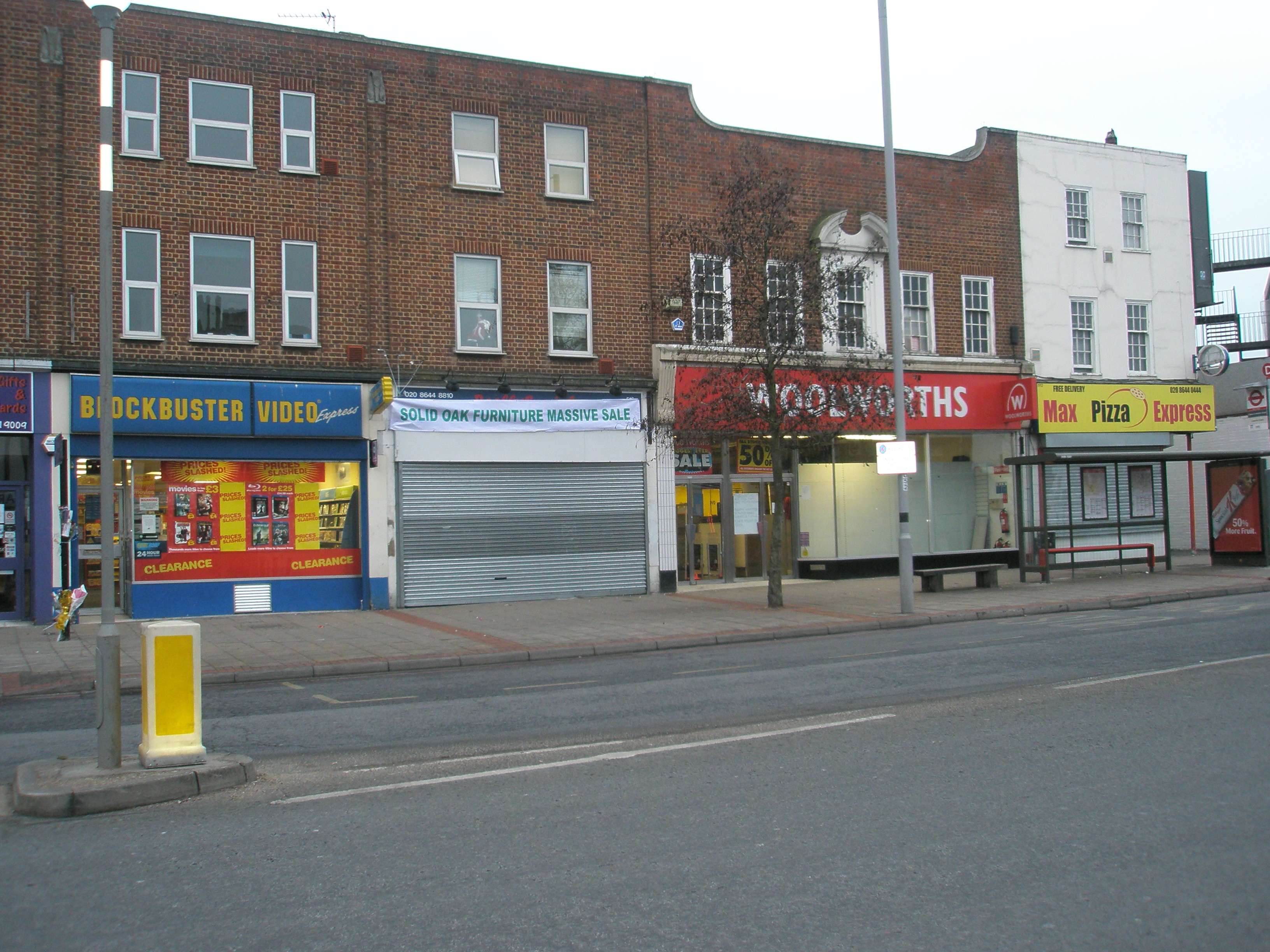
North Cheam
 North Cheam in 2009
North Cheam is situated at the main cross roads between Sutton and Central London. There are well established bus services serving the area, including services 213 (Sutton to Kingston), 151 (Wallington to Worcester Park), 93 (North Cheam to Putney Bridge) and the less frequent X26 express service between Heathrow and Croydon. The nearest tube station is in Morden.
Victoria Junction is the centre of North Cheam. The area consists of a Sainsbury's supermarket, a neighboring park, numerous independent shops and restaurants, a post office and several banks. The North Cheam branch of Woolworths, which had been in existence since the 1950s, closed on 30 December 2008.
St. Anthony's Hospital is a large private hospital which exists on the London Road in North Cheam.
Cheam Leisure Centre, on Malden Road, offers facilities including a swimming pool (30m x 12m), squash courts and fitness gym.
Parks and gardens
Today Cheam is mainly built up, but still retains Nonsuch Park, also home to a chicken pen, drinking fountain, ice cream shop, and car park. Cheam Park backs onto Nonsuch Park, with many facilities such as tennis courts, football pitches and a children's playground.
Schools
There are a number of schools in Cheam, most notably Nonsuch High School, a grammar school for girls and Cheam High School, a mixed comprehensive which is considerably above average. There are also a number of primary schools in the area such as Cuddington Croft, St Cecilias Catholic Primary School, Cheam Fields Primary, Cheam Common Primary, Cheam Park Farm Nursery and Infants School, Cheam Park Farm Juniors, Nonsuch Primary and St. Dunstans Church of England Primary.
Cultural references
In most series of the comedy show Hancock's Half Hour, Tony Hancock lived in the fictional road Railway Cuttings, in fictional East Cheam.
British stand-up comedian and actor Eddie Izzard mentions Cheam in the 'Death Star Canteen' act of his 2000 tour Circle, using it jokingly as the birth place of Darth Vader: "... Sir Lord Vader? Sir Lord Vader of Cheam?"
British stand-up comedian Tim Vine mentions Cheam in his act.
Notable people
- Harry Secombe once lived in Cheam
- David Bellamy attended Cheam Fields Primary School
- Tim Vine was born in Cheam
- Jeremy Vine grew up in Cheam
- Paul Greengrass was born in Cheam
- Mark Worrall resides in Cheam
- Alec Stewart (ex-England cricketer) lived in South Cheam
- Peter Manley was born in Cheam
- Koop Arponen, a winner in the Finnish version of Pop Idol attended Cheam High School
- Carrie Quinlan lived in Cheam and attended Nonsuch High School
- Jimmy Mann resides in Cheam, attended Cheam Fields primary school
Film locations
- St. Dunstan's Church was used in an episode of The I.T. Crowd Series 2.
- Peep Show used Cheam Park for a location shoot.
- An episode of Terry and June features the walkway between the library car park and St. Dunstans Church.
- The Village crossroads was used in a police chase on The Bill.
- South Drive and the houses within, where used for a soap opera during the mid-90's.
- The Old Rectory was used as a location for the rap group N-Dubz in the group's earlier videos
- The Bill used the Nonsuch Manor House in Nonsuch Park in one of its episodes.
Nearby places
References
External links
- Cheam at the Open Directory Project
- Hancock's Legacy David McKie in The Guardian, November 30, 2006.
- Cheam Rangers [1]
London Borough of Sutton Districts Beddington · Beddington Corner · Belmont · Benhilton · Carshalton · Carshalton Beeches · Carshalton on the Hill · Cheam · Hackbridge · St Helier · Sutton · The Wrythe · Wallington · Worcester Park
Attractions Parks and open spaces Constituencies Other topics People · Public art · SchoolsCategories:- Districts of London
- Districts of Sutton
- Districts of London listed in the Domesday Book


Wikimedia Foundation. 2010.