- Monte Aprazível
-
Monte Aprazível — Municipality — The Municipality of
Monte Aprazível
Flag
SealLocation of Monte Aprazível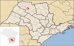
Coordinates: 20°46′21″S 49°42′51″W / 20.7725°S 49.71417°WCoordinates: 20°46′21″S 49°42′51″W / 20.7725°S 49.71417°W Country  Brazil
Region Southeast State  São Paulo
Mesoregion São José do Rio Preto Government – Mayor Wanderley Sant'Anna Area – Total 496.9 km2 (191.9 sq mi) Elevation 475 m (1,558 ft) Population (2010/IBGE) – Total 21,746 – Density 43.76/km2 (113.3/sq mi) Time zone UTC-3 (UTC-3) – Summer (DST) UTC-2 (UTC-2) Postal Code 15150-000 Area code(s) +55 17 'HDI (UNDP/2000) 0.808 – high Website Prefecture of Monte Aprazível Monte Aprazível is a municipality in the state of São Paulo, Brazil. The population is of 21,746 inhabitants, and the area is 496.9 km².[1]
Known as "The Dream's Dam City", because of a dam located nearby the city center.
Monte Aprazível belongs to the Mesoregion of São José do Rio Preto and is located 475 km from the city of São Paulo.
Contents
History
Monte Aprazível was grounded by Captain Porfírio de Alcântara Pimentel, who was born in the city of Areias, São Paulo. In December 18, 1914, the district is created, and in December 23, 1924, the municipality is established with the emancipation from Rio Preto.[2]
Economy
The Tertiary sector and the Industry are the economic basis of Monte Aprazível. Commerce, services and public administration corresponds to 49% of the city GDP. The Secondary sector is 45.5% of the GDP, and the Primary sector corresponds to 5.5%.[3]
Transportation
- SP-310 Rodovia Feliciano Sales Cunha
- SP-377 Rodovia Deputado Bady Bassitt
References
- ^ "Population at "Censo 2010"" (in Portuguese). IBGE.gov.br. http://www.ibge.gov.br/home/estatistica/populacao/censo2010/tabelas_pdf/Sao_paulo.pdf. Retrieved 14 Jul 2011.
- ^ "History of the City". Monteaprazivel.sp.gov.br. http://www.monteaprazivel.sp.gov.br/pagina_abrir.asp?pid=1&t=Hist%F3ria%20do%20Munic%EDpio.asp. Retrieved 15 July 2011.
- ^ "Municipal Profile at SEADE". SEADE.gov.br. http://www.seade.gov.br/produtos/perfil/perfilMunEstado.php. Retrieved 15 July 2011.
Demographics of Brazil Economic and social Apartheid · Attractions · Law · Crime · Education · GDP · Health · Human Development · Human Rights (LGBT Rights) · Immigration · Languages · People · Politics · Poverty · Races · Religions · Traditions · Wealth
Ethnic groups BrazilAfricaAmericasNorth AmericaCaribbeanHaitianSouth AmericaBy EthnicityBy Country
or RegionEasternSouthernEast IndianWesternEuropeBy EthnicityBy Country
or RegionNorthernWesternCentralSouthernBalkanEasternCategories:- Populated places in São Paulo (state)
- Cities in São Paulo (state)


Wikimedia Foundation. 2010.