- Karafuto Prefecture
-
樺太庁 (Shinjitai)
樺太廳 (Kyūjitai)
Karafuto PrefecturePrefecture of the Great Japanese Empire ← 
1907 – 1945  →
→

Flag Coat of arms Green: Karafuto Prefecture within Japan in 1942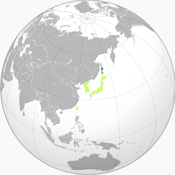
Light green: Other constituents of Imperial JapanCapital Toyohara History - Becomes prefecture 1907 - Initial colonization 1905 (-1907) - Becomes prefecture 1907 - Upgraded to "inner land" 1943 - Autonomy December 1 1945 - Soviet occupation August 25, 1945 Population - December 1941 406,557 Karafuto Prefecture (樺太庁 Karafuto-chō), commonly called South Sakhalin, was the Japanese administrative division corresponding to Japanese territory on Sakhalin from 1905 to 1945. Through the Treaty of Portsmouth, the portion of Sakhalin south of 50°N became a colony of Japan in 1905. In 1907 the prefecture of Karafuto was established, with its capital at Ōtomari (大泊, now Korsakov) in 1905 and later Toyohara (豊原, now Yuzhno-Sakhalinsk) in 1907. In 1945, with the defeat of Japan in World War II, the Japanese administration in Karafuto ceased to function, and since 1951, the southern part of Sakhalin has been a part of Russia.
Contents
History
Japanese settlement on Sakhalin dates to at least the Edo period. Ōtomari was established in 1679, and cartographers of the Matsumae domain mapped the island, and named it “Kita-Ezo”. Japanese cartographer and explorer Mamiya Rinzō established that Sakhalin was an island through his discovery of what is now named Mamiya Strait in 1809. Japan unilaterally proclaimed sovereignty over the whole island in 1845, but its claims were ignored by the Russian Empire.
The 1855 Treaty of Shimoda acknowledged that both Russia and Japan had joint rights of occupation to Sakhalin, without setting a definite territorial demarcation. As the island became settled in the 1860s and 1870s, this ambiguity led to increasing friction between settlers. Attempts by the Tokugawa shogunate to purchase the entire island from the Russian Empire failed, and the new Meiji government was unable to negotiate a partition of the island into separate territories.
In the Treaty of Saint Petersburg (1875), Japan agreed to give up its claims on Sakhalin in exchange for undisputed ownership of the Kuril Islands.
Sakhalin was invaded by Japan in the final stages of the Russo-Japanese War of 1904–1905, but per the 1905 Treaty of Portsmouth was allowed to retain only the southern portion of the island below the 50° N parallel. Russia retained the northern portion, although the Japanese were awarded favorable commercial rights, including fishing and mineral extraction rights in the north.
In 1907, Karafuto Prefecture was officially established, with the capital at Ōtomari. In 1908, the capital was relocated to Toyohara.
Following the Nikolaevsk Incident in 1920, Japan briefly seized the northern half of Sakhalin, and occupied it until the establishment of formal diplomatic relations with the Soviet Union in 1925; however, Japan continued to maintain petroleum and coal concessions in northern Sakhalin until 1944.
In 1920, Karafuto was officially designated an external territory of Japan, and its administration and development came under the aegis of the Ministry of Colonial Affairs.
In 1942, the status of Karafuto was upgraded to that of an "inner land" (内地 naichi), making it an integral part of the Empire of Japan.
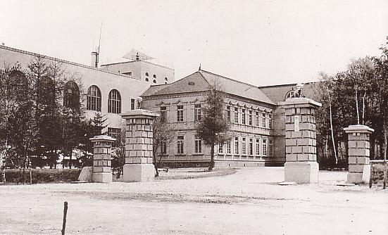
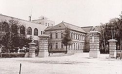 Karafuto Prefectural Office.
Soviet invasion
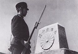
In August 1945, after repudiating the Soviet–Japanese Neutrality Pact, the Soviet Union invaded Karafuto. The Soviet attack on southern Karafuto started on 11 August 1945, a few days before the surrender of Japan. The Soviet 56th Rifle Corps, part of the 16th Army, consisting of the 79th Rifle Division, the 2nd Rifle Brigade, the 5th Rifle Brigade and the 214 Armored Brigade,[1] attacked the Japanese 88th Infantry Division. Although the Soviet Red Army outnumbered the Japanese by three to one, they advanced only slowly due to strong Japanese resistance. It was not until the 113th Rifle Brigade and the 365th Independent Naval Infantry Rifle Battalion from Sovetskaya Gavan landed on Tōro, a seashore village of western Karafuto on August 16 that the Soviets broke the Japanese defense line. Japanese resistance grew weaker after this landing. Actual fighting continued until August 21. From August 22 to August 23, most remaining Japanese units agreed to a ceasefire. The Soviets completed the conquest of Karafuto on 25 August 1945 by occupying the capital of Toyohara.
Evacuation and legal flux
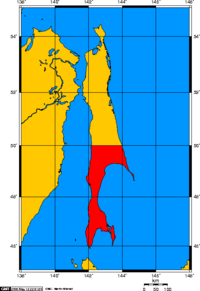
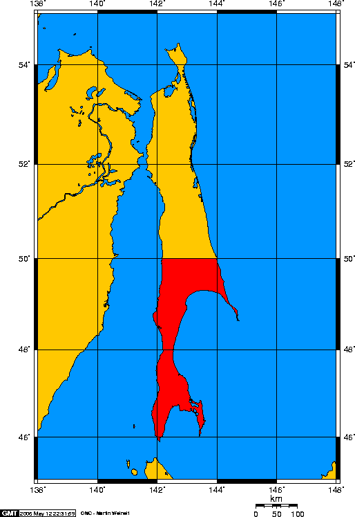
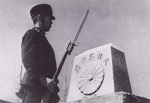
 Border between Karafuto and Soviet Sakhalin.
There were over 400,000 people living on Karafuto when the Soviet offensive began in early August 1945. Most were of Japanese or Korean extraction, though there was also a small White Russian community as well as some Ainu indigenous tribes. By the time of the ceasefire approximately 100,000 civilians had managed to escape to Hokkaidō. The military government established by the Soviet Army banned the local press, confiscated cars and radio sets and imposed a curfew. Local managers and bureaucrats were made to aid Russian authorities in the process of reconstruction, before being deported to slave-labor camps, either on North Sakhalin or in Siberia. In schools, courses in Marxism-Leninism were introduced, and Japanese children were obliged to sing songs in praise of Stalin.
Step by step Karafuto lost its Japanese identity. South Sakhalin Oblast was created in February 1946, and by March all towns, villages and streets were re-named with Russian names. More and more colonists began to arrive from mainland Russia, with whom the Japanese were obliged to share the limited stock of housing. In October 1946 the Soviets began to repatriate all remaining Japanese. By 1950 most had been sent, willing or not, to Hokkaidō, though they had to leave all of their possessions behind, including any currency they had, Russian or Japanese, so they arrived on the Japanese home islands penniless and homeless. Today some keep alive the memory of their former home in the meetings of the Karafuto Renmei, an association for former Karafuto residents.
No final peace treaty has been signed between Japan and Russia, and the status of the neighboring Kuril Islands remains disputed. Japan renounced its claims of sovereignty over southern Sakhalin in the Treaty of San Francisco (1952), but did not formally acknowledge Russian sovereignty over it.[2] Unlike Kuril Islands, however, the area is not disputed between the two nations, as they both acknowledge that Japan renounced its sovereignty claim.
Current status
In 1945, with the defeat of Japan in World War II, the Japanese administration in Karafuto ceased to function, and in 1951, at the Treaty of San Francisco, Japan renounced its rights to Sakhalin. Since that time, the southern part of Sakhalin has been a part of Russia.
(For subsequent history, see Sakhalin Oblast.)
Geography
Economy
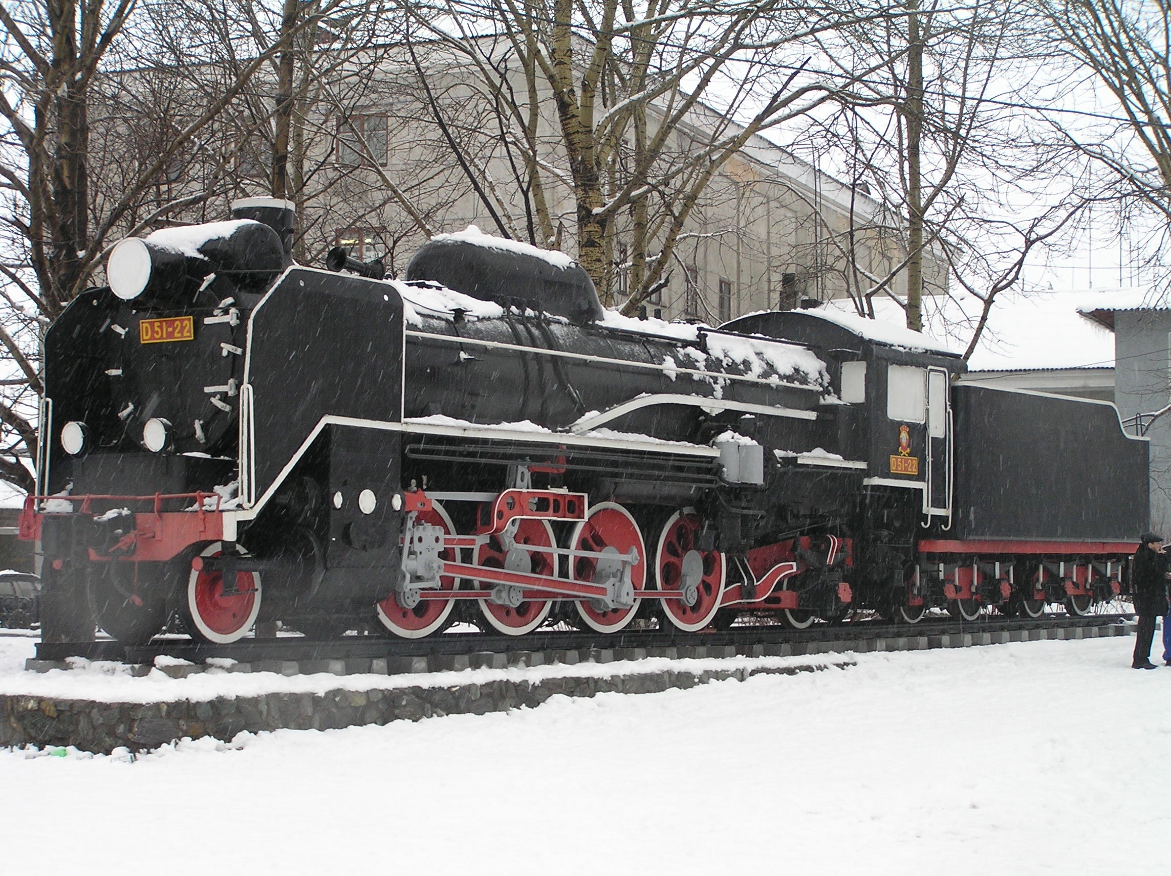
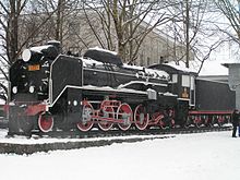 This Japanese D51 steam locomotive stands outside present day the Yuzhno-Sakhalinsk Railway Station Sakhalin Island, Russia. They were used by the Soviet Railways until 1979.
The pre-war economy of Karafuto was based on fishing, forestry and agriculture, together with extraction of coal and petroleum. In terms of industry, the paper industry and the charcoal production industry were well developed. Karafuto suffered from a labor shortage through most of its history, and tax incentives were provided to encourage immigration. During World War II, a large number of Koreans were also forcibly relocated to Karafuto.
An extensive railway network was constructed in Karafuto to support the extraction of natural resources. The Karafuto Railway Bureau (樺太鉄道局 Karafuto Tetsudōkyoku) maintained 682.6 kilometers of track in four main lines, and an additional 58.2 kilometers of track.
Government
Karafuto was administered from the central government in Tokyo as the Karafuto Agency (樺太庁 Karafuto-cho) under the Colonization Bureau (拓務局 Takumukyoku) of the Home Ministry. The Colonization Bureau became the Ministry of Colonial Affairs (拓務省 Takumushō) in 1923 at which time Karafuto was officially designated an overseas territory of the Empire of Japan.
When the Ministry of Colonial Affairs was absorbed into the new Ministry of Greater East Asia in 1942, the administration of Karafuto was separated, and Karafuto became an integral part of the Japanese home islands.
Directors of the Karafuto Agency
Name From To Kiichirō Kumagai July 28, 1905 March 31, 1907 Yukihiko Kusunose April 1, 1907 April 24, 1908 Takejirō Tokonami April 24, 1908 June 12, 1908 Sadatarō Hiraoka June 12, 1908 June 5, 1914 Bunji Okada June 5, 1914 October 9, 1916 Akira Masaya October 13, 1916 April 17, 1919 Kinjirō Nagai April 17, 1919 June 11, 1924 Akira Masaya (Second term) June 11, 1924 August 5, 1926 Katsuzō Toyota August 5, 1926 July 27, 1927 Kōji Kita July 27, 1927 July 9, 1929 Shinobu Agata July 9, 1929 December 17, 1931 Masao Kishimoto December 17, 1931 July 5, 1932 Takeshi Imamura July 5, 1932 May 7, 1938 Munei Toshikazu May 7, 1938 April 9, 1940 Masayoshi Ogawa April 9, 1940 July 1, 1943 Toshio Ōtsu July 1, 1943 November 11, 1947 Major cities
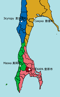 Karafuto Prefecture with 4 subprefectures, namely Toyohara, Maoka, Esutoru and Shikuka. Toyohara City was also a part of Toyohara Subprefecture.
As of 1945, Karafuto was divided into four subprefectures, which in turn were subdivided into 11 districts, in turn divided into 41 municipalities (one city, 13 towns, and 27 villages)
Karafuto's largest city was Toyohara. Other major cities included Esutoru in the north central and Maoka in the south central region.
The list below are the towns and the city of the prefecture. These in italics are the corresponding current Russian names.
Esutoru Subprefecture (恵須取支庁)
- Towns
Maoka Subprefecture (真岡支庁)
- Towns
Shikuka Subprefecture (敷香支庁)
- Towns
Toyohara Subprefecture (豊原支庁)
- City
-
- Toyohara (豊原市, Yuzhno-Sakhalinsk)
- Towns
Name
The Japanese name Karafuto (樺太) comes from Ainu Kamuy Kar Put Ya Mosir (カムイ・カラ・プト・ヤ・モシリ), which means "the island a god has created on the estuary (of Amur River)". It was formerly known as Kita Ezo (北蝦夷), meaning Northern Ezo (Ezo is the former name for Hokkaidō). When Japanese administered the prefecture, Karafuto usually meant Southern Sakhalin only. For convenience, the northern part of the island was sometimes called Sagaren (薩哈嗹).
In Russian, the entire island was named Sakhalin (Сахалин) or Saghalien. It is from Manchu Sahaliyan Ula Angga Hada, meaning "peak of the mouth of Amur River". The southern part was simply called Yuzhny Sakhalin (Южный Сахалин, "South Sakhalin").
In Korean, the name is Sahallin (사할린) or Hwataedo (화태도, 樺太島), with the latter name in use during Korea under Japanese rule.
Planned expansion
As Japan was extending its influence over East Asia and the Pacific through the establishment of a Greater East Asia Co-Prosperity Sphere, the Imperial Japanese Army as part of its offensive contingency plans to invade the Soviet Union if it either became involved in the Pacific War or collapsed due to the ongoing German invasion, proposed the annexation of the remaining northern half of Sakhalin to Japan.[3]
See also
- Organization of Karafuto Fortress
- Sakhalin Koreans
- Kuril Island conflict
References
- ^ 16th Army, 2nd Far Eastern Front, Soviet Far East Command, 09.08,45
- ^ Svela, Maria. "Sakhalin:The Japanese Under Soviet rule". History Today, Vol. 48, 1998.
- ^ Krebs, Gerhard (1997). "31. Japan and the German-Soviet War". In Wegner, Bernd. From peace to war: Germany, Soviet Russia, and the world, 1939-1941. Berghahn Books. p. 551. ISBN 1571818820.
- Sevela, Marie, « Sakhalin : The Japanese under Soviet rule ». History and Memory, 1998 (January), pp. 41-46.
- Sevela, Marie, « Nihon wa Soren ni natta toki. Karafuto kara Saharin e no ikô 1945-1948 ». Rekishigakukenkû, 1995, n° 676, pp. 26-35, 63.
External links
Former exterior territories of Japan Karafuto - Karafuto Minseisho → Karafuto Prefecture (incorporated into mainland jurisdiction)
Chōsen Taiwan - Governor-General of Taiwan
- Taihoku Prefecture
- Shinchiku Prefecture
- Taichū Prefecture
- Tainan Prefecture
- Takao Prefecture
- Karenkō Prefecture
- Taitō Prefecture
- Hōko Prefecture
Nan'yō - Rinji Nan'yō Guntō Bōbitai Minseisho → Nan'yō-chō
Kwantung - Kantō Totokufu → Kantō-chō → Kantō-kyoku: Kantō-shūchō
Categories:- States and territories established in 1907
- States and territories disestablished in 1945
- Karafuto
- Subdivisions of Japan
- Empire of Japan
- Former prefectures of Japan
- Former Japanese colonies
- States and territories established in 1905
- Japan–Soviet Union relations


Wikimedia Foundation. 2010.