- Cleburne State Park
-
Coordinates: 32°16′00″N 97°33′28″W / 32.266705°N 97.5578°W

Cleburne State Park is a 500-acre (2.0 km2) Texas state park in Johnson County, Texas operated by the Texas Parks and Wildlife Department. The park includes the 116-acre (0.47 km2), spring-fed Cedar Lake that was created by construction of an earthen dam by the Civilian Conservation Corps.
The park is reached via US 67 to Park Road 21.
Contents
History
Cleburne State Park is named for the nearby town of Cleburne, Texas. It was opened in 1939 after purchase from the city. Earlier Commanche Indians hunted in the area and had a trail passing through.
Flora and fauna
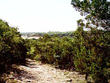
The park is heavily wooded with cedar, oak, elm, mesquite, redbud, cottonwood, sycamore, ash and sumac trees. The ground is rocky. Animal life includes white-tailed deer, turkey, duck, armadillo, squirrel, skunk, bobcat, swamp rabbit, cottontail rabbit, raccoon, opossum, coyote, beaver, and many species of birds. Species of fish in Cedar Lake include crappie, bass, catfish, bluegill, and red ear sunfish.
Facilities
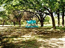
Cleburne State Park has a variety of campsites. All sites include a picnic table, grill and a campfire ring. Restrooms with hot showers are available nearby all camping areas.
Tent and parking space with water are common.
Back-in campsites with utilities and shelters accommodate up to 8 people and combination of motor vehicles/trailers.
Group Camp consists of a 2 group barracks with twin beds and mattresses sleeping a total of 44 people. The dining hall and kitchen seat approximately 70 people and has some cooking equipment. All buildings are heated but no air-conditioning.
Activities
Fishing is an extremely popular activity on the lake. Boating is allowed although the speed limit on the lake is restricted to 5 mph (8.0 km/h) which prohibits speed and personal water craft and creates a quiet peaceful atmosphere.
5.5 miles (8.9 km) of mountain bike trails of various skill levels are available in a loop around the park. The terrain on the trail is diverse, including hills and flats. Hiking is also allowed on these trails and there are at least two geocaches located in the park.
There is an entrance fee to the park and reservations are recommended.
External links
Protected Areas of Texas Federal El Orcoquisac Archeological District · Fort Davis National Historic Site · Lyndon B. Johnson National Historical Park · Palo Alto Battlefield National Historical Park · San Antonio Missions National Historical ParkAnahuac · Aransas · Attwater Prairie Chicken · Balcones Canyonlands · Big Boggy · Brazoria · Buffalo Lake · Grulla · Hagerman · Laguna Atascosa · Lower Rio Grande Valley · McFaddin · Muleshoe · San Bernard · Santa Ana · Texas Point · Trinity RiverState Abilene · Atlanta · Balmorhea · Barton Warnock Environmental Education Center · Bastrop · Bentsen-Rio Grande Valley · Big Bend Ranch · Big Spring · Blanco · Boca Chica · Bonham · Brazos Bend · Buescher · Caddo Lake · Caprock Canyons · Cedar Hill · Choke Canyon · Cleburne · Colorado Bend · Cooper Lake · Copper Breaks · Daingerfield · Davis Mountains · Devils River State Natural Area · Devil's Sinkhole State Natural Area · Dinosaur Valley · Eisenhower · Enchanted Rock State Natural Area · Estero Llano Grande · Fairfield Lake · Falcon · Fort Boggy · Fort Parker State Park · Fort Richardson State Park · Franklin Mountains · Galveston Island · Garner · Goliad · Goose Island · Government Canyon State Natural Area · Guadalupe River · Hill Country State Natural Area · Honey Creek State Natural Area · Huntsville · Indian Lodge · Inks Lake · Kickapoo Cavern · Lake Arrowhead · Lake Bob Sandlin · Lake Brownwood · Lake Casa Blanca International · Lake Colorado City · Lake Corpus Christi · Lake Livingston · Lake Mineral Wells · Lake Somerville · Lake Tawakoni · Lake Texana · Lake Whitney · Lockhart · Longhorn Cavern · Lost Creek Reservoir State Trailway · Lost Maples State Natural Area · Martin Creek Lake · Martin Dies, Jr. · Matagorda Island · McKinney Falls · Meridian · Mission Tejas · Monahans Sandhills · Mother Neff State Park · Mustang Island · Palmetto · Palo Duro Canyon · Pedernales Falls · Possum Kingdom · Purtis Creek · Ray Roberts Lake · Resaca de la Palma · San Angelo · Sea Rim · Sheldon Lake · South Llano River · Stephen F. Austin · Tyler · Village Creek · Walter Umphrey · Wyler Aerial TramwayActon · Admiral Nimitz · Barrington Living History Farm at Washington-on-the-Brazos · Battleship TEXAS · Caddoan Mounds · Casa Navarro · Confederate Reunion Grounds · Eisenhower Birthplace · Fanthorp Inn · Fannin Battleground · Fort Griffin · Fort Lancaster · Fort Leaton · Fort McKavett · Fort Richardson · Fulton Mansion · Goliad · Hueco Tanks · Kreische Brewery · Landmark Inn · Levi Jordan Plantation · Lipantitlan · Lyndon B. Johnson · Magoffin Homestead · Mission Espiritu Santo · Mission Rosario · Monument Hill · Penn Farm · Point Isabel Lighthouse · Sabine Pass Battleground · Sam Bell Maxey House · Samuel T. Rayburn House · San Felipe · San Jacinto Battleground · Sauer-Beckmann Farm · Sebastopol House · Seminole Canyon · Starr Family Home · Varner–Hogg Plantation · Washington-on-the-Brazos · Zaragosa BirthplaceState Wildlife TrailsGreat Texas Coastal · Heart of Texas · Panhandle Plains · Prairies and PineywoodsTexas Parks and Wildlife Department Categories:- Protected areas of Johnson County, Texas
- Texas state parks
- Civilian Conservation Corps in Texas
Wikimedia Foundation. 2010.


