- Chinbrook
-
Coordinates: 51°25′54″N 0°01′53″E / 51.4316°N 0.0314°E
Chinbrook 
 Chinbrook
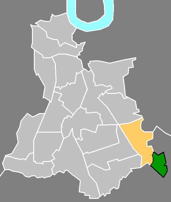
Chinbrook shown within Greater LondonOS grid reference TQ411722 London borough Lewisham Ceremonial county Greater London Region London Country England Sovereign state United Kingdom Post town LONDON Postcode district SE12, SE9 Dialling code 020 Police Metropolitan Fire London Ambulance London EU Parliament London UK Parliament Lewisham East London Assembly Greenwich and Lewisham List of places: UK • England • London  Chinbrook (green) within the ward of Grove Park (yellow), in the London Borough of Lewisham (light grey)
Chinbrook is a suburb in southeast London; it is located 14 km (8.7 mi) southeast of Charing Cross and is in the southeast corner of the London Borough of Lewisham on its boundary with the London Borough of Bromley. Chinbrook lies between Grove Park and Mottingham, approximately half a mile east of Grove Park centre and is generally considered part of Grove Park.
Most of Chinbrook including the main crossroads falls within the London Borough of Lewisham and under the postcode district SE12 , although immediately northeast from the crossroads is the border with the London Borough of Bromley and the SE9 postcode district. The River Quaggy flows northward through Chinbrook and forms part of the borough and postal boundaries there.[1]
Contents
Transport
The main crossroads has traffic lights and several bus stops close by. The main road, the B226, passes East to West through the hamlet; westward being Chinbrook Road toward Grove Park joining Baring Road (A2212), and northeast, Grove Park Road toward Mottingham. Marvels Lane is a smaller road passing north to south; southward it joins Dunkery Road, which goes eastward also towards Mottingham; northward Marvels Lane joins Burnt Ash Hill which goes through the northern part of Grove Park towards Lee. There are footpaths in the area mostly running north to south along the green area following the River Quaggy, and some form part of the Green Chain Walk and Capital Ring.
London Buses 126, 124, and 273 pass through Chinbrook using the same roads: Chinbrook Road, Marvels Lane then Dunkery Road. The 284 bus begins its route here at nearby Grove Park Cemetery and travels along Marvels Lane and Chinbrook Road.[2] The school bus 638 also passes through on Grove Park Road and Chinbrook Road.[3] Grove Park is only half a mile to the west along Chinbrook Road and has more buses and a train station. Chinbrook, like Grove Park centre is in London Travelcard Zone 4.
Amenities
Shops: Immediately west of the crossroads there is a parade of shops on the north side of Chinbrook road; the biggest shop here is a Costcutter small supermarket or convenience store on the corner. Other shops include several take-aways, a newsagent, off license and a beauty salon. There was previously a large public house with its own garden called Grove Park Tavern on the northeast corner of the main crossroads; this was demolished in the late 1990s and the site now contains retirement flats. Grove Park Tavern is still used sometimes to refer to the crossroads even though it no longer stands there; Transport for London continue to use it.[2]
 Grove Park Cemetery
Recreation: As well as the public Chinbrook Meadows there are also several private sports grounds, a youth club, and a Bannatyne's gym–health club, built in 2001 replacing an older sports club. These lie to the north and east of the crossroads within the London Borough of Bromley and the SE9 postcode district.
Marvels Lane Primary School is on Riddons Road in Grove Park Estate and backs onto Marvels Lane. The head teacher is Edward Dove.
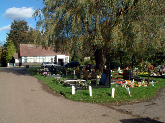
Grove Park Cemetery is found southeast of Chinbrook Meadows and Grove Park Estate; its entrance is at the southern end of Marvels Lane.
Jubilee International Church and South London Christian College are both located at 72a Mayeswood Road in the Grove Park Estate, and back onto Chinbrook Meadows. This is a Christian Pentecostal church, part of the Assemblies of God, with a leadership training centre for international students. The leader is Rev Dr Femi Olowo.
Residential
There is a mixture of terraced houses, semi-detached houses and flats on the through roads and cul-de-sac roads. There is a building on the northeast corner of the main crossroads containing many retirement flats, this was built in the late 1990s where Grove Park Tavern previously stood. There are two main housing estates in the area.
Grove Park Estate, to the southwest of the crossroads is a group of roads all with terraced houses, and some semi-detached houses between Marvels Lane and Chinbrook Meadows that was built by Lewisham council between 1926 and 1929.
Chinbrook Estate, to the southeast of the crossroads is several small roads, has two high tower blocks plus many smaller terrace houses and flats and two community centres. It lies in the south east corner of the Grove Park ward but comes under SE9 not SE12 like most of Grove Park. It is surrounded by and has entrances on Marvels Lane, Dunkery Road, Grove Park Road and Mottingham Sports Ground.
Chinbrook Meadows
Chinbrook Meadows sometimes Chinbrook Meadow is one of Lewisham's public open spaces or parks in the south of Chinbrook and Grove Park, the area was previously occupied by Chinbrook Farm, a dairy farm. The park was first formally opened to the public in 1929 and was then a children's play area of 8-acre (32,000 m2), on the edge of the recently built Grove Park Estate; London County Council purchased a further 23 acres (93,000 m2); and the larger area was opened to the public in June 1937.[4]
The majority of the park is maintained short grass with footpaths and lined with tall trees and bisected by the River Quaggy; the grass often has markings for football pitches, a cricket ground and other sports and is used by local schools for sports days. Chinbrook meadows also contains public toilets, public concrete tennis courts, and a football pitch and basketball court in one, plus a children's play area with a paddling pool. Some of the many footpaths crossing the park form part of The Green Chain Walk [5][6] and Capital Ring. The Quaggy River flows northward through Chinbrook Meadows. In the 1960s the river within the park was channelized into a long straight concrete culverts to alleviate flooding and was closed off behind tall hedges and iron fences, this cut the park in two with the larger part to the east of the river. In the early 2000s however the concrete channel with its fences and hedges was demolished and river was remodeled to give a natural, meandering appearance with a small flood plain; this was to encourage wild plants and animals back to the area and to be more pleasant and attractive for the public. There are several foot bridges with wooden hand rails over the river, that replaced the concrete ones with iron fences. The regeneration was completed on 1 October 2002 and cost a reported £1.1million.[7][8]
The small southern part of Chinbrook Meadows became allotments, but many were in disuse in the early 1990s and a government grant paid for trees to be planted on some of the area, although some of the allotments still remain in use.[4] The park is around half a mile long north to south, half as wide and is surrounded by Chinbrook Road to the north, Mayeswood Road to the east and the railway line to the south and west, under the railway line there is a pedestrian subway tunnel that crosses the borough boundary into Bromley and links the park to a much smaller green area southwest of the main park. The footpath that leaves the southeast corner of Chinbrook Meadows is part of the Green Chain Walk passes the allotments then Grove Park Cemetery before entering Elmstead Woods. Gates to the park are opened at 08:00 every morning and closing times range from 16:30 to 21:00 in the evening depending on the time of year.[9]
See also: :Category:Parks and open spaces in LewishamToponomy
The name Chinbrook is derived from "Chin Brook" which was an alternative name for the Quaggy River at the turn of the twentieth century.[10][11] The place Kidbrooke is also on the River Quaggy and its name is also derived from an alternative name for the river, "Kyd Brook". Chinbrook is occasionally mispronounced and misspelled "Chimbrook".
Destinations from Chinbrook 
Grove Park, Lee, Hither Green Grove Park, Mottingham, Horn Park Mottingham, Eltham Grove Park, Whitefoot, Downham 
Mottingham, New Eltham  Chinbrook

Downham, Plaistow Sundridge, Bromley Elmstead, Chislehurst External links
References
London Borough of Lewisham Districts Blackheath · Brockley · Catford · Deptford · Downham · Forest Hill · Grove Park · Hither Green · Honor Oak · Lee · Lewisham · Mottingham · New Cross · St Johns · Sydenham (Hill)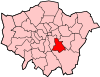
Attractions Horniman MuseumConstituencies Other topics People · Public art · SchoolsLondon Borough of Bromley Districts Anerley · Beckenham · Bickley · Biggin Hill · Bromley · Bromley Common · Chislehurst · Downe · Elmstead · Farnborough · Hayes · Keston · Leaves Green · Mottingham · Orpington · Penge · Petts Wood · Pratt's Bottom · Shortlands · Southborough · St Mary Cray · St Paul's Cray · West Wickham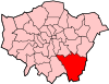
Attractions Bromley Museum · Chislehurst Caves · Churchill Theatre · Crofton Roman Villa · Crystal Palace · Down House · Betts ParkConstituencies Other topics Categories:- Districts of London
- Districts of Lewisham


Wikimedia Foundation. 2010.