- Mottingham
-
Coordinates: 51°26′01″N 0°02′11″E / 51.4337°N 0.0365°E
Mottingham 
 Mottingham
Mottingham shown within Greater LondonOS grid reference TQ415725 - Charing Cross 9 mi (14.5 km) NW London borough Bromley Lewisham Greenwich Ceremonial county Greater London Region London Country England Sovereign state United Kingdom Post town LONDON Postcode district SE9 Dialling code 020 Police Metropolitan Fire London Ambulance London EU Parliament London UK Parliament Bromley and Chislehurst Lewisham East Eltham London Assembly Bexley and Bromley Greenwich and Lewisham List of places: UK • England • London Mottingham is a district of south London, England; located at the convergence of the London Borough of Bromley, the London Borough of Lewisham and the London Borough of Greenwich. It is situated 9 miles (14.5 km) southeast of Charing Cross.
Contents
Etymology
The earliest records of Mottingham are from 862 AD when it was recorded as Modingahema, which means the land of Moda's people and is commonly interpreted as - "the proud place".
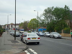 Mottingham Road,the main road through the village
History
Mottingham was originally a hamlet in Eltham parish, in the Blackheath hundred of Kent. In 1840 it was included in the Metropolitan Police District by the Metropolitan Police Act 1839. A key year in the history of Mottingham was 1866, when the area became connected to the railway system with the construction of Mottingham station (then known as Eltham station). Also in 1866, Mottingham received separate civil parish status,[1] thus separating itself from Eltham. In 1881 the parish had a population of 779 and covered an area of 642 acres (2.60 km2).
When the County of London was created in 1889, Mottingham was excluded from the new county and now formed a protrusion of Kent, bordering London to the west, north and east. From 1894 to 1934 it formed a detached part of the Bromley Rural District.[2] In 1931 the parish had a population of 2,120. In 1934 the rural district and the Mottingham civil parish were abolished and the area was transferred to Chislehurst and Sidcup Urban District.[3] In 1965 the urban district was abolished and the area was transferred from Kent to Greater London, to form part of the London Borough of Bromley. The boundary between Bromley and Greenwich,[4] and between Bromley and Lewisham,[5] around Mottingham was adjusted in 1994.
The first church in Mottingham was St Andrews Church on Court Road and was established in 1884, which further helped establish Mottingham as separate from Eltham. A local landmark is Eltham College, a private school founded in 1842 as the London Missionary Society's School for the Sons of Missionaries, which moved to its present site in Mottingham in 1912. The famous cricketer, Dr W. G. Grace lived in retirement for some years in Mottingham and a blue plaque marks his residence, 'Fairmount' in Mottingham Lane, where he died on 23 October 1915. He was buried in Beckenham Crematorium.
Notable residents
- Anton Ferdinand
- W.G. Grace
- Carl Leaburn
- Jim Staples
- Alex Walkinshaw
- Kate Winslet
- Billy Bonds
- Dionne Bromfield
Transport and locale
The buses 126, 124, 273, 161, 284, 314, and N136 serve Mottingham making it a very accessible area in relation to its size.
- Nearest places
- Nearest railway stations
References
- ^ Vision of Britain - Mottingham CP (historic map)
- ^ Vision of Britain - Bromley RD (historic map)
- ^ Vision of Britain - Chislehurst and Sidcup UD (historic map)
- ^ Office of Public Sector Information - Bromley and Greenwich (London Borough Boundaries) Order 1993
- ^ Office of Public Sector Information - Bromley and Lewisham (London Borough Boundaries) Order 1993
London Borough of Bromley Districts Anerley · Beckenham · Bickley · Biggin Hill · Bromley · Bromley Common · Chislehurst · Downe · Elmstead · Farnborough · Hayes · Keston · Leaves Green · Mottingham · Orpington · Penge · Petts Wood · Pratt's Bottom · Shortlands · Southborough · St Mary Cray · St Paul's Cray · West Wickham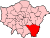
Attractions Bromley Museum · Chislehurst Caves · Churchill Theatre · Crofton Roman Villa · Crystal Palace · Down House · Betts ParkConstituencies Other topics Parks and open spaces in Bromley London Borough of Lewisham Districts Blackheath · Brockley · Catford · Deptford · Downham · Forest Hill · Grove Park · Hither Green · Honor Oak · Lee · Lewisham · Mottingham · New Cross · St Johns · Sydenham (Hill)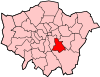
Attractions Horniman MuseumConstituencies Other topics People · Public art · SchoolsParks and open spaces in Lewisham London Borough of Greenwich Districts Abbey Wood · Blackheath · Charlton · Deptford · Eltham · Greenwich · Kidbrooke · Mottingham · New Eltham · Plumstead · Shooter's Hill · Thamesmead · Westcombe Park · Woolwich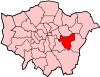
Attractions The O2 arena (formerly the Millennium Dome) · The Royal Artillery Museum · Cutty Sark · National Maritime Museum · Eltham Palace · Greenwich Hospital · Royal ObservatoryStreet markets Parks and open spaces Bostall Heath and WoodsConstituencies Other topics People · Public art · SchoolsCategories:- Districts of Bromley
- Districts of Greenwich
- Districts of London


Wikimedia Foundation. 2010.