- A2212 road
-
A2212 road
Route information Length: 3.6 mi (5.8 km) Major junctions North end: Lee Green  A20 road
 A205 road
 A21 road
South end: Bromley Location Primary
destinations:Bromley Road network Roads in the United Kingdom
Motorways • A and B road zones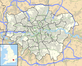
 Greater London map showing location of the A2212 road junctions - north to south: A20 Junction at Lee Green, A205 Junction, Grove Park junction, Plaistow Green junction and A21 Junction in Bromley.
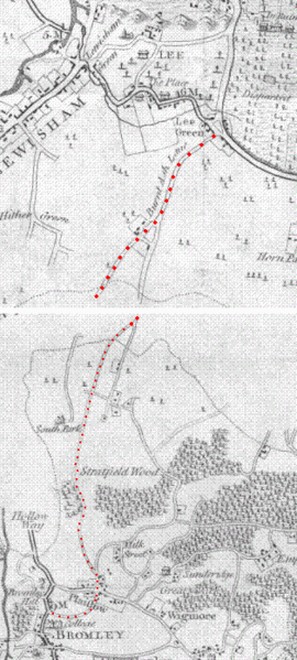 This image shows sections of two maps from a book published in 1797 showing the road running from Lee Green to Bromley, named "Burnt Ash Lane" at its northern part near Lee Green (north is top right)
The A2212 road is a 4-digit, non-primary A road in southeast London, England; it is 5.7 km (3.5 mi) long and runs in a north to south direction from Lee Green, to Bromley passing through Grove Park, Downham, Plaistow and Sundridge. Bromley is the only one of these places which is a primary destination.
The road begins at Lee Green cross roads coming off the A20 road, ends in Bromley joining the A21 road, and is crossed by the A205 road about 1.2 km (0.75 mi) south of Lee Green. Grove Park traffic lights are approximately the mid point of the road about 2.8 km (1.7 mi) from both Bromley and Lee Green.
In total the road has eight names in different places, approximately half the length of the road has "Burnt Ash" used within its name. From north to south the different names are:
- Burnt Ash Road
- Burnt Ash Hill
- Baring Road
- Burnt Ash Lane
- (Plaistow Green Roundabout)
- Nichol Lane
- College Road
- Cambridge Road
- Paxton Road
- College Road
The road is in two London boroughs and two postcode districts. At the northern end 3.4 km of the route called Burnt Ash Hill, Burnt Ash Road and Baring Road, is within the London Borough of Lewisham and the SE12
postcode district. At the southern end 2.3 km of the route, Burnt Ash Lane, College Road and Plaistow Green roundabout are within the London Borough of Bromley and the BR1
postcode district.
Contents
Public transport
London buses
There are two bus stations close to the A2212 road. Grove Park bus station on the west side of Baring Road in Grove Park north of the traffic lights. Bromley North bus station is on station road in Bromley alongside Bromley North railway station about
150 m (500 ft) east of College Road traffic lights the southern end of the A2212 road.The following London buses travel along parts of the A2212.
124 • 126 • 136 • 181 • 202 • 261 • 273 • 284 • 314 • 336 • N136
The 261 bus uses the whole length of the road, on its route from Lewisham through Lee and Grove Park to Bromley or Locksbottom. The 202 bus uses Burnt Ash Road and Burnt Ash Hill the northern part of the A2212 on its route from Blackheath through Lee and Hither Green to Catford. The 273 bus journey joins the road twice on Burnt Ash Hill and Baring Road using smaller side roads in between on its route from Lewisham through Hither Green, Lee, Grove Park, Chinbrook, Mottingham, Chislehurst to Petts Wood. The 126 bus uses the southern half of the A2212, Burnt Ash Lane and College Road on its route from Eltham through Mottingham, Chinbrook, Grove Park, Plaistow, and Sundridge to Bromley; part its route is identical to part of the 261 bus route. The buses 314 and 336 use College Road the southern most part of the A2212 between Plaistow Green and Bromley. The buses 124, 181, 273, 284 and N36 stop at Grove Park bus station and use a small part of Baring Road there. There are also several other buses that stop at both ends of the A2212 at Lee Green and Bromley that do not use the road, and the 160 bus travels along the A205 road and stops at its junction with the A2212.
All buses on different sections Section Buses Lee Green to St. Mildreds Road (A205) 202, 261, 273 St. Mildreds Road (A205) to Grove Park 261, 273 Baring Road, Grove Park 124, 126, 136, 181, 261, 273, 284, N36 Grove Park to Plaistow Green 126, 261 Plaistow Green to Bromley 126, 261, 314, 336 Railway transport
There are four railway stations and three railway lines near the A2212 road. Lee and Grove park railway stations have their main entrance on the road while those of Sundridge Park and Bromley North stations are both within 200 m of it; all four stations are located east of the road. Lee station the northern most of these stations is on the Dartford loop line, here the A2212 passes under a railway bridge where the A2212's name changes from Burnt Ash Road to the north and Burnt Ash Hill to the South. Grove Park station is at the mid point of the A2212 and is on the Southeast Main Line and the Bromley North Line.
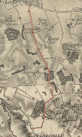
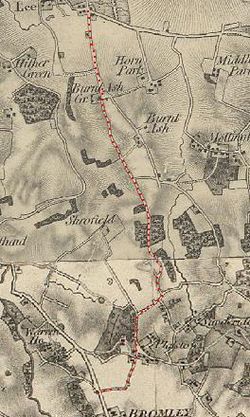 Section of OS map published in 1841 showing Burnt Ash, now the A2212 road, and the surrounding area
Coordinates
Coordinates of junctions
- Lee Green (A2212 - A20 junction): 51°27′23″N 0°00′41″E / 51.4565°N 0.0115°E
- St. Mildreds Road (A2212 - A205 junction): 51°26′46″N 0°00′51″E / 51.4462°N 0.0142°E
- Grove Park: 51°25′53″N 0°01′16″E / 51.4313°N 0.0210°ECoordinates: 51°25′53″N 0°01′16″E / 51.4313°N 0.0210°E
- Plaistow Green: 51°24′52″N 0°01′04″E / 51.4145°N 0.0178°E
- Bromley (A2212 - A21 junction): 51°24′32″N 0°00′51″E / 51.4090°N 0.0142°E
A roads in Zone 2 of the Great Britain road numbering scheme  Categories:
- Roads in England
- Transport in Lewisham
- Transport in Bromley


Wikimedia Foundation. 2010.