- Nakusp, British Columbia
-
Village of Nakusp — Village — Location of Nakusp in British Columbia
 Village of Nakusp
Coordinates: 50°14′36″N 117°48′1″W / 50.24333°N 117.80028°W Country  Canada
Province  British Columbia
Region Arrow Lakes, West Kootenay Regional district Central Kootenay Founded 1892 Incorporated 1964 Government - Governing body Nakusp Village Council - Mayor Karen Hamling Area - Total 7.42 km2 (2.9 sq mi) Elevation 457.2 m (1,500 ft) Population (2006) - Total 1,524 Time zone PST (UTC-8) Highways 6, 23 Website Village of Nakusp The Village of Nakusp (
 /nəˈkʌsp/) is a small community located on the shores of Upper Arrow Lake, a portion of the Columbia River, in the West Kootenay region of British Columbia. The town has a population of around 1,800, and it is known primarily for its nearby hot springs, which are a popular destination for tourists, as well as its picturesque mountain lakeside setting.
Contents
Services
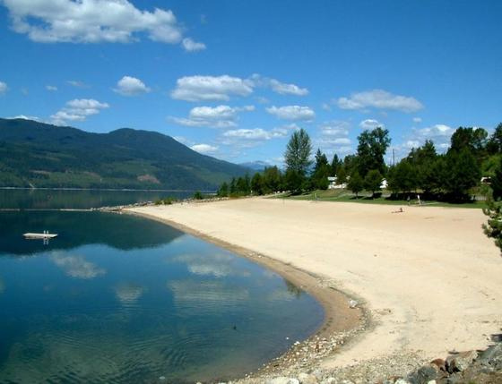
 Nakusp beach
Nakusp has a recreational centre that consists of an ice rink, squash courts, curling rink and an auditorium as well as outdoor tennis courts and a soccer field. Arrow Lakes Hospital serves the village and surrounding communities. There is an elementary school, a high school, and a campus of Selkirk College. The schools are part of School District 10 Arrow Lakes which has its board office in Nakusp. The area also provides many opportunities for recreation, including the Summit Lake Ski Hill, a short drive out of town towards New Denver.
History
The area around Nakusp was occupied by aboriginal peoples from the Shuswap, Sinixt and Kutenai First Nations. In 1811, the first reported European explorer on the Arrow Lakes was Finan McDonald, an associate of David Thompson.[1]
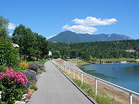 The waterfront walkway
European settlers arrived in 1890, and the settlement took shape in 1892 with opening of the first post office, the first store and the first sawmill. The nearest train link was the CPR at Revelstoke, so all goods were shipped to the fledgling port of Nakusp. In 1954, the last of the sternwheelers, the Minto was retired.
The construction of the Keenleyside Dam north of Castlegar in 1968 and the resulting rise of the lake level caused the rearrangement of the village and its waterfront.[2]
Mining was historically the most important industry in the area, but it was eclipsed by forestry which is today the major economic base of the village.[3]
Culture
Nakusp is home to a community radio station, CJHQ-FM.
In 2004 the village held its first Nakusp Music Fest, which has proved to be a popular attraction. Since then, the Festival has gotten bigger, supporting larger names. It is now known as the Interior's largest classic rock festival, although classic rock isn't the only genre being played.
Notable people
Brad Larsen is a professional ice hockey left winger who played several seasons in the National Hockey League.
Climate
Climate data for Nakusp Month Jan Feb Mar Apr May Jun Jul Aug Sep Oct Nov Dec Year Record high °C (°F) 13.3
(55.9)13
(55)17.5
(63.5)24.4
(75.9)33
(91)35.5
(95.9)37
(99)36.7
(98.1)33.3
(91.9)23
(73)18.3
(64.9)14.5
(58.1)37
(99)Average high °C (°F) −0.4
(31.3)2.1
(35.8)7.1
(44.8)13
(55)18.4
(65.1)22.1
(71.8)25.4
(77.7)24.7
(76.5)18.2
(64.8)11
(52)4.4
(39.9)0.2
(32.4)12.2 Average low °C (°F) −5.7
(21.7)−4.4
(24.1)−2.2
(28.0)1.4
(34.5)5.7
(42.3)9.3
(48.7)11.2
(52.2)10.9
(51.6)6.5
(43.7)2.6
(36.7)−1
(30)−4.4
(24.1)2.5 Record low °C (°F) −24.4
(−11.9)−24.4
(−11.9)−18.9
(−2.0)−9.4
(15.1)−3.9
(25.0)−1.1
(30.0)1.7
(35.1)0.6
(33.1)−6.5
(20.3)−11
(12)−20
(−4)−27.8
(−18.0)−27.8
(−18.0)Precipitation mm (inches) 101.2
(3.984)74.7
(2.941)52.3
(2.059)51.1
(2.012)61.9
(2.437)77.5
(3.051)59.3
(2.335)58.3
(2.295)56.5
(2.224)56.8
(2.236)88.6
(3.488)103.9
(4.091)842
(33.15)Source: Environment Canada[4] Notes
- ^ http://www.nakusp.com/siteengine/activepage.asp?PageID=3 Village of Nakusp History
- ^ Wilson, J.W. (1973). People in the Way. Toronto, ON: University of Toronto Press.
- ^ http://www.nakusp.com Village of Nakusp History
- ^ Environment Canada—Canadian Climate Normals 1971–2000, accessed 26 March 2010
External links
Subdivisions of British ColumbiaSubdivisions Regions · Regional districts · Forest Regions and Forest Districts · School districts · Land DistrictsSettlements Urban centres Villages Alert Bay · Anmore · Ashcroft · Belcarra · Burns Lake · Cache Creek · Canal Flats · Chase · Clinton · Fraser Lake · Fruitvale · Gold River · Granisle · Harrison Hot Springs · Hazelton · Kaslo · Keremeos · Lions Bay · Lumby · Lytton · Masset · McBride · Midway · Montrose · Nakusp · New Denver · Pemberton · Port Alice · Port Clements · Pouce Coupe · Queen Charlotte · Radium Hot Springs · Salmo · Sayward · Silverton · Slocan · Tahsis · Telkwa · Valemount · Warfield · Zeballos Category:British Columbia ·
  Portal:British Columbia ·
  WikiProject:British Columbia
Coordinates: 50°14′36.1″N 117°48′00.6″W / 50.243361°N 117.800167°W
Categories:- Villages in British Columbia
- Populated places in the West Kootenay
- Columbia Country
- Arrow Lakes
- Hot springs of British Columbia
- Populated places on the Columbia River


Wikimedia Foundation. 2010.