- Alert Bay, British Columbia
Infobox Settlement
official_name = Village of Alert Bay
other_name =
native_name =
nickname =
settlement_type = Village
motto =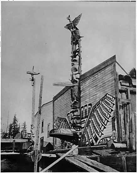
imagesize = 180px
image_caption = Totem poles in front of homes in Alert Bay in the 1900s
flag_size =
image_
seal_size =
image_shield =
shield_size =
city_logo =
citylogo_size =
mapsize =
map_caption =
mapsize1 =
map_caption1 =
image_dot_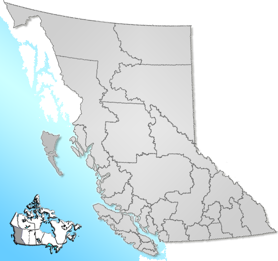
dot_mapsize = 220px
dot_map_caption = Location of Alert Bay inBritish Columbia
dot_x = 82 |dot_y = 160
pushpin_
pushpin_label_position =
pushpin_map_caption =
pushpin_mapsize =
subdivision_type = Country
subdivision_name = CAN
subdivision_type1 = Province
subdivision_name1 = BC
subdivision_type2 = Region
subdivision_name2 = Central Coast
subdivision_type3 = Regional district
subdivision_name3 = Mount Waddington
subdivision_type4 =
subdivision_name4 =
government_footnotes =
government_type =
leader_title = Governing body
leader_name = Alert Bay Village Council
leader_title1 =
leader_name1 =
leader_title2 =
leader_name2 =
leader_title3 =
leader_name3 =
leader_title4 =
leader_name4 =
established_title =
established_date =
established_title2 = Incorporated
established_date2 = 1946
established_title3 =
established_date3 =
area_magnitude =
unit_pref =
area_footnotes =
area_total_km2 = 1.78
area_land_km2 =
area_water_km2 =
area_total_sq_mi =
area_land_sq_mi =
area_water_sq_mi =
area_water_percent =
area_urban_km2 =
area_urban_sq_mi =
area_metro_km2 =
area_metro_sq_mi =
area_blank1_title =
area_blank1_km2 =
area_blank1_sq_mi =
population_as_of = 2007
population_footnotes =
population_note =
population_total = 584
population_density_km2 =
population_density_sq_mi =
population_metro =
population_density_metro_km2 =
population_density_metro_sq_mi =
population_urban =
population_density_urban_km2 =
population_density_urban_sq_mi =
population_blank1_title =
population_blank1 =
population_density_blank1_km2 =
population_density_blank1_sq_mi =
timezone = PST
utc_offset = -8
timezone_DST =
utc_offset_DST =
latd= 50|latm= 34|lats= 57|latNS=N
longd= 126|longm= 55|longs= 31|longEW=W
elevation_footnotes =
elevation_m = 30
elevation_ft =
postal_code_type =
postal_code =
area_code =
blank_name = Highways
blank_info = Sointula ferry
Port McNeil ferry
blank1_name = Waterways
blank1_info =Johnstone Strait ,Broughton Strait ,Cormorant Channel
website = [http://www.village.alertbay.bc.ca/ Village of Alert Bay]
footnotes = :"This article is for the community in the Queen Charlotte Strait region of British Columbia, and should not be confused with the community ofAlert, Nunavut .Alert Bay (2006 Population 556) is a small community on Cormorant Island,British Columbia ,Canada . Cormorant Island consists primarily of the village of Alert Bay.Approximately half of the population is
First Nations people. The village is inKwakwaka'wakw territory.There is one
automatic teller machine , one grocery store and one museum in Alert Bay. The town is served by a public-use airport, theAlert Bay Airport .In 1921, the Federal Government, in an effort to stop the potlatch under Section 116 of the
Indian Act , pillaged the community of such items as wooden masks, copper shields, andpotlatch -dance regalia, some of which were later placed in the U’mista Cultural Centre in the village. During the 70s and 80s, the population regained their possessions after long negotiations. The artifacts housed in the cultural centre were given back to the village population as well as items stored in other museums. [cite web | title=Dancing around Alert Bay | work=Straight.com | url=http://www.straight.com/content.cfm?id=18111 | accessdate=2006-06-01]Alert Bay is also home to the world's tallest totem pole.
Geology
Volcanic features in the geography around Alert Bay are part of the
Alert Bay Volcanic Belt . It appears to have been active inPliocene andPleistocene times. NoHolocene eruptions are known, and volcanic activity in the belt has likely ceased.ee also
*
Musgamagw Tsawataineuk Tribal Council
*‘Namgis First Nation
*Alert Bay Volcanic Belt References
External links
* [http://www.bluebookofboats.com/Cruisingdestinations/Alaska3.htm/ How to get to Alert Bay]
* [http://www.village.alertbay.bc.ca/ Village of Alert Bay]
* [http://www12.statcan.ca/english/census06/data/popdwell/Table.cfm?T=301&SR=57&S=1&O=A&RPP=100&SRCH=1 Alert Bay's Census Profile]
Wikimedia Foundation. 2010.