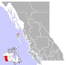
- Masset, British Columbia
-
Village of Masset — Village — Old Massett and its impressive collection of longhouses and totem poles. Location of Masset in British Columbia Coordinates: 54°01′22″N 132°05′56″W / 54.02278°N 132.09889°W Country  Canada
Province  British Columbia
Region Haida Gwaii Regional district Skeena-Queen Charlotte Incorporated 1961 Government – Governing body Masset Village Council – Mayor Barry Pages Area – Total 19.45 km2 (7.5 sq mi) Elevation 10 m (33 ft) Population (2006) – Total 940 Time zone PST (UTC-8) Highways 16 Waterways Dixon Entrance Masset (pronounced /ˈmæsɨt/, formerly Massett[1]) is a village in Haida Gwaii (formerly the Queen Charlotte Islands) in British Columbia, Canada. It is located on the northern coast of Graham Island, the largest island in the archipelago, and is approximately 50 km (31 mi) west of mainland British Columbia. It is the western terminus of the Yellowhead Highway. During the Maritime Fur Trade of the early 19th century Masset was a key trading site.
Contents
Name
The name Masset was a gift from the Captain of a Spanish vessel that was repaired with the assistance of the Haida citizens of Atewaas, Kayung and Jaaguhl. These three villages accepted the gift and adopted the name Masset to commemorate what might be the first ever contact between Europeans and the Haida.
During the early years of Canadian colonization the name Masset and the post office were adopted by the former Reverend Charles Harrison as part of his scheme to sell land.
The name Masset is currently in use by the Village of Masset, a municipality under Canada legislation and the Village of Old Massett, the original recipient of the name and a village under the Constitution of the Haida Nation.
According to Walbran[2]:323 Masset came from the Haida word, Masst or large island. Captain Douglas, on his second visit from Nootka Sound aboard the Iphigenia on June 19, 1789 named the bay leading to the inlet McIntyre's Bay. This name was used on the charts of Dixon and Meares. The American traders called the inlet, Hancock's River as shown in Ingraham's chart of 1792 after the American brig Hancock. In 1853 H.N. Knox of the Royal Navy, mate on HMS Virago, did a sketch survey of the harbour when the name Masset was adopted by the British. A survey was made in 1907 by Captain Learmouth on HMS Egeria.
Military base
A FRD-10 based military intelligence gathering station, CFS Masset, that was key in monitoring communications in the northern portions of the former Soviet Union during the Cold War is located just outside Masset, near the northern tip of Graham island.
Notable people from Masset
- Guujaaw (wood carver, musician, traditional medicine practitioner and political activist)
- Michael Nicoll Yahgulanaas (Haida manga artist)
- Robert Davidson (artist)
- Florence Davidson (artist)
- Reg Davidson (carver)
Climate
The climate, moderated by a warm Pacific current from Japan, is generally mild with no extremes in temperature. Annual temperature varies only 20 degrees Celsius but is variable and unpredictable - even within a 24-hour period. This explains the often heard[according to whom?] maxim, "If you don’t like the weather, wait 20 minutes." Average rainfall is 150 centimeters,[dubious ] snowfall 28 centimeters and there is generally a breeze, most often out of the southeast.
Summer temperatures are in the 15 degrees Celsius to 20 degrees Celsius range and the days are long - May, June, July boasting 18 to 20 hours of daylight. August and May general have the most sun but there is a fair degree of rain throughout the summer months. Winter months are mild with temperatures in the 0 - 8 degrees Celsius range and while precipitation is usually in the form of rain there can be some snowfall. Conditions can become severe without warning and Masset has registered wind gusts to 160 km/h (100 mph).
See also
References
- ^ "Masset". BC Geographical Names. http://apps.gov.bc.ca/pub/bcgnws/names/35755.html.
- ^ Walbran, Captain John T. (1971), British Columbia Place Names, Their Origin and History (Facsimile reprint of 1909 ed.), Vancouver/Toronto: Douglas & McIntyre, ISBN 0-88894-143-9, http://www.nosracines.ca/e/toc.aspx?id=3545
 Subdivisions of British Columbia
Subdivisions Regions · Regional districts · Forest Regions and Forest Districts · School districts · Land DistrictsSettlements Urban centres Villages Alert Bay · Anmore · Ashcroft · Belcarra · Burns Lake · Cache Creek · Canal Flats · Chase · Clinton · Fraser Lake · Fruitvale · Gold River · Granisle · Harrison Hot Springs · Hazelton · Kaslo · Keremeos · Lions Bay · Lumby · Lytton · Masset · McBride · Midway · Montrose · Nakusp · New Denver · Pemberton · Port Alice · Port Clements · Pouce Coupe · Queen Charlotte · Radium Hot Springs · Salmo · Sayward · Silverton · Slocan · Tahsis · Telkwa · Valemount · Warfield · ZeballosCategories:- Villages in British Columbia
- Populated places in Haida Gwaii
- Haida
- Graham Island
- Hudson's Bay Company trading posts
- Canadian Forces bases in British Columbia
Wikimedia Foundation. 2010.


