- Dallow
-
Coordinates: 51°52′55″N 0°26′06″W / 51.882°N 0.435°W
Dallow 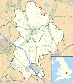
 Dallow
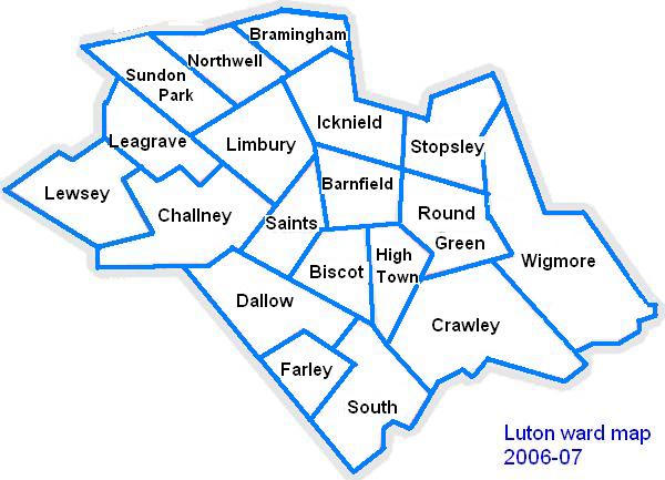
Dallow shown within BedfordshirePopulation 13,154 (est.).[1] OS grid reference TL059227 Unitary authority Luton Ceremonial county Bedfordshire Region East Country England Sovereign state United Kingdom Post town LUTON Postcode district LU1 Dialling code 01582 Police Bedfordshire Fire Bedfordshire and Luton Ambulance East of England EU Parliament East of England UK Parliament Luton South List of places: UK • England • Bedfordshire The Dallow ward of Luton is a large area about one mile west of the town centre which has Dallow Road as its main artery. The recreation ground at the intersection of Brantwood Road and the open wooded hills beginning at Runley Road mark the boundaries of the area.
Some buildings in the area are to become part of Luton's Rothesay Preservation Area. The land was originally farmland and nearly all the buildings date from the late 19th century through to the 1920s. New enterprises such as Laporte's Chemical Works, the CWS cocoa works, Brown's Timberyard and the Davis gas stove factory were opened and the surrounding area was completed by 1920.
The Edwardian semi-detached houses of Brantwood Road, facing the park have an art deco style whilst those in Ashburnham Road include ornate balconies. The name of Rothesay is part of Luton's heritage, Rothesay Castle being the seat of the Earls and Marquesses of Bute, who stayed at Luton Hoo for many years during the eighteenth century and were also influential landowners.
Contents
Politics
Dallow is represented by Cllr Mohammed Ashraf (Labour), Cllr Mohammed Farooq (Labour) and Cllr Tafheen Sharif (Labour).
The ward forms part of the parliamentary constituency of Luton South, and the MP is Gavin Shuker (Labour). Dallow is within the East of England (European Parliament constituency). :)
 Map of Luton showing Dallow
Local Attractions
Key 
Abbey/Priory/Cathedral 
Accessible open space 
Amusement/Theme Park 
Castle 
Country Park 
English Heritage 
Forestry Commission 
Heritage railway 
Historic House 

Museum (free/not free) 
National Trust 
Zoo - Dunstable Downs
 Chiltern Hills
- Leagrave Park
- Leighton Buzzard Light Railway
 Luton Museum & Art Gallery
- the hat Factory
 Luton Hoo
- Mossman Collection
- Someries castle
- Stockwood Craft Museum
- Stockwood Park
- Wardown Park
- Waulud's Bank
- Whipsnade Tree Cathedral
 Whipsnade Wildlife Park
- Woodside Farm and Wildfowl Park
- Wrest Park Gardens
Local Newspapers
Two weekly newspapers are delivered free to all the houses in Dallow. However they are not specific to Dallow. They are:
- Herald and Post - Delivered every Thursday
- Luton on Sunday- Delivered every Sunday
References
The Town of Luton in Bedfordshire, England Places within Luton Barnfield · Biscot · Bramingham · Bury Park · Bushmead · Butterfield Green · Capability Green · Challney · Crawley Green · Farley Hill · Dallow · High Town · Hockwell Ring · Icknield · Leagrave · Lewsey · Limbury-cum-Biscot · Marsh Farm · New Town · Northwell · Putteridge · Round Green · Saints · South ward · Stopsley · Sundon Park · Warden Hills · Wigmore
Amenities Kenilworth Road · Luton Museum · The Mall (Luton) · Stockwood Park · Wardown Park · Waulud's Bank
Education Ashcroft High School · Barnfield College · Barnfield South Academy · Barnfield West Academy · University of Bedfordshire · Cardinal Newman · Challney High School For Boys · Challney High School For Girls · Denbigh High School · Icknield High School · Lea Manor High School · Lealands High School · Luton Sixth Form College · Putteridge High School · Rabia School · Stopsley High School · Woodlands Secondary School
Media Places within Luton Barnfield · Biscot · Bramingham · Bury Park · Bushmead · Butterfield Green · Capability Green · Challney · Crawley Green · Farley Hill · Dallow · High Town · Hockwell Ring · Icknield · Leagrave · Lewsey · Limbury-cum-Biscot · Marsh Farm · New Town · Northwell · Putteridge · Round Green · Saints · South ward · Stopsley · Sundon Park · Warden Hills · Wigmore
Categories:- Wards of Luton
- Bedfordshire geography stubs

Wikimedia Foundation. 2010.