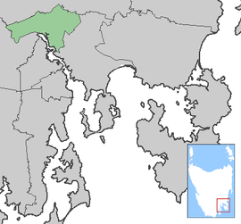
Brighton Council

Brighton Council
Brighton Council
Tasmania
LGA Tas SE Brighton.png
Brighton Council
Population: 16,358[1]
Established: 1863
Coordinates: 42°43′14″S 147°17′40″E / 42.72056°S 147.29444°E / -42.72056; 147.29444Coordinates: 42°43′14″S 147°17′40″E / 42.72056°S 147.29444°E / -42.72056; 147.29444
Area: 168 km² (64.9 sq mi)
Mayor: Tony Foster
Council Seat: Brighton
Region: Brighton/Bridgewater
State District: Lyons
Federal Division: Lyons
Website: http://www.brighton.tas.gov.au
LGAs around Brighton Council:
Southern Midlands Southern Midlands Southern Midlands
Derwent Valley Brighton Council Clarence
Derwent Valley Glenorchy Clarence

The Brighton Council or Municipality of Brighton is a Local Government Area of Tasmania. It in based in the town of Brighton, and covers the towns of Pontville and Tea Tree. It also covers the far northern Hobart suburbs of Bridgewater, Gagebrook, Honeywood and Old Beach.

Brighton Council has one of the highest birth rate in all of Australia. The Total Fertility Rate was 2.64 in 2001 and 2.60 in 2006 according to the birth rate and fertility rate in Australia site.

References

  1. ^ Australian Bureau of Statistics (31 March 2011). "3218.0 - Regional Population Growth, Australia, 2009-10". http://www.abs.gov.au/AUSSTATS/abs@.nsf/DetailsPage/3218.02009-10?OpenDocument. Retrieved 23 August 2011.  Estimated resident population (ERP) at 30 June 2010.

External links


Wikimedia Foundation. 2010.

Игры ⚽ Нужна курсовая?

Look at other dictionaries:

  • Brighton Municipality — Municipality of Brighton Lage der Brighton Municipality in Tasmanien Gliederung …   Deutsch Wikipedia

  • Brighton, Tasmania — Infobox Australian Place | type = town name = Brighton state = tas loc x = loc y = coordinates = coord|42|41|46|S|147|15|17|E|display=inline,title caption = lga = Brighton Council postcode = 7030 pop = est = elevation= maxtemp = mintemp =… …   Wikipedia

  • Brighton and Hove local elections — Brighton Hove Council is elected every four years.Political controlLabour 1996 2003No overall control 2003 presentCouncil elections* Brighton Hove Council election, 1995 * Brighton Hove Council election, 1999 * Brighton Hove Council election,… …   Wikipedia

  • Brighton Hill — is a district of Basingstoke, England, that was formed around 1970 as part of the Town Centre Development Plan. The area is bounded to the west by the newer housing estate of Hatch Warren and by the A30. To the east of Brighton Hill, the Viables… …   Wikipedia

  • Brighton, Monroe County, New York — Brighton is also a town in Franklin County, New York, USA .Geobox Settlement name = Brighton native name = other name = other name1 = category = Town image size = image caption = flag size = symbol = symbol size = nickname = nickname1 = motto =… …   Wikipedia

  • Brighton, Franklin County, New York — Brighton is also a different town in Monroe County, New York. Brighton, New York   Town   Brighton Town Hall …   Wikipedia

  • Brighton railway works — was built in 1840 by the London and Brighton Railway in Brighton, England. History The London and Brighton Railway built one of the first ever railway owned locomotive construction and repair works on a site adjacent to the Brighton railway… …   Wikipedia

  • BRIGHTON — BRIGHTON, town on the south coast of England. Jews began to settle in Brighton in the middle of the 18th century. When the town became a fashionable resort, wealthy Jews flocked there, including the goldsmid family at the beginning of the 19th… …   Encyclopedia of Judaism

  • Brighton Football Club — were an Australian rules football club which played in the VFA. The club was based in the Melbourne suburb of Brighton and were nicknamed the Penguins. They wore maroon and gold guernseys before the club moved to Caulfield and later became the… …   Wikipedia

  • Brighton and Hove — City of Brighton and Hove   Unitary authority City   Brighton and Hove shown within England …   Wikipedia

Share the article and excerpts

Direct link
Do a right-click on the link above
and select “Copy Link”