- Narrabeen, New South Wales
-
Narrabeen
Sydney, New South Wales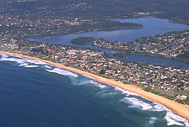
Population: 6,362[1] Postcode: 2101 Location: 23 km (14 mi) north of Sydney CBD LGA: Warringah Council State District: Pittwater, Wakehurst Federal Division: Mackellar Suburbs around Narrabeen: North Narrabeen Warriewood Narrabeen Lagoon Narrabeen Tasman Sea Wheeler Heights Collaroy Plateau Collaroy Narrabeen is a beachside suburb in northern Sydney, in the state of New South Wales, Australia. Narrabeen is located 23 kilometres north-east of the Sydney central business district, in the local government area of Warringah Council and is part of the Northern Beaches region.
Contents
History
There are a number of theories on the origins of the name "Narrabeen". One is that it derived from an Aboriginal word Narrabine meaning swan. Another involves Captain Henry Reynolds, a first fleeter who settled in the area with his family. They were killed during an attack by bushrangers and his homestead burned. The popular belief is that the location was then named after a young Aboriginal girl Narrabine, who lived near the lake, and who helped soldiers capture the escaped convicts involved in the massacre. Another theory is that on 26 January, 1801, Lieutenant James Grant and a party of three were walking to Pittwater, where they hoped to find a small rowing boat which had been stolen from Sydney.[citation needed] According to Grant's journal, at the mouth of the lagoon, he was confronted with the problem of crossing a stream, which the Aborigines told him was called Narrowbine . James Meehan mentions Narrowbang lagoon in his survey in 1815. It has also been suggested that the name could have been derived from Narrabin, a native plant growing near the lake entrance or narrow beans eaten by early explorers.[citation needed]
 Narrabeen, including Narrabeen Beach and the north and south divisions on either side of the lagoon.
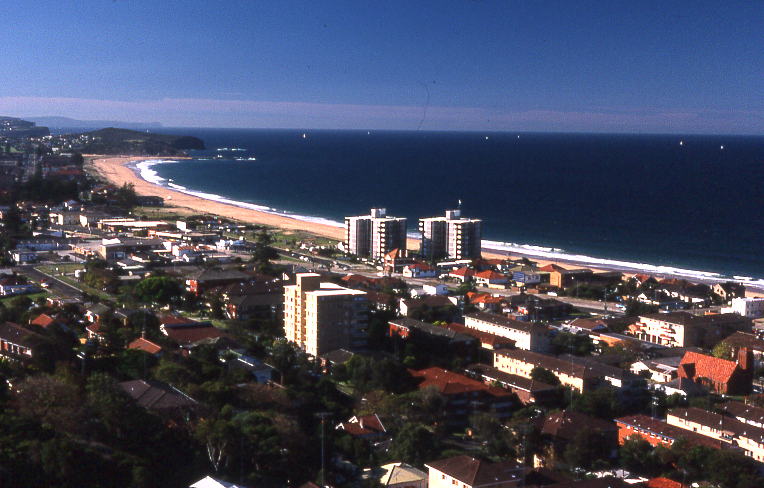
 View of Narrabeen from Collaroy Plateau
The first land grants were made to John Lees (40 acres), Philip Schaffer (50 acres), and James Wheeler (80 acres) all along the south bank of Mullet Creek. Alex Macdonald was granted 80 acres (320,000 m2) at the beach in 1815 and west of this land JT Collins had 93.5 acres (378,000 m2) by 1857.[2]
During the nineteenth century travellers had to ford the lake until 1880 when the first bridge opened. A second bridge at the mouth of the lagoon in Ocean Street was built in 1925. With the extension of the tram to Narrabeen in 1913 providing easier transport, the whole area around the lake became popular for holidays and camping. A large camping ground became established on the north shore of the lagoon. In 1946 the Wakehurst Parkway was opened to North Narrabeen connecting the whole Pittwater area directly to Frenchs Forest and Seaforth.
In December 2007, workmen excavating around the bus shelter near Octavia St. found the remains of a human body, which subsequent investigation revealed to be the remains of a 4000-year old Indigenous Australian who had died from a spear wound. He was named the "Narrabeen Man". His bones were to be buried in nearby Ku-ring-gai Chase National Park in 2008.[3]
Beaches
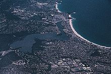
There are four beaches along the Narrabeen stretch of beach, North Narrabeen, Narrabeen, South Narrabeen and Collaroy beach. Although Collaroy is a separate suburb, its beach lies along the same stretch. All beaches have their own Surf Life Saving Club. There is also a lagoon at Narrabeen. Narrabeen beach is mentioned in the Beach Boys song Surfin' USA.[4]
Sport and recreation
The Sydney Institute of Sport is based in Narrabeen and has recently become the headquarters of the Manly-Warringah Sea Eagles rugby league club. North Narrabeen beach is commonly used for surfing competitions.
See also
 Media related to Narrabeen, New South Wales at Wikimedia Commons
References
- ^ Australian Bureau of Statistics (9 March 2006). "Narrabeen (State Suburb)". 2001 Census QuickStats. http://www.censusdata.abs.gov.au/ABSNavigation/prenav/LocationSearch?collection=Census&period=2001&areacode=SSC12666&producttype=QuickStats&breadcrumb=PL&action=401. Retrieved 2007-12-01.
- ^ The Book of Sydney Suburbs, Compiled by Frances Pollen, Angus & Robertson Publishers, 1990, Published in Australia ISBN 0-207-14495-8
- ^ Sabra Lane (2007-12-21). "Speared man unearthed after 4,000 years". ABC News. http://www.abc.net.au/news/stories/2007/12/21/2125690.htm. Retrieved 2007-12-31.
- ^ Surfin' USA Lyrics
External links
- Narrabeen, New South Wales is at coordinates 33°43′23″S 151°17′43″E / 33.72311°S 151.29521°ECoordinates: 33°43′23″S 151°17′43″E / 33.72311°S 151.29521°E
- Beach Location from SurfingAtlas.com
- - Narrabeen Beach Surf Life Saving Club
- Narrabeen - the Northern Beaches Tour - photographs and description.
- Narrabeen Head Aquatic Reserve
- Narrabeen History
Suburbs of Warringah Council | Northern Beaches | Sydney Allambie Heights · Beacon Hill · Belrose · Brookvale · Collaroy · Collaroy Plateau · Cottage Point · Cromer · Curl Curl · Davidson · Dee Why · Duffys Forest · Forestville · Frenchs Forest · Freshwater · Ingleside · Killarney Heights · Manly Vale · Narrabeen · Narraweena · North Balgowlah · North Curl Curl · North Manly · Oxford Falls · Queenscliff · Terrey Hills · Wheeler HeightsCategories:- Suburbs of Sydney
- Australian Aboriginal placenames
- Beaches of New South Wales


Wikimedia Foundation. 2010.