- North Narrabeen, New South Wales
-
North Narrabeen
Sydney, New South Wales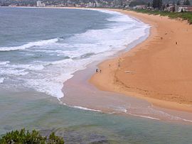
North Narrabeen beachPopulation: 5,279 [1] Postcode: 2101 Location: 25 km (16 mi) north of Sydney CBD LGA: Pittwater Council State District: Pittwater Federal Division: Mackellar Suburbs around North Narrabeen: Ingleside Warriewood Elanora Heights North Narrabeen Tasman Sea Narrabeen Lagoon Narrabeen North Narrabeen is a suburb in northern Sydney, in the state of New South Wales, Australia. North Narrabeen is located 25 kilometres north of the Sydney central business district, in the local government area of Pittwater Council. North Narrabeen is part of the Northern Beaches region.
North Narrabeen lies on the northern shores of Narrabeen lagoon, bounded by Warriewood to the north, Elanora Heights to the west and extends east to the ocean at Turrimetta Beach. Narrabeen is opposite on the southern shore of the lagoon. The beach at North Narrabeen is one of the eponymous northern beaches.[clarification needed]
Contents
Etymology
One theory on the origin of "Narrabeen" is that it is from an Aboriginal word Narrabine meaning many swans.[2] Other theories include that of Captain Henry Reynolds, a first fleeter settled in the area with his family and killed by bushrangers. The popular belief is that the location was then named after a young Aboriginal girl Narrabine, who lived near the lake, who helped soldiers capture the escaped convicts involved in the massacre. Another says that on 26 January 1801, Lieutenant James Grant and a party of three were walking to Pittwater, where they hoped to find a small rowing boat which had been stolen from Sydney. According to Grant's journal, he was confronted with the problem of crossing a stream at the mouth of the lagoon, which the Aborigines told him was called Narrowbine . James Meehan mentions Narrowbang lagoon in his survey in 1815. It has also been suggested that the name could have been derived from Narrabin, a native plant growing near the lake entrance or narrow beans eaten by early explorers. Another theory suggests that the area was named after Mr Greg Narra an early explorer who after being lost in the area survived on wild beans and would dub the plant Narra's Beans.
History
The first land grants were made to John Lees (40 acres), Philip Schaffer, (50 acres), and James Wheeler, (80 acres), along the south bank of Mullet Creek. Alex Macdonald was granted 80 acres (320,000 m2) at the beach in 1815 and west of this land JT Collins had 93.5 acres (378,000 m2) by 1857.
During the nineteenth century travellers had to ford the lake until 1880 when the first bridge opened. A second bridge at the mouth of the lagoon in Ocean Street was built in 1925. The extension of tram services to Narrabeen in 1913 provided easier transport, and the whole area around the lake became popular for holidays and camping. A large camping ground became established on the north shore of the lagoon. In 1946 the Wakehurst Parkway was opened to North Narrabeen connecting the whole Pittwater area directly to Frenchs Forest and Seaforth.
References
External links
- North Narrabeen, New South Wales is at coordinates 33°42′23″S 151°17′18″E / 33.70651°S 151.28836°ECoordinates: 33°42′23″S 151°17′18″E / 33.70651°S 151.28836°E
Suburbs and Localities of Pittwater Council | Northern Beaches | Sydney Akuna Bay · Avalon · Barrenjoey · Bayview · Bilgola · Church Point · Clareville · Coasters Retreat · Currawong Beach · Elanora Heights · Elvina Bay · Great Mackerel Beach · Ingleside · Lovett Bay · Mona Vale · Narrabeen · North Narabeen · Newport · Palm Beach · Scotland Island · Taylors Point · The Basin · Towlers Bay · Warriewood · Whale Beach
Categories:- Suburbs of Sydney
- Surfing locations in New South Wales
- Sydney geography stubs

Wikimedia Foundation. 2010.