- Church Point, New South Wales
-
Church Point
Sydney, New South Wales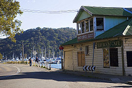
Church Point Post OfficePopulation: 1,153 [1] Postcode: 2105 Location: 32 km (20 mi) north of Sydney CBD LGA: Pittwater Council State District: Pittwater Federal Division: Mackellar Suburbs around Church Point: Elvina Bay Scotland Island Clareville Ku-ring-gai Chase National Park Church Point Newport Ingleside Bayview Mona Vale Church Point is a suburb in northern Sydney, in the state of New South Wales, Australia. Church Point is located 32 kilometres north of the Sydney central business district, in the local government area of Pittwater Council and is part of the Northern Beaches region.
Contents
History
Thomas Langford was the first settler in the area who acquired 40 acres (160,000 m2) in 1852. The area was originally known as Chapel Point because it was the site of a Wesleyan Chapel built in 1872 on land given by William Oliver.[2]
Transport
Pittwater Road is Church Point's main thoroughfare and ends in the suburb.
The Church Point Ferry Wharf is located in McCarrs Creek Road near the post office from where the Church Point Ferry service departs to Scotland Island, Pittwater Youth Hostel, Lovett Bay and Elvina Bay.
References
- ^ Australian Bureau of Statistics, 2006
- ^ The Book of Sydney Suburbs, Compiled by Frances Pollon, Angus & Robertson Publishers, 1990, Published in Australia ISBN 0-207-14495-8, page 62
External links
- Church Point, New South Wales is at coordinates 33°39′16″S 151°16′45″E / 33.65436°S 151.27905°ECoordinates: 33°39′16″S 151°16′45″E / 33.65436°S 151.27905°E
Suburbs and Localities of Pittwater Council | Northern Beaches | Sydney Akuna Bay · Avalon · Barrenjoey · Bayview · Bilgola · Church Point · Clareville · Coasters Retreat · Currawong Beach · Elanora Heights · Elvina Bay · Great Mackerel Beach · Ingleside · Lovett Bay · Mona Vale · Narrabeen · North Narabeen · Newport · Palm Beach · Scotland Island · Taylors Point · The Basin · Towlers Bay · Warriewood · Whale Beach
List of Sydney suburbs The Hawkesbury River region, New South Wales, Australia Islands of the Hawkesbury National parks Explorers of the region Bridges and ferries Hawkesbury River Railway Bridge · Mooney Mooney Bridge · Lower Portland Ferry · Sackville Ferry · Webbs Creek Ferry · Wisemans FerryAdjoining rivers, bays and creeks Shires City of Hawkesbury · Hornsby Shire · Pittwater Council · City of Gosford · The Hills Shire · City of PenrithEvents Categories:- Suburbs of Sydney
- Sydney geography stubs

Wikimedia Foundation. 2010.