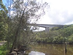
- Mooney Mooney Bridge
-
Mooney Mooney Bridge
Mooney Mooney BridgeOfficial name Mooney Mooney Creek Bridge Carries Road Traffic Crosses Mooney Mooney Creek Locale Central Coast Maintained by RTA Design Cantilever bridge Total length 480 m (1,575 ft) Width 27 m (89 ft) Height 75 m (246 ft) Longest span 220 m (722 ft) Opened December 1988 Mooney Mooney Creek Bridge is a twin cantilever bridge that spans Mooney Mooney Creek in Brisbane Water National Park on the Central Coast of New South Wales as part of the Sydney-Newcastle Freeway. It is the highest road bridge in Australia as measured from the road bed to the water 75 m (246 ft) below.[1] It was opened in December 1988 and is maintained by the Roads and Traffic Authority of New South Wales.[2]
The Sydney-Newcastle Freeway is the main road link between Sydney and the Central Coast, Newcastle, New South Wales and Hunter Valley. The only other road that links these regions is the Pacific Highway which from Cowan to Kariong follows a scenic winding route.[3]
Contents
Mooney Mooney Bridge was built by Enpro Constructions out of prestressed concrete. It has three spans. The span at the western end of the bridge is 135 metres long, the main span is 220 m (722 ft) long and the eastern span is 131 m (430 ft) long.[2]
The design has been said to demonstrate how good engineering design and good aesthetics are synonymous, and has been used as a standard in the design of bridges throughout New South Wales. They employ a two rail parapet which optimises views of the landscape. The bridges were designed with the natural surroundings in mind and form a simple uncluttered shape so not to detract from the natural bushland of the National Park. The three span haunched girders on the bridge were critical to this as were the multiple piers that provide character and strength.[4]
The bridge is the second crossing of the creek in the area, with the original two lane truss bridge that still services Pacific Highway traffic not far downstream of the modern bridge.
Incidents
The Mooney Mooney Bridge has been the site of several accidents, resulting in the Sydney-Newcastle Freeway being closed to traffic and causing delays. Some of these accidents have prompted debate on whether a new road should be built to supplement the existing freeway.[5]
On 23 October 2004 a semi-trailer's brakes failed coming down the Freeway and caused a pile-up involving 35 vehicles that had slowed down as a result of a car accident on the other side of the bridge. This accident resulted in the death of a woman.[6] On 12 February 2007 another accident occurred when a truck was travelling down the freeway and lost control approaching the bridge, smashing through a guard rail and plunging 30 metres down an embankment at the side of the bridge.[7]
The Mooney Mooney Bridge, because of its height, has been susceptible in the past to people committing suicide. As a result, a fence was erected along the side of the bridge to prevent people jumping off. This fence was erected in 2003 and cost A$1,000,000.[8]
References
- ^ "hawkesburyriver.org.au". History on the Hawksbury River. http://www.hawkesburyriver.org.au/History.htm. Retrieved 12 February 2007.
- ^ a b Mooney Mooney Bridge (1986) at Structurae. Retrieved on 13 February 2007.
- ^ "ozroads.com.au". Ozroads: NSW State Route 83. http://www.ozroads.com.au/NSW/RouteNumbering/State%20Routes/83/sr83.htm. Retrieved 13 February 2007.
- ^ "rta.nsw.gov.au". Roads and Traffic Authority: Bridge Aesthetics - Design guidelines to improve the appearance of bridges in NSW (PDF File). http://www.rta.nsw.gov.au/constructionmaintenance/downloads/urbandesign/rta_bridges_final_1.pdf. Retrieved 14 February 2007.
- ^ "expressadvocate.com.au". Central Coast Express Advocate - Breaking News: Double Vision. http://www.expressadvocate.com.au/article/2007/01/25/2738_news.html. Retrieved 13 February 2007.[dead link]
- ^ "Sydney Morning Herald: F3 reopens after fatal smash". The Sydney Morning Herald. 23 October 2004. http://www.smh.com.au/articles/2004/10/23/1098474908951.html?from=storylhs. Retrieved 13 February 2007.
- ^ "police.nsw.gov.au". New South Wales Police Online - Latest Media Information: Truck Crash - Mooney Mooney Bridge. 23 October 2004. http://www.smh.com.au/articles/2004/10/23/1098474908951.html?from=storylhs. Retrieved 13 February 2007.
- ^ "dadsindistress.asn.au". Dads in Distress: What's it cost to save a man's life?. http://www.dadsindistress.asn.au/helpus.html. Retrieved 13 February 2007.
External links
- Roads and Traffic Authority
- Mooney Mooney Bridge is at coordinates 33°25′59″S 151°15′14″E / 33.433°S 151.254°ECoordinates: 33°25′59″S 151°15′14″E / 33.433°S 151.254°E
The Hawkesbury River region, New South Wales, Australia Islands of the Hawkesbury National parks Explorers of the region Bridges and ferries Hawkesbury River Railway Bridge · Mooney Mooney Bridge · Lower Portland Ferry · Sackville Ferry · Webbs Creek Ferry · Wisemans FerryAdjoining rivers, bays and creeks Shires City of Hawkesbury · Hornsby Shire · Pittwater Council · City of Gosford · The Hills Shire · City of PenrithEvents Categories:- Bridges in New South Wales
- Bridges completed in 1988
- Central Coast, New South Wales
Wikimedia Foundation. 2010.

