- Mount Umunhum
-
Mount Umunhum 
Mount Umunhum from the northeastElevation 3,486 ft (1,063 m) [1] Prominence 586 ft (179 m) [1] Location Location Santa Clara County, California, United States Range Santa Cruz Mountains Coordinates 37°09′38″N 121°53′55″W / 37.1605016°N 121.8985666°WCoordinates: 37°09′38″N 121°53′55″W / 37.1605016°N 121.8985666°W[2] Topo map USGS Los Gatos Geology Age of rock Oligocene Climbing Easiest route None (closed to public, restricted access) Mount Umunhum (Ohlone, meaning resting place of the hummingbird)[3] is the fourth-highest peak in the Santa Cruz Mountains of California (after Loma Prieta, Crystal Peak, and Mt. Chual). The mountain is situated in Santa Clara County, southeast of Los Gatos and south of South San Jose. The peak can be recognized in the South Bay Area by the five-story concrete radar tower building that sits atop the summit.
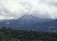 Mount Umunhum is dusted with snow a few times a year.
The summit of Mount Umunhum is the site of the former Almaden Air Force Station, an early-warning radar station that operated from 1958 to 1980. Most of the mountain is within the Sierra Azul Open Space Preserve, managed by the Midpeninsula Regional Open Space District (MROSD).
The summit is closed to the public due to lead, black mold, and asbestos contamination of the former Air Force station. Plans are underway to clean up and restore the summit for public use, with demolition of the landmark tower being considered.[4]
The mountain is also the site of the Bay Area NEXRAD weather radar.[5] The high elevation is necessary for line of sight in the region's varied terrain, but it also limits the ability to detect storms with bases lower in the atmosphere.
Sometimes referred to as "Mount Um" by locals,[6] the mountain is a well-known landmark in the bay area.[6]
References
- ^ a b "Mount Umunhum, California". Peakbagger.com. http://www.peakbagger.com/peak.aspx?pid=23816.
- ^ "Mount Umunhum". Geographic Names Information System, U.S. Geological Survey. http://geonames.usgs.gov/pls/gnispublic/f?p=gnispq:3:::NO::P3_FID:236770.
- ^ "Sierra Azul Open Space Preserve". Midpeninsula Regional Open Space District. http://www.openspace.org/preserves/pr_sierra_azul.asp. Retrieved 2008-04-11.
- ^ "Mt. Umunhum Cleanup and Restoration". Midpeninsula Regional Open Space District. http://www.mtumunhum.org. Retrieved 2010-12-20.
- ^ "NOAA Agencies Partner with the Private Sector". National Oceanic and Atmospheric Administration. http://hmt.noaa.gov/news/2007/pdf/KPIX_partnership.pdf.
- ^ a b Boxer, Barbara (2009-10-20), "Opinion: It's past time for federal government to clean up Mount Um", San Jose Mercury News (San Jose, California), ISSN 0747-2099, OCLC 10553708, http://www.mercurynews.com/opinion/ci_13603341, retrieved 2009-10-23[dead link]
External links
- "Mt. Umunhum Clean Up and Restoration". Midpeninsula Regional Open Space District. http://www.mtumunhum.org.
- "Mount Umunhum". SummitPost.org. http://www.summitpost.org/page/153994.
- David Schwaderer (June 2009). Mt. Umunhum. Los Altos, California: Midpeninsula Regional Open Space District. http://www.youtube.com/watch?v=kieSuWnhiu8. Retrieved 2010-07-12. MROSD documentary on Mount Umunhum; 4m, 29s.
- "Almaden Air Force Station Veterans Association". http://www.AlmadenAFS.org.
Santa Cruz Mountains Peaks Black Mountain · Loma Prieta · Long Ridge · Montara Mountain · Mount Bielawski · Mount Thayer · Mount Umunhum · San Bruno Mountain · Santa Teresa Hills
Rivers and creeks Adobe Creek · Bean Creek · Branciforte Creek · Butano Creek · Carbonera Creek · Guadalupe River · Little Boulder Creek · Loch Lomond · Los Alamitos Creek · Los Gatos Creek · Naples Creek · Permanente Creek · Pescadero Creek · Peters Creek · Pilarcitos Creek · San Bruno Creek · San Francisquito Creek · San Lorenzo River · San Pedro Creek · San Vicente Creek · Stevens Creek · Tip Toe Falls · Uvas Creek · Waddell Creek · Waterman Creek · Zayante CreekParks Hiking trails Other Categories:- Mountains of Santa Clara County, California
- Mountains of the San Francisco Bay Area
- Santa Cruz Mountains


Wikimedia Foundation. 2010.