- North Ockendon
-
Coordinates: 51°34′N 0°19′E / 51.56°N 0.31°E
North Ockendon 
 North Ockendon
North Ockendon shown within Greater LondonOS grid reference TQ595855 - Charing Cross 18 mi (29 km) WSW London borough Havering Ceremonial county Greater London Region London Country England Sovereign state United Kingdom Post town UPMINSTER Postcode district RM14 Dialling code 01708 Police Metropolitan Fire London Ambulance London EU Parliament London UK Parliament Hornchurch and Upminster London Assembly Havering and Redbridge List of places: UK • England • London North Ockendon is an outlying settlement of northeast London, England and part of the London Borough of Havering. It is located 18 miles (29 km) east northeast of Charing Cross and consists of a dispersed settlement within the Metropolitan Green Belt. It was historically an ancient parish in the county of Essex, that was abolished for civil purposes in 1936.[1]
Contents
History
North Ockendon (parish) population 1881 329 1891 351 1901 340 1911 309 1921 326 1931 291 source: UK census[2] North Ockendon parish had an ancient shape that was elongated east-west, thus contrasting with a series of perpendicular parishes to its north and west. With the adjoining parishes this formed a large estate that is at least middle-Saxon or, perhaps, even Roman or Bronze age. From 1894 until it was abolished in 1936, North Ockendon formed a parish in the Orsett Rural District of Essex. The majority of its former area was used to enlarge the Cranham parish of Hornchurch Urban District and the remainder of the former parish, around 383 acres (1.55 km2), was used to form part of Thurrock Urban District in 1936. In 1965 Hornchurch Urban District was abolished and its former area, including North Ockendon, was transferred to Greater London and used to form the present-day London Borough of Havering; thus it became the only part of Greater London outside the M25 motorway.
North Ockendon is the location of Stubbers, a former stately home which was demolished in 1955 and the grounds of which is now used as an activity centre.[3]
Elizabeth Kucinich, wife of the U.S. congressman and presidential candidate, was born in North Ockendon in 1977.
Geography
To the east is a small area of fenland, which extends into Bulphan and the rest is clays and Thames alluvials. The land is entirely 75 feet (23 m) below sea-level[citation needed]. The field boundaries are wholly rectilinear. To the far north, beyond the London, Tilbury and Southend Railway, it borders the villages of Great Warley, Little Warley and Childerditch in the borough of Brentwood, the settlements of West Horndon and Bulphan to the east and South Ockendon to the south which is in the borough and unitary authority of Thurrock. The parish church of St Mary Magdelene has a probably re-used Norman nave door on the south side of the nave.
Transport
The nearest railway stations are at Ockendon and Upminster.
References
- ^ Youngs, Frederic (1979). Guide to the Local Administrative Units of England. I: Southern England. London: Royal Historical Society. ISBN 0901050679.
- ^ Vision of Britain - North Ockendon. Retrieved on 7 February 2010.
- ^ History of Stubbers
External links
London Borough of Havering Districts Ardleigh Green · Chase Cross · Coldharbour · Collier Row · Corbets Tey · Cranham · Elm Park · Emerson Park · Frog Island · Gallows Corner · Gidea Park · Hacton · Harold Hill · Harold Park · Harold Wood · Havering-atte-Bower · Heath Park · Hornchurch · Noak Hill · North Ockendon · Rainham · Rise Park · Romford · Rush Green · South Hornchurch · Upminster · Upminster Bridge · Wennington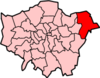
Attractions CEME · The Diver · Havering Museum · Langtons · Queen's Theatre · Rainham Hall · Tithe Barn Museum · Upminster WindmillMajor retail Parks and open spaces Bedfords Park · Dagnam Park · Havering Country Park · Hornchurch Country Park · Pyrgo Park · Tylers Common · Wildspace Conservation Park · Upminster ParkConstituencies Tube and rail stations Other topics Categories:- Districts of London
- Districts of Havering
- Villages in London
- Districts of London listed in the Domesday Book


Wikimedia Foundation. 2010.