- Havering parks and open spaces
-
The London Borough of Havering is a London borough in northeast London, England. Part of Outer London, much of its area is protected from development by the Metropolitan Green Belt and more than half the borough is now parkland. Its parks and open spaces range from the large urban park to village greens and there are more than a hundred of them in total, mostly in the care of Havering London Borough Council, but some by other organisations. Part of the extensive community forest known as Thames Chase is also within the borough and a large new regional parkland is currently under development, called Wildspace. Other parks and open spaces are:
References
External links
- Havering London Borough Council: Parks and Open Spaces A - G
- Havering London Borough Council: Parks and Open Spaces H - Q
- Havering London Borough Council: Parks and Open Spaces R - Z
London Borough of Havering Districts Ardleigh Green · Chase Cross · Coldharbour · Collier Row · Corbets Tey · Cranham · Elm Park · Emerson Park · Frog Island · Gallows Corner · Gidea Park · Hacton · Harold Hill · Harold Park · Harold Wood · Havering-atte-Bower · Heath Park · Hornchurch · Noak Hill · North Ockendon · Rainham · Rise Park · Romford · Rush Green · South Hornchurch · Upminster · Upminster Bridge · Wennington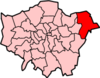
Attractions CEME · The Diver · Havering Museum · Langtons · Queen's Theatre · Rainham Hall · Tithe Barn Museum · Upminster WindmillMajor retail Parks and open spaces Bedfords Park · Dagnam Park · Havering Country Park · Hornchurch Country Park · Pyrgo Park · Tylers Common · Wildspace Conservation Park · Upminster ParkConstituencies Tube and rail stations Other topics Parks and open spaces by London borough Barking and Dagenham · Barnet · Bexley · Brent · Bromley · Camden · Croydon · Ealing · Enfield · Greenwich · Hackney · Hammersmith and Fulham · Haringey · Harrow · Havering · Hillingdon · Hounslow · Islington · Kensington and Chelsea · Kingston · Lambeth · Lewisham · Merton · Newham · Redbridge · Richmond · Southwark · Sutton · Tower Hamlets · Waltham Forest · Wandsworth · Westminster
Categories:- Parks and open spaces in Havering

Wikimedia Foundation. 2010.