- Danson Park
-
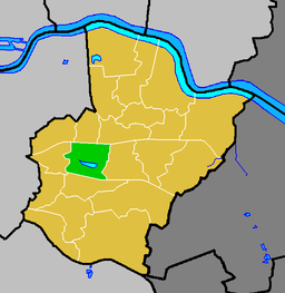
Danson Park is the name of a park located between Welling and Bexleyheath in the London Borough of Bexley, and the name of the electoral ward that covers the park and the surrounding area.
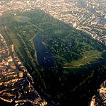
At 78 hectares, it is the largest public park in the London Borough of Bexley and one of the most important in the area. The landscape was designed and laid out by Nathaniel Richmond, assistant to Capability Brown from 1761 to 1763. At its centre is a picturesque 7.8 hectare lake [1]to the south of Danson House. The Danson Stables public house is also located in the park. The Boathouse (function suite and restaurant) is near the lake. [2]
The park is located at grid reference TQ472752. Rochester Way, the A2 road marks the southern boundary of both the park and the ward.
Once a year, for two days the park plays host to the Danson Festival a large scale event which can attract up to 30,000 visitors to the park. The festival includes many stalls such as arts, crafts, charities and others. There is also a fun fair with various rides. The festival usually runs on the first weekend of July each year. The main focal point of the festival is the main stage on which various local artists perform, in addition to some big names. Past festivals have seen the likes of The AllStars with Jocelyn Brown, Alexander O'Neal, X-factor's Rowetta, and Peter Andre and Katie Price. The festival is run by Bexley Council.
The one hectare Danson Park Bog Garden is a Local Nature Reserve.[3]
External links
- Danson Park Photos
- The Friends of Danson Park
- Danson Festival Website
- Danson Park - Bexley London Borough Council
- Danson Park ward at Bexley.gov
- Danson Park ward map at Bexley.gov
- Developments since 1890
- Welling Website
- Restoring one of the miniature railway engines from the railway that ran in the park
References
Coordinates: 51°27′24″N 0°07′02″E / 51.45665°N 0.11729°E
Parks and open spaces by London borough Barking and Dagenham · Barnet · Bexley · Brent · Bromley · Camden · Croydon · Ealing · Enfield · Greenwich · Hackney · Hammersmith and Fulham · Haringey · Harrow · Havering · Hillingdon · Hounslow · Islington · Kensington and Chelsea · Kingston · Lambeth · Lewisham · Merton · Newham · Redbridge · Richmond · Southwark · Sutton · Tower Hamlets · Waltham Forest · Wandsworth · Westminster
Categories:- Parks and open spaces in Bexley
- Local Nature Reserves in England
- Nature reserves in London
Wikimedia Foundation. 2010.


