- Coldharbour, Havering
-
Coordinates: 51°29′29″N 0°11′18″E / 51.4913°N 0.1882°E
Coldharbour 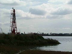
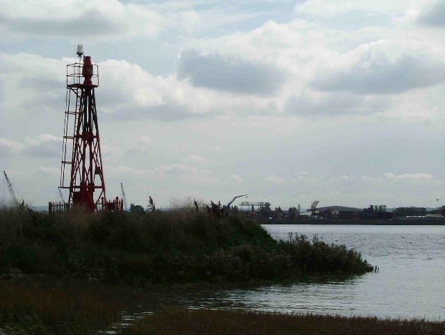
Coldharbour Point on the River Thames
 Coldharbour
Coldharbour shown within Greater LondonOS grid reference TQ525785 London borough Havering Ceremonial county Greater London Region London Country England Sovereign state United Kingdom Post town RAINHAM Postcode district RM13 Dialling code 01708 Police Metropolitan Fire London Ambulance London EU Parliament London UK Parliament Dagenham and Rainham London Assembly Havering and Redbridge List of places: UK • England • London Coldharbour is a district of the London Borough of Havering, adjacent to the River Thames, in London, England.
It is the location of Coldharbour Point, where there has been a lighthouse since 1885. It is on the route of the London Outer Orbital Path.
A ferry operated from Coldharbour Point to Erith on the southern bank of the Thames from the Middle Ages until the end of the 19th century.
London Borough of Havering Districts Ardleigh Green · Chase Cross · Coldharbour · Collier Row · Corbets Tey · Cranham · Elm Park · Emerson Park · Frog Island · Gallows Corner · Gidea Park · Hacton · Harold Hill · Harold Park · Harold Wood · Havering-atte-Bower · Heath Park · Hornchurch · Noak Hill · North Ockendon · Rainham · Rise Park · Romford · Rush Green · South Hornchurch · Upminster · Upminster Bridge · Wennington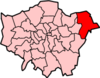
Attractions CEME · The Diver · Havering Museum · Langtons · Queen's Theatre · Rainham Hall · Tithe Barn Museum · Upminster WindmillMajor retail Parks and open spaces Bedfords Park · Dagnam Park · Havering Country Park · Hornchurch Country Park · Pyrgo Park · Tylers Common · Wildspace Conservation Park · Upminster ParkConstituencies Tube and rail stations Other topics Categories:- Districts of Havering
- Districts of London
- Districts of London on the River Thames
- Port of London
- London geography stubs


Wikimedia Foundation. 2010.