- County of Bogong
-
Bogong
Victoria
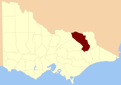
Location in VictoriaLands administrative divisions around Bogong Denison (NSW) Hume (NSW) Benambra Delatite Bogong Benambra Wonnangatta Dargo Dargo The County of Bogong is one of the 37 counties of Victoria which are part of the cadastral divisions of Australia, used for land titles. It is located south of the Murray River, east of the Ovens River, and west of the Mitta Mitta River. Mount Bogong is located there, the highest mountain in Victoria.
Contents
Origin of the name
Bogong moth is a native insect of Australia. This was once considered a delicacy by the aborigines who collected the dormant larvae and cooked them. A town, Bogong, in the state of Victoria has been named after the moth.[1]
Parishes
Parishes within the county:
- Barambogie, Victoria
- Baranduda, Victoria
- Barnawartha North, Victoria
- Barnawartha South, Victoria
- Barwidgee, Victoria
- Beechworth, Victoria
- Beethang, Victoria
- Belvoir West, Victoria
- Bingo-Munjie, Victoria
- Bingo-Munjie North, Victoria
- Bingo-Munjie South, Victoria
- Bogong North, Victoria
- Bogong South, Victoria
- Bolga, Victoria
- Bonegilla, Victoria
- Bontherambo, Victoria
- Boorgunyah, Victoria
- Boorhaman, Victoria
- Bright, Victoria
- Brimin, Victoria
- Bruarong, Victoria
- Bundara-Munjie, Victoria
- Byawatha, Victoria
- Carlyle, Victoria
- Carraragarmungee, Victoria
- Carruno, Victoria
- Chiltern, Victoria
- Chiltern West, Victoria
- Darbalang, Victoria
- Dederang, Victoria
- Dorchap, Victoria
- El Dorado, Victoria
- Estcourt, Victoria
- Everton, Victoria
- Freeburgh, Victoria
- Gooramadda, Victoria
- Gundowring, Victoria
- Harrietville, Victoria
- Hotham, Victoria
- Kergunyah, Victoria
- Kergunyah North, Victoria
- Lilliput, Victoria
- Lochiel, Victoria
- Ludrik-Munjie, Victoria
- Magorra, Victoria
- Mudgeegonga, Victoria
- Mullagong, Victoria
- Mullindolingong, Victoria
- Murmungee, Victoria
- Murramurrangbong, Victoria
- Myrtleford, Victoria
- Noorongong, Victoria
- Norong, Victoria
- Nowyeo, Victoria
- Omeo, Victoria
- Porepunkah, Victoria
- Stanley, Victoria
- Tallandoon, Victoria
- Tangambalanga, Victoria
- Tarrawingee, Victoria
- Tawanga, Victoria
- Theddora, Victoria
- Tongaro, Victoria
- Undowah, Victoria
- Wallaby, Victoria
- Wangaratta North, Victoria
- Wermatong, Victoria
- Wodonga, Victoria
- Wollonaby, Victoria
- Woorragee, Victoria
- Woorragee North, Victoria
- Yackandandah, Victoria
References
- ^ Physical Map of Australia, special advertising feature of Australia.com on pg 16, National Geographic magazine, May 2006, Washington DC
See also
Coordinates: 36°15′S 146°50′E / 36.25°S 146.833°E
Counties of Victoria Anglesey • Benambra • Bendigo • Bogong • Borung • Bourke • Buln Buln • Croajingolong • Dalhousie • Dargo • Delatite • Dundas • Evelyn • Follett • Gladstone • Grant • Grenville • Gunbower • Hampden • Heytesbury • Kara Kara • Karkarooc • Lowan • Millewa • Moira • Mornington • Normanby • Polwarth • Ripon • Rodney • Talbot • Tambo • Tanjil • Tatchera • Villiers • Weeah • Wonnangatta
Categories:- Counties of Victoria (Australia)
- Victoria (Australia) geography stubs
Wikimedia Foundation. 2010.