- County of Follett
-
Follett
Victoria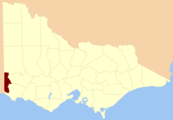
Location in VictoriaLands administrative divisions around Follett South Australia Lowan Dundas South Australia Follett Normanby South Australia Normanby Normanby The County of Follett is one of the 37 counties of Victoria which are part of the cadastral divisions of Australia, used for land titles. It comprises a strip in the far southwest of the state bounded by the Glenelg River to the east, South Australia to the west and Elderslie Creek to the north beyond Casterton. No larger towns are contained within its boundaries. It was proclaimed in 1849.
Parishes
Parishes within the county:
- Ardno
- Bahgallah
- Bogalara
- Byjuke
- Dartmoor
- Drajurk
- Kaladbro
- Kanawinka
- Kinkella
- Langkoop
- Mageppa
- Malanganee
- Mumbannar
- Nagwarry
- Nangeela
- Palpara
- Roseneath
- Tooloy
- Tullich
- Wanwin
- Werrikoo
- Wilkin
- [1]
References
- ^ Rootsweb Genealogy, Victorian Counties, http://freepages.genealogy.rootsweb.ancestry.com/~kenmac/victowns/viccounties.htm, retrieved 2008-09-20
Coordinates: 37°30′S 141°15′E / 37.5°S 141.25°E
Counties of Victoria Anglesey • Benambra • Bendigo • Bogong • Borung • Bourke • Buln Buln • Croajingolong • Dalhousie • Dargo • Delatite • Dundas • Evelyn • Follett • Gladstone • Grant • Grenville • Gunbower • Hampden • Heytesbury • Kara Kara • Karkarooc • Lowan • Millewa • Moira • Mornington • Normanby • Polwarth • Ripon • Rodney • Talbot • Tambo • Tanjil • Tatchera • Villiers • Weeah • Wonnangatta
Categories:- Counties of Victoria (Australia)
- Victoria (Australia) geography stubs

Wikimedia Foundation. 2010.