- County of Normanby
-
Normanby
Victoria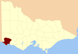
Location in VictoriaLands administrative divisions around Normanby Follett Dundas Villiers Follett Normanby Villiers Bass Strait Bass Strait Bass Strait The County of Normanby is one of the 37 counties of Victoria which are part of the cadastral divisions of Australia, used for land titles. The County is in the Western District of Victoria bounded by the Glenelg River in the west and the Eumeralla River in the east, by a line through Casterton and Hamilton in the north, and by Bass Strait (Portland Bay) to the south. Larger towns include Hamilton, Portland and Heywood. The County was proclaimed in 1853.
Parishes
Parishes within the county:
- Annya
- Ardonachie
- Audley
- Balrook
- Bessiebelle
- Bolwarra
- Bramburra
- Branxholme
- Byaduk
- Byambynee
- Cobboboonee
- Condah
- Croxton West
- Curracurt
- Dartmoor (part in the County of Follett)
- Digby
- Drik Drik
- Drumborg
- Dunmore
- Eumeralla
- Glenaulin
- Glenelg (part in the County of Follett)
- Gorae
- Grassdale
- Greenhills
- Heywood
- Homerton
- Hotspur
- Kentbruck
- Killara
- Macarthur
- Merino
- Mocamboro
- Monivae
- Mouzie
- Murndal
- Myamyn
- Myaring
- Napier
- Narrawong
- Portland
- Sandford
- South Hamilton
- Tahara
- Tarragal
- Trewalla
- Tyrendarra
- Warrabkook
- Warrain
- Wataepoolan
- Weecurra
- Weerangourt
- Winyayung
- Yatchew West
- Yulecart
- [1]
References
- ^ Rootsweb Genealogy, Victorian Counties, http://freepages.genealogy.rootsweb.ancestry.com/~kenmac/victowns/viccounties.htm, retrieved 2008-09-20
- Research aids, Victoria 1910
- Map of the counties of Follett, Dundas, Ripon, Normanby, Villiers, Hampden, Heytesbury / John Sands
Coordinates: 37°59′S 141°40′E / 37.983°S 141.667°E
Counties of Victoria Anglesey • Benambra • Bendigo • Bogong • Borung • Bourke • Buln Buln • Croajingolong • Dalhousie • Dargo • Delatite • Dundas • Evelyn • Follett • Gladstone • Grant • Grenville • Gunbower • Hampden • Heytesbury • Kara Kara • Karkarooc • Lowan • Millewa • Moira • Mornington • Normanby • Polwarth • Ripon • Rodney • Talbot • Tambo • Tanjil • Tatchera • Villiers • Weeah • Wonnangatta
Categories:- Counties of Victoria (Australia)
- Victoria (Australia) geography stubs

Wikimedia Foundation. 2010.