- County of Bendigo
-
Bendigo
Victoria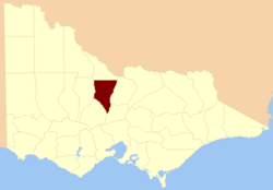
Location in VictoriaLands administrative divisions around Bendigo Tatchera Gunbower Rodney Gladstone Bendigo Rodney Gladstone Talbot Dalhousie The County of Bendigo is one of the 37 counties of Victoria which are part of the cadastral divisions of Australia, used for land titles. It includes the city of Bendigo. It is bounded by the Campaspe River in the east, and the Loddon River in the west.
Parishes
Parishes within the county:
- Axedale, Victoria (also in Rodney)
- Bagshot, Victoria
- Ballendella, Victoria
- Bamawm, Victoria
- Bridgewater, Victoria
- Calivil, Victoria
- Derby, Victoria
- Diggorra, Victoria
- Dingee, Victoria
- Egerton, Victoria
- Ellesmere, Victoria
- Elmore, Victoria
- Eppalock, Victoria
- Goornong, Victoria
- Hayanmi, Victoria
- Huntly, Victoria
- Janiember East, Victoria
- Janiember West, Victoria
- Jarklan, Victoria
- Kamarooka, Victoria
- Kimbolton, Victoria
- Knowsley, Victoria
- Knowsley East, Victoria
- Laanecoorie, Victoria
- Leichardt, Victoria
- Lockwood, Victoria
- Lyell, Victoria
- Mandurang, Victoria
- Marong, Victoria
- Milloo, Victoria
- Minto, Victoria
- Mitiamo, Victoria
- Neilborough, Victoria
- Nerring, Victoria
- Nolan, Victoria
- Pannoobamawm, Victoria
- Pannoomilloo, Victoria
- Pompapeil, Victoria
- Ravenswood, Victoria (also in Talbot)
- Rochester West, Victoria
- Salisbury, Victoria
- Sandhurst, Victoria
- Sedgwick, Victoria
- Shelbourne, Victoria
- Strathfieldsaye, Victoria
- Talambe, Victoria
- Tandarra, Victoria
- Wanurp, Victoria
- Warragamba, Victoria
- Wellsford, Victoria
- Whirrakee, Victoria
- Woodstock, Victoria
- Yallook, Victoria
- Yarraberb, Victoria
- Yarryne, Victoria
References
- Vicnames, place name details
- Research aids, Victoria 1910
- Map of the county of Bendigo showing colony and parish boundaries, main roads, telegraph lines and railways. 1886, J. Sands.
Counties of Victoria Anglesey • Benambra • Bendigo • Bogong • Borung • Bourke • Buln Buln • Croajingolong • Dalhousie • Dargo • Delatite • Dundas • Evelyn • Follett • Gladstone • Grant • Grenville • Gunbower • Hampden • Heytesbury • Kara Kara • Karkarooc • Lowan • Millewa • Moira • Mornington • Normanby • Polwarth • Ripon • Rodney • Talbot • Tambo • Tanjil • Tatchera • Villiers • Weeah • Wonnangatta
Categories:- Counties of Victoria (Australia)
- Victoria (Australia) geography stubs

Wikimedia Foundation. 2010.