- Counties of Victoria
-
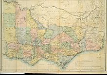 1877 map of the counties of Victoria
The Australian state of Victoria is divided into 37 counties. They are part of the lands administrative divisions of Australia. These counties were gazetted in stages between 1849 and 1871 as Victoria was progressively opened up to European settlement. By 1890 all parish boundaries had been gazetted. Unlike counties in the United States and the United Kingdom, Victoria's counties have no administrative or political function. They exist purely as cadastral units: used for the purposes of identifying the location of any piece of land. The counties are furthermore divided into 2914 parishes and townships.
The county names have also been traditionally used as names for electoral districts, although these districts seldom have boundaries coinciding exactly with county boundaries. The Victorian Legislative Assembly currently has electoral districts called Benambra, Evelyn, Lowan, Mornington, Polwarth, Ripon and Rodney. The counties are also related to the boundaries for the Victorian forecast districts.[1]
Contents
Naming of the Counties
 1852 map of eastern Victoria, showing seven former counties
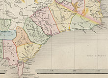
The majority of the counties proclaimed prior to 1871 were named after conservative and titled English politicians. The counties formed from the Gipps Land District, Loddon Land District, Murray Land District and Wimmera Land District proclaimed in 1871 were all given aboriginal names.
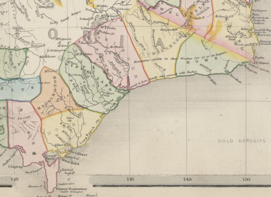
Earlier maps of Gippsland area in the eastern part of the state show unsurveyed counties of Douro (a title of the Duke of Wellington), Bass, Haddington, Bruce, Abinger, Combermere and Howe with approximate boundaries. These counties are shown on several early maps such as 1845 map[2] and 1848 map.[3] They were presumably changed in the mid 1860s, as they appear on maps up until 1864,[4] but the new counties appear on an 1865 map.[5] This was during the period of the liberal Government (1863-1868) of Premier James McCulloch.
Land Districts
Victoria was also divided into land districts in the nineteenth century, as shown on a 1864 map.[6] The land districts were used as the names for parts of the state where no counties had been proclaimed yet. The land districts included:
- Bourke Land District (Melbourne area, including the County of Bourke)
- Geelong (or Grant) Land District
- Gipps Land District (name for the area today is still Gippsland)
- Loddon Land District
- Murray Land District
- Normanby Land District [7]
- Western Land District
- Wimmera Land District (the southern part still called the Wimmera today)
List of Victorian Counties with the year proclaimed
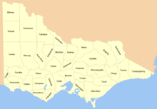 Map showing the names of the counties
- 1849 County of Anglesey
- 1871 County of Benambra
- 1869 County of Bendigo
- 1871 County of Bogong
- 1871 County of Borung
- 1853 County of Bourke
- 1871 County of Buln Buln
- 1871 County of Croajingolong
- 1849 County of Dalhousie
- 1871 County of Dargo
- 1871 County of Delatite
- 1849 County of Dundas
- 1849 County of Evelyn
- 1849 County of Follett
- 1870 County of Gladstone
- 1853 County of Grant
- 1849 County of Grenville
- 1871 County of Gunbower
- 1849 County of Hampden
- 1849 County of Heytesbury
- 1871 County of Kara Kara
- 1871 County of Karkarooc
- 1871 County of Lowan
- 1871 County of Millewa
- 1871 County of Moira
- 1849 County of Mornington
- 1853 County of Normanby
- 1849 County of Polwarth
- 1849 County of Ripon
- 1871 County of Rodney
- 1849 County of Talbot
- 1871 County of Tambo
- 1871 County of Tanjil
- 1871 County of Tatchera
- 1849 County of Villiers
- 1871 County of Weeah
- 1871 County of Wonnangatta
See also
- List of localities (Victoria)
- Local Government Areas of Victoria
- List of places in Victoria (Australia) named from pastoral runs
- Regions of Victoria
References
- ^ "Victorian Forecast Areas Map". Bureau of Meteorology. Commonwealth of Australia. http://www.bom.gov.au/weather/vic/vic-forecast-map.shtml.
- ^ Rapkin, John (1845). "Australia". National Library of Australia. London. http://nla.gov.au/nla.map-rm3709.
- ^ "(No 2.) outline map shewing the positions of the proposed New Counties in the Port Phillip district which will be ready for Proclamation before the end of the Year 1848". National Library of Australia. London: J. Arrowsmith. 1948. http://nla.gov.au/nla.map-nk2456-130.
- ^ Bartholomew, John (1864). "Victoria". National Library of Australia. London; Liverpool: George Philip & Son. http://nla.gov.au/nla.map-nk10524.
- ^ Victoria. Dept. of Crown Lands and Survey (1865). "Map of Victoria". National Library of Australia. Melbourne: Dept. of Lands & Survey. http://nla.gov.au/nla.map-t1466.
- ^ Stephens, W. B. (1864). "Stephens' new map of Victoria". National Library of Australia. Melbourne: W. B. Stephens. http://nla.gov.au/nla.map-f280.
- ^ Skene, Alexander James (1945). "Map of the district of Geelong". Geelong, Victoria: Jas. Harrison, Advertiser Office. http://nla.gov.au/nla.map-rm983.
- ^ "List of the Counties in the State of Victoria - 1910". Rootsweb Genealogy. Ancestry.com. 2000. http://freepages.genealogy.rootsweb.ancestry.com/~kenmac/victowns/viccounties.htm. Retrieved 2008-09-20.
Lands administrative divisions of Australia Counties of Victoria Anglesey • Benambra • Bendigo • Bogong • Borung • Bourke • Buln Buln • Croajingolong • Dalhousie • Dargo • Delatite • Dundas • Evelyn • Follett • Gladstone • Grant • Grenville • Gunbower • Hampden • Heytesbury • Kara Kara • Karkarooc • Lowan • Millewa • Moira • Mornington • Normanby • Polwarth • Ripon • Rodney • Talbot • Tambo • Tanjil • Tatchera • Villiers • Weeah • Wonnangatta
Categories:- Lists of country subdivisions
- Counties of Victoria (Australia)
- Victoria (Australia)-related lists
- Lists of places in Australia
- Counties of Australia


Wikimedia Foundation. 2010.