- County of Grenville, Victoria
-
Grenville
Victoria
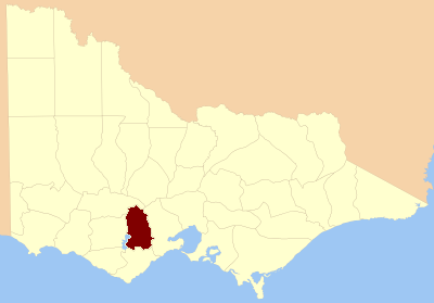
Location in VictoriaLands administrative divisions around Grenville Ripon Ripon Grant Hampden Grenville Grant Heytesbury Polwarth Grant The County of Grenville is one of the 37 counties of Victoria which are part of the cadastral divisions of Australia, used for land titles. It is located to the north-east of Lake Corangamite and includes Cressy. Ballarat is on its north-eastern edge. The boundary to the east is the Yarrowee River, and to the south part of the Barwon River. Colac is on its southern edge.
Parishes
Parishes within the county:
- Argyle, Victoria
- Ballaarat, Victoria
- Bungaree, Victoria
- Cardigan, Victoria
- Carngham, Victoria
- Clarkesdale, Victoria
- Commeralghip, Victoria
- Corindhap, Victoria
- Cressy, Victoria
- Cundare, Victoria
- Dereel, Victoria
- Doroq, Victoria
- Dreeite, Victoria
- Enfield, Victoria
- Gellibrand, Victoria
- Haddon, Victoria
- Hesse, Victoria
- Karngun, Victoria
- Kurac-a-ruc, Victoria
- Lawaluk, Victoria
- Lynchfield, Victoria
- Mannibadar, Victoria
- Mindai, Victoria
- Mirnee, Victoria
- Mortchup, Victoria
- Murdeduke, Victoria
- Naringhil North, Victoria
- Naringhil South, Victoria
- Ondit, Victoria
- Poliah North, Victoria
- Poliah South, Victoria
- Poorneet, Victoria
- Scarsdale, Victoria
- Shelford, Victoria
- Shelford West, Victoria
- Smythesdale, Victoria
- Turkeeth, Victoria
- Wallinduc, Victoria
- Warracbarunah, Victoria
- Warrambine, Victoria
- Warrion, Victoria
- Weering, Victoria
- Wilgul North, Victoria
- Wilgul South, Victoria
- Windermere, Victoria
- Wingeel, Victoria
- Wurrook, Victoria
- Yarima, Victoria
- Yarrowee, Victoria
References
Coordinates: 37°40′S 143°40′E / 37.667°S 143.667°E
Counties of Victoria Anglesey • Benambra • Bendigo • Bogong • Borung • Bourke • Buln Buln • Croajingolong • Dalhousie • Dargo • Delatite • Dundas • Evelyn • Follett • Gladstone • Grant • Grenville • Gunbower • Hampden • Heytesbury • Kara Kara • Karkarooc • Lowan • Millewa • Moira • Mornington • Normanby • Polwarth • Ripon • Rodney • Talbot • Tambo • Tanjil • Tatchera • Villiers • Weeah • Wonnangatta
Categories:- Counties of Victoria (Australia)
- Victoria (Australia) geography stubs
Wikimedia Foundation. 2010.