- Dereel, Victoria
-
Dereel
Victoria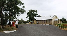
Dereel Soldiers' Memorial Hall and CFA shed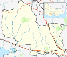
 Dereel
Population: 669[1] Postcode: 3352 Elevation: 348 m (1,142 ft) [2] Location: LGA: Golden Plains Shire State District: Polwarth Federal Division: Corangamite Dereel is a town in the Western District of the Australian state of Victoria. At the 2006 census, Dereel and the surrounding area had a population of 669.[1]
It is located on the Ballarat-Colac Road, 33 kilometres (21 mi) from Ballarat and 70 kilometres (43 mi) from Colac. There is no clearly defined town centre, though the Dereel Soldiers' Memorial Hall, located on Swamp Road, is commonly considered as the town centre.
Dereel Post Office opened on 1 November 1868 and closed in 1971. [3]
Dereel includes a large wetlands area, referred to as the "Swamp" or "Lagoon". In the current (2007) drought it is almost dry.
References
- ^ a b Australian Bureau of Statistics (25 October 2007). "Dereel (State Suburb)". 2006 Census QuickStats. http://www.censusdata.abs.gov.au/ABSNavigation/prenav/LocationSearch?collection=Census&period=2006&areacode=SSC25467&producttype=QuickStats&breadcrumb=PL&action=401. Retrieved 2007-11-18.
- ^ http://nona.net/features/map/placedetail.1505025/Dereel/ Retrieved on 24 July 2009
- ^ Premier Postal History, Post Office List, https://www.premierpostal.com/cgi-bin/wsProd.sh/Viewpocdwrapper.p?SortBy=VIC&country=, retrieved 2008-04-11
Towns in the Golden Plains Shire Local Government Area Bannockburn · Berringa · Cape Clear · Corindhap · Dereel · Durdidwarrah · Enfield · Gheringhap · Haddon · Happy Valley · Inverleigh · Lethbridge · Linton · Maude · Meredith · Napoleons · Newtown · Rokewood · Scarsdale · Shelford · Sheoaks · Smythesdale · Springdallah · Steiglitz · Sutherlands Creek · Teesdale
Coordinates: 37°49′11″S 143°45′05″E / 37.819722°S 143.751447°E
Categories:- Towns in Victoria (Australia)
- Victoria (Australia) geography stubs


Wikimedia Foundation. 2010.