- County of Villiers
-
Villiers
Victoria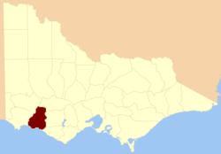
Location in VictoriaLands administrative divisions around Villiers Dundas Ripon Ripon Normanby Villiers Hampden Southern Ocean Southern Ocean Heytesbury The County of Villiers is one of the 37 counties of Victoria which are part of the cadastral divisions of Australia, used for land titles. It includes the area to the north of Warrnambool, and to the west of the Hopkins River.
Parishes
Parishes include:
- Adzar, Victoria
- Ballangeich, Victoria
- Banangal, Victoria
- Belfast, Victoria
- Bilpah, Victoria
- Boonahwah, Victoria
- Boorpool, Victoria
- Bootahpool, Victoria
- Boramboram, Victoria
- Broadwater, Victoria
- Buckeran Yarrack, Victoria
- Bullanbul, Victoria
- Caramut, Victoria
- Caramut South, Victoria
- Chatsworth West, Victoria
- Clonleigh, Victoria
- Codrington, Victoria
- Cooramook, Victoria
- Corea, Victoria
- Croxton East, Victoria
- Dunkeld, Victoria
- Framlingham West, Victoria
- Hexham West, Victoria
- Jennawarra, Victoria
- Kangertong, Victoria
- Kapong, Victoria
- Kay, Victoria
- Koroit, Victoria
- Langulac, Victoria
- Linlithgow, Victoria
- Meerai, Victoria
- Minhamite, Victoria
- Minjah, Victoria
- Minjah North, Victoria
- Nanapundah, Victoria
- Nareeb Nareeb, Victoria
- Pom Pom, Victoria
- Purdeet, Victoria
- Purdeet East, Victoria
- Purnim, Victoria
- Quamby, Victoria
- Quamby North, Victoria
- St.Helens, Victoria
- Tallangoork, Victoria
- Wangoom, Victoria
- Warrong, Victoria
- Willatook, Victoria
- Woolsthorpe, Victoria
- Yalimba, Victoria
- Yalimba East, Victoria
- Yambuk, Victoria
- Yangery, Victoria
- Yarpturk, Victoria
- Yatchew East, Victoria
- Yatmerone, Victoria
- Yeth-youang, Victoria
- Yuppeckiar, Victoria
References
- Research Aids, Victoria 1910
- Map of the County of Villiers, 1886, National Library of Australia
- Vicnames, Villiers county
Coordinates: 37°59′S 142°20′E / 37.983°S 142.333°E
Counties of Victoria Anglesey • Benambra • Bendigo • Bogong • Borung • Bourke • Buln Buln • Croajingolong • Dalhousie • Dargo • Delatite • Dundas • Evelyn • Follett • Gladstone • Grant • Grenville • Gunbower • Hampden • Heytesbury • Kara Kara • Karkarooc • Lowan • Millewa • Moira • Mornington • Normanby • Polwarth • Ripon • Rodney • Talbot • Tambo • Tanjil • Tatchera • Villiers • Weeah • Wonnangatta
Categories:- Counties of Victoria (Australia)
- Victoria (Australia) geography stubs

Wikimedia Foundation. 2010.