- County of Karkarooc
-
Karkarooc
Victoria
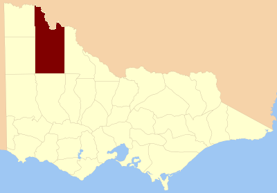
Location in VictoriaEstablished: 24 February 1871 Area: 15,372 km² Lands administrative divisions around Karkarooc Millewa Wentworth (NSW) Taila (NSW) Weeah Karkarooc Tatchera Lowan Borung Kara Kara The County of Karkarooc is one of the 37 counties of Victoria which are part of the cadastral divisions of Australia, used for land titles. It is located to the south of the Murray River, with its western boundary at 142°E, and its eastern boundary at 143°E. Its southern boundary is on the 36°S parallel. Lake Tyrrell is located near the eastern boundary. Mildura is located near the north-western edge.
Parishes
Parishes include:
- Annuello, Victoria
- Ballapur, Victoria
- Baring, Victoria
- Beulah, Victoria
- Bimbourie, Victoria
- Bitchigal, Victoria
- Bitterang, Victoria
- Boigbeat, Victoria
- Boolungal, Victoria
- Boorong, Victoria
- Boorongie, Victoria
- Boulka, Victoria
- Bourka, Victoria
- Brockie, Victoria
- Bumbang, Victoria
- Burnell, Victoria
- Burupga, Victoria
- Byanga, Victoria
- Cambacanya, Victoria
- Cantala, Victoria
- Carool, Victoria
- Carori, Victoria
- Carwarp, Victoria
- Chiprick, Victoria
- Cocamba, Victoria
- Colignan, Victoria
- Cronomby, Victoria
- Curyo, Victoria
- Dattuck, Victoria
- Daytrap, Victoria
- Dennying, Victoria
- Dering, Victoria
- Dewry, Victoria
- Eureka, Victoria
- Gaalanungah, Victoria
- Galaquil, Victoria
- Gama, Victoria
- Gayfield, Victoria
- Geera, Victoria
- Gingimrick, Victoria
- Gorya, Victoria
- Goyura, Victoria
- Gutchu, Victoria
- Jil Jil, Victoria
- Kallery, Victoria
- Karyrie, Victoria
- Kenmare, Victoria
- Kia, Victoria
- Kinabulla, Victoria
- Koimbo, Victoria
- Konardin, Victoria
- Kooroop, Victoria
- Kulkyne, Victoria
- Kulwin, Victoria
- Kurdgweechee, Victoria
- Larundel, Victoria
- Lascelles, Victoria
- Lianiduck, Victoria
- Liparoo, Victoria
- Lyngaller, Victoria
- Manangatang, Victoria
- Margooya, Victoria
- Marlbed, Victoria
- Merbein, Victoria
- Mildura, Victoria
- Minapre, Victoria
- Mittyack, Victoria
- Mittyan, Victoria
- Moah, Victoria
- Moortworra, Victoria
- Mournpoul, Victoria
- Myall, Victoria
- Nandemarriman, Victoria
- Natya, Victoria
- Nenandie, Victoria
- Nowingi, Victoria
- Nulkwyne, Victoria
- Nurnurnemal, Victoria
- Nyallo, Victoria
- Nypo, Victoria
- Ouyen, Victoria
- Paignie, Victoria
- Panitya, Victoria
- Patchewollock, Victoria
- Pier-Millan, Victoria
- Piro, Victoria
- Pullut, Victoria
- Raak, Victoria
- Thanni, Victoria
- Tiega, Victoria
- Timberoo, Victoria
- Toltol, Victoria
- Towma, Victoria
- Trinnta, Victoria
- Tungie, Victoria
- Tyenna, Victoria
- Tyrrell, Victoria
- Wagant, Victoria
- Walle, Victoria
- Walpamunda, Victoria
- Walpeup, Victoria
- Wangry, Victoria
- Watchupga, Victoria
- Wathe, Victoria
- Wemen, Victoria
- Whirily, Victoria
- Wiall, Victoria
- Wilhelmina, Victoria
- Willangie, Victoria
- Winnambool, Victoria
- Wirmbirchip, Victoria
- Wirmbool, Victoria
- Wirrbibial, Victoria
- Woornack, Victoria
- Wortongie, Victoria
- Wymlet, Victoria
- Wyperfeld, Victoria
- Yaapeet, Victoria
- Yallum, Victoria
- Yarrum, Victoria
- Yelwell, Victoria
References
- Vicnames, place name details
- Research aids, Victoria 1910
- Map of the counties of Millewa, Karkarooc, Tatchera and Weeah showing colony and parish boundaries, main roads, telegraph lines and railways. 1886. National Library of Australia
Counties of Victoria Anglesey • Benambra • Bendigo • Bogong • Borung • Bourke • Buln Buln • Croajingolong • Dalhousie • Dargo • Delatite • Dundas • Evelyn • Follett • Gladstone • Grant • Grenville • Gunbower • Hampden • Heytesbury • Kara Kara • Karkarooc • Lowan • Millewa • Moira • Mornington • Normanby • Polwarth • Ripon • Rodney • Talbot • Tambo • Tanjil • Tatchera • Villiers • Weeah • Wonnangatta
Categories:- Counties of Victoria (Australia)
Wikimedia Foundation. 2010.