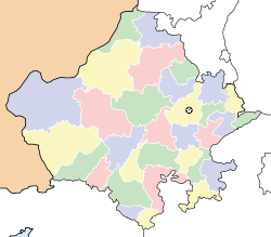
- Degana
-
Degana Junction — town — Coordinates 26°53′42″N 74°19′20″E / 26.895052°N 74.322166°ECoordinates: 26°53′42″N 74°19′20″E / 26.895052°N 74.322166°E Country India State Rajasthan District(s) Nagaur Nearest city Ajmer Parliamentary constituency Nagaur Population 20,000 (2001[update]) Sex ratio 878/1000 ♂/♀ Literacy 65% Time zone IST (UTC+05:30) Area
• 353 metres (1,158 ft)
Degana (Hindi: डेगाना) is a town and surrounding tehsil located in the Nagaur district of Rajasthan, India. The town is situated roughly southeast of 90 km from Nagaur, at a junction of State Highways 59 and 60. Jat, Rajput, Maheshwari and Meghwal founded the village about 150 years back.[citation needed]
A Railway Junction was made in the pre-independence era on the Jaipur-Jodhpur railway track solely for the reason of having a Railway-Node for better operational control as there was a stretch of more than 30 km without any station in-between. With the passage of time, a town came into being by drawing more and more habitation in the last 50 years around the Railway Station owing to the better connectivity to more significant city centers like Jaipur, Jodhpur and Bikaner. The town now has headquarters for administrative units of the tehsil.
Contents
Demography
Degana Gram Panchayat has a population of about 24000 and excludes other village population. There are 13000 voters in Degana. The main occupations of people are agriculture and animal based. Village area is 17000 Acres out of which 2,000 acres (8.1 km2) land is irrigated. Some villagers are employed in eight masonry stone mines around the village. Some people of the village are also associated with Marble industry in Makrana and Kishangarh. Village is fully developed with all modern facilities. Approximately 500 people are working abroad.
Religious sites
Village has the temples of Shitala Mata, Chaumunda mata, Charbhuja, Deonarayan, Vanankatesh, Shiv Mandir, Gaytari Mandir, Veer Teja ji Mandir, Dharmshala hanuman mandir etc. There is an annual cattle-fair in village from Rajathani month Asoja Krishna 1 to 10 Dashahara. Village also has got three Mosques, One Eidgaah for Muslims. Also Muslim Dargaah (Kasnau Baba - Ilahibaksh baba).
Geography
Degana is located at 26°53′42″N 74°19′20″E / 26.895052°N 74.322166°E. It has an average elevation of 353 metres (1161 ft).
Education
There is a Govt. Senior Secondary School with Science, Commerce and Arts faculties situated at Degana-Chandaroon Road. School was developed by Shri Bhanwar Lal Karwa, Chandarun and Hon'ble Citizens of Degana Junction and Chandaroon Village. Degana town has Girls school up to Senior classes and Girls school attached with Maharshi Dayanand Saraswati University for ARTS Subject situated at Sadar Bazar, Deagna Junction. Now town has an English medium school name as Rana International School. The most of one is Sharda Bal Niketan. Also there two degree colleges in Degana Marwar college and Sharada Mahavidyala offering science and Arts course.
Transport
As described above, Degana is a town populated around a railway junction 165 km west of Jaipur on Jaipur-Jodhpur Broad-gauge railway line of North-Westorn Railway. It has a good connectivity with Jaipur (165 km), Jodhpur(149 km), Delhi (473 km) and Bikaner (218 km) through the railway network. Its location is Latitude 26° 53' 45" N and Longitude 74° 19' 15" E.
An old meter-gauge segment initiating from Degana Junction now has been converted to Broad-gauge and has elevated the importance of this Station. This segment runs through Deedwana and joins the Bikaner-Delhi line at Ratangarh. Direct trains are available on a daily basis to Jaipur, Jodhpur, Bikaner, Kota, Delhi, Lucknow, Kanpur, Varanasi, Puri and Kolkata.
Degana is also connected to nearby cities through the two State Highways and many MDR (Major District Roads) but sadly with almost negligible presence of State Transport services on this network. The town falls on midway on the State Highway from Ajmer to Nagaur SH-60 and another State Highway Ajmer to Deedwana SH-59. Private bus services links it to Ajmer, Nagaur,Deedwana, Merta and Makrana (via-Mithariya) but with unpleasant service and oligopolistic system of private bus operators running on approx hourly basis.
Politics and governance
The Degana Assembly Constituency is representsted in Rajasthan Vidhan Sabha by Sh. Ajay Singh Kilak of Bharatiya Janata Party who defeated Sh. Richh Pal Singh Mirdha sitting MLA and stalwart of Indian National Congress by a narrow margin in 2008 Assembly elections. Degana assembly consituency presently forms part of newly created Parliamentary Constituency Rajsamand representated by Sh. Gopal Singh of Indian National Congress.
The town has Sub-Division Headquarter with SDM, Tehsil headquarter with 237+ revenue villages and Judicial Headquarter with ADJ court.
Degana Panchayat Samiti is chaired by Pradhan sh Rampal Mahiya of Indian National Congress. There are 47 Gram Panchayats each with a Sarpanch, several Ward-Panch and a Gram Sevak as official secretary. There is one famous 'Degana Krishi Upaj Mandi 'in degana .The 'Krishi Mandi samiti is chaired by Sh SITARAM NIMBARI CHANDAWATA of [bhartiya janta party]. Krishi mandi samiti works under agriculture ministry Govt of Rajasthan .It work for farmer welfare and agriculture development in the constituency .
External links
References
Nagaur Basni Belima · Didwana · Goredi Chancha · Kuchaman City · Kuchera · Ladnun · Makrana · Merta City · Mundwa · Nagaur · Nawa · Parbatsar
Cities and towns
in other districtsAjmer · Alwar · Banswara · Baran · Barmer · Bharatpur · Bhilwara · Bikaner · Bundi · Chittorgarh · Churu · Dausa · Dholpur · Dungarpur · Hanumangarh · Jaipur · Jaisalmer · Jalore · Jhalawar · Jhunjhunu · Jodhpur · Karauli · Kota · Pali · Pratapgarh · Rajsamand · Sawai Madhopur · Sikar · Sirohi · Sri Ganganagar · Tonk · Udaipur
Categories:- Cities and towns in Nagaur district
- Villages in Nagaur district
Wikimedia Foundation. 2010.


