- Chirnside Park, Victoria
-
Chirnside Park
Melbourne, Victoria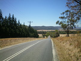
Edward Road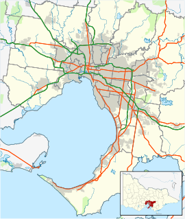
 Chirnside Park
Population: 9092 (2006)[1] Postcode: 3116 Area: 32.1 km² (12.4 sq mi) Location: LGA: Shire of Yarra Ranges State District: Evelyn Federal Division: Casey Suburbs around Chirnside Park: Bend of Islands Coldstream Coldstream Wonga Park Chirnside Park Lilydale Croydon North Croydon Mooroolbark Chirnside Park is a suburb in Melbourne, Victoria, Australia, 33 km north-east from Melbourne's central business district. Its Local Government Area is the Shire of Yarra Ranges. At the 2006 Census, Chirnside Park had a population of 9092.
Contents
Brief history
From 1838 the area formed part of an extensive grazing grant that was developed further by a succession of owners up until the 1920s. The original sub-division of Chirnside Park was, at that time, known as Mooroolbark Park. Around 1000 acres (4 km²) of mainly rich black basaltic soil was grazed and cultivated, watered from two perpetual springs.
In 1921 George Chirnside sold Werribee Park, moving the family's stud herds and the contents of Werribee Mansion to Mooroolbark Park. After George Chirnside's death in 1941, permission to sell the estate was given in 1950 and finalised some years later. Subdivision was approved by the then Shire of Lillydale in 1956 with the residential area, centred on the two storey stone homestead, country club and golf course, named Chirnside Park in 1962 in honour of Thomas Chirnside, who founded the Chirnside empire in 1839.
Amadeo DeVincentiis, an Italian from Abruzzo, also owned great swathes of what is now known as Chirnside Park. However, he sold it for a paltry amount in the 1960s, and within years the fortunate purchasers stood to make thousands. Amadeo attempted to rescind the sale, spending thousands, but failed.
Formally West Lilydale, the surrounding region became known as Chirnside Park in the 1970s, the Post Office opening on 25 September 1979.[2]
Chirnside Park today
Nominally a suburb, Chirnside Park is a satellite community of Lilydale. Thus the services that cannot be met in the nearby shopping complex are found elsewhere. The residential area is set around the large 18-hole golf course, though its future is in doubt. Further residential development exists to the west and north.
In area, however, most of the 'suburb' still retains a rural flavour, extending well into the Yarra Valley to the north, with commercial wineries, orchards and livestock farming, as well as large area residential estates. The Heritage Golf and Country Club, designed by Jack Nicklaus, also nestles in the northwest corner of the suburb directly on the Yarra River.
Chirnside Park Shopping Centre
Chirnside Park Shopping Centre
Schools
Private Schools:
Oxley College (Chirnside Park).
Most Private Schools offer P-12 education.
Government Schools
Chirnside Park Primary School
Sport
The suburb has an Australian Rules football team, The Chirnside Park Panthers, competing in the Eastern Football League.[3]
Golfers play at the Chirnside Park Country Club on Kingswood Drive. [4]
Chirnside Park is also the home of the St Edmunds Basketball Club[1], one of Australia's largest basketball clubs, based out of the Oxley Stadium, competing in the Kilsyth & Mountain District Basketball Association.
References
- ^ Australian Bureau of Statistics (25 October 2007). "Chirnside Park (State Suburb)". 2006 Census QuickStats. http://www.censusdata.abs.gov.au/ABSNavigation/prenav/LocationSearch?collection=Census&period=2006&areacode=SSC21169&producttype=QuickStats&breadcrumb=PL&action=401. Retrieved 2007-10-01.
- ^ Premier Postal History, Post Office List, https://www.premierpostal.com/cgi-bin/wsProd.sh/Viewpocdwrapper.p?SortBy=VIC&country=, retrieved 2008-04-11
- ^ Full Point Footy, Eastern Football League, http://www.fullpointsfooty.net/eastern_football_league.htm, retrieved 2008-10-21
- ^ Golf Select, Chirnside Park, http://www.golfselect.com.au/armchair/courseView.aspx?course_id=651, retrieved 2009-05-11
External links
- St Edmunds 'Saints' Basketball Club
- Oxley College Co-Educational Christian School
- Australian Places - Chirnside Park
- Chirnside Park Primary School
Coordinates: 37°45′14″S 145°19′37″E / 37.754°S 145.327°E
Badger Creek | Beenak | Belgrave | Belgrave Heights | Belgrave South | Big Pats Creek | Cambarville | Chirnside Park | Chum Creek | Coldstream | Dixons Creek | Don Valley | Fernshaw | Ferny Creek | Ferntree Gully | Gilderoy | Gladysdale | Gruyere | Healesville | Hoddles Creek | Kallista | Kalorama | Kilsyth | Launching Place | Lilydale | Macclesfield | McMahons Creek | Matlock | Menzies Creek | Millgrove | Monbulk | Montrose | Mooroolbark | Mount Dandenong | Mount Evelyn | Mount Toolebewong | Narre Warren East | Olinda | Powelltown | Reefton | Sassafras | Selby | Seville | Seville East | Sherbrooke | Silvan | Steels Creek | Tarrawarra | Tecoma | The Patch | Three Bridges | Toorongo | Tremont | Upper Ferntree Gully | Upwey | Wandin East | Wandin North | Warburton | Warburton East | Wesburn | Woori Yallock | Yarra Glen | Yarra Junction | Yellingbo | Yering
Categories:- Suburbs of Melbourne


Wikimedia Foundation. 2010.