- Diemerswil
-
Diemerswil Country Switzerland 
Canton Bern District Bern-Mittelland 47°1′N 7°26′E / 47.017°N 7.433°ECoordinates: 47°1′N 7°26′E / 47.017°N 7.433°E Population 205 (Dec 2010)[1] - Density 73 /km2 (190 /sq mi) Area 2.86 km2 (1.10 sq mi)[2] Elevation 600 m (1,969 ft) Postal code 3053 SFOS number 0536 Surrounded by Kirchlindach, Münchenbuchsee, Schüpfen Website Diemerswil.ch
SFSO statistics
 DiemerswilMap of Diemerswil
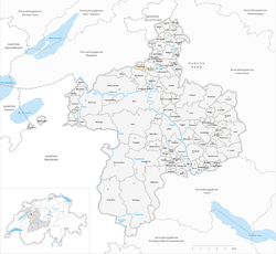
Diemerswil is a municipality in the Bern-Mittelland administrative district in the canton of Bern in Switzerland.
Contents
History
Diemerswil is first mentioned in 1257 as Diemarswile.[3]
Geography
Diemerswil has an area, as of 2009[update], of 2.86 km2 (1.10 sq mi). Of this area, 2.08 km2 (0.80 sq mi) or 72.7% is used for agricultural purposes, while 0.56 km2 (0.22 sq mi) or 19.6% is forested. Of the rest of the land, 0.17 km2 (0.066 sq mi) or 5.9% is settled (buildings or roads).[4]
Of the built up area, housing and buildings made up 2.4% and transportation infrastructure made up 3.1%. 19.2% of the total land area is heavily forested. Of the agricultural land, 58.4% is used for growing crops and 11.9% is pastures, while 2.4% is used for orchards or vine crops.[4]
Diemerswil is located on the south east side of the Moos Lake valley and includes the hamlets of Dörfli, Kohlholz, Mettlen, Moos, Riedmatt and Wydacker. It belongs to the parish and greater community (Gemeindeverband) of Münchenbuchsee.
Demographics
Diemerswil has a population (as of 31 December 2010) of 205.[1] As of 2007[update], 1.0% of the population was made up of foreign nationals. Over the last 10 years the population has grown at a rate of 17.2%. Most of the population (as of 2000[update]) speaks German (97.6%), with French being second most common (1.8%) and Portuguese being third (0.6%).
In the 2007 election the most popular party was the SVP which received 48.9% of the vote. The next three most popular parties were the FDP (15.7%), the SPS (14.1%) and the Green Party (13%).
The age distribution of the population (as of 2000[update]) is children and teenagers (0–19 years old) make up 25.1% of the population, while adults (20–64 years old) make up 64.1% and seniors (over 64 years old) make up 10.8%. The entire Swiss population is generally well educated. In Diemerswil about 91.7% of the population (between age 25-64) have completed either non-mandatory upper secondary education or additional higher education (either university or a Fachhochschule).
Diemerswil has an unemployment rate of 0%. As of 2005[update], there were 39 people employed in the primary economic sector and about 12 businesses involved in this sector. 4 people are employed in the secondary sector and there are 2 businesses in this sector. 9 people are employed in the tertiary sector, with 4 businesses in this sector.[5]
The historical population is given in the following table:[3]
year population 1764 125 1850 245 1880 282 1900 250 1920 249 1950 208 1980 145 2000 167 References
- ^ a b Swiss Federal Statistical Office - STAT-TAB, online database – Datenwürfel für Thema 01.2 - Bevölkerungsstand und -bewegung (German) accessed 29 September
- ^ Arealstatistik Standard - Gemeindedaten nach 4 Hauptbereichen
- ^ a b Diemerswil in German, French and Italian in the online Historical Dictionary of Switzerland.
- ^ a b Swiss Federal Statistical Office-Land Use Statistics 2009 data (German) accessed 25 March 2010
- ^ Swiss Federal Statistical Office accessed 08-Jun-2009
External links
- Diemerswil in German, French and Italian in the online Historical Dictionary of Switzerland.
Categories:- Municipalities of Bern
- Municipalities of Switzerland


Wikimedia Foundation. 2010.