- List of Sites of Special Scientific Interest in Cheshire
-

There are 63 Sites of Special Scientific Interest (SSSIs) in Cheshire, England, covering a total area of 19,844 hectares (49,035 acres). Of these, 52 have been designated for their biological interest, seven for their geological or geomorphological features, and five for both.[1]
SSSIs are governed by the Wildlife and Countryside Act 1981, which mandates that sites be selected for their "flora, fauna, or geological or physiographical features".[2] The body responsible for designating biological SSSIs in England is Natural England,[3] which took over the role of designating and managing SSSIs from English Nature on its creation in 2006. Earth sciences SSSIs are notified separately by the Joint Nature Conservation Committee across the entire UK via Geological Conservation Review.[4] Natural England, like its predecessor bodies, uses a system of areas termed "Areas of Search", which broadly correspond with the 1974–1996 counties,[2] and for consistency the same approach is followed here. In the case of Cheshire, the Area of Search differs from the modern ceremonial county boundary. Since the 1990s, nature conservation in England has also focused on 120 natural areas: regions defined by natural features rather than by administrative boundaries.[5][6] The Cheshire Area of Search encompasses four natural areas.[1][7]
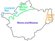 Sketch map showing the broad locations of the four natural areas
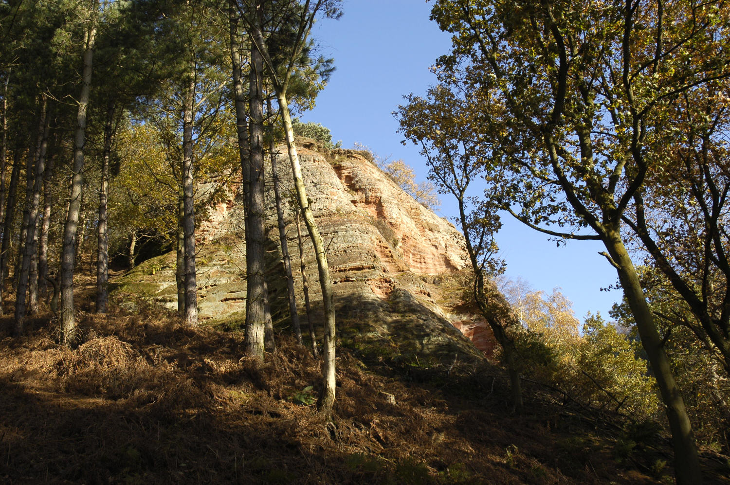
The majority of the SSSIs fall within the Meres and Mosses natural area, which covers the bulk of the county, extending into Shropshire and Staffordshire to the south.[1][6] This region is dominated by the Cheshire Plain, a wide expanse of flat or gently undulating farmland which rarely rises above 100 metres in elevation. Despite intensive agricultural use, diverse wetland habitats survive including mosses (bogs), swamps, fens, meres and thousands of ponds. Flashes, originating in subsidence after salt extraction, contain examples of inland salt marsh, an extremely rare habitat internationally.[6] Ancient woodland is sparse throughout this area, but is found on the slopes of the Mid Cheshire Ridge and in river valleys towards the north of the county. The lowland heath habitat is very rare, occurring only at a handful of sites. The Mid Cheshire Ridge rises abruptly in the middle of the plain, with a high point of 227 metres; its Triassic sandstones are exposed at the Raw Head geological site.[6]
 Raw Head is one of the area's geological SSSIs
Two extensive sites, Goyt Valley and Leek Moors, lie at the eastern edge of the county and the south-western end of the Pennines, within the South West Peak natural area of the Peak District.[1][8] At a significantly higher elevation than the other Cheshire SSSIs and underlain by millstone grit and shale, they contain a variety of upland habitats, predominantly heather moorland, grassland and blanket mire.[8]
Ten SSSIs are located in Warrington and the former boroughs of Halton and Ellesmere Port & Neston, in the north-west of the county. These fall within the Urban Mersey Basin natural area, which also covers Greater Manchester and Merseyside. Although the area as a whole is one of the most densely populated regions in Europe, much of the area within Cheshire is farmland. Semi-natural habitats here include ancient woodland, raised bog and freshwater wetland. The Rixton Clay Pits site represents former industrial land, and railway cuttings expose geological features.[1][9] Finally, the Liverpool Bay coastal region contains two estuaries, the Mersey and Dee, which are Cheshire's largest SSSIs.[1][10]
Sites
A–F
Site name Reason for Designation Area[A] Grid reference[B] Year in which notified Map[C] Citation[D] Biological Geological Hectares Acres Abbots Moss 
38.4 94.8 SJ597690 1984 [3] [4] Alderley Edge 93.6 231.2 SJ848776 1951 [5] [6] Bagmere 26.9 66.3 SJ795643 1963 [7] [8] Bar Mere 12.8 31.5 SJ536478 1979 [9] [10] Beechmill Wood And Pasture 6.2 15.4 SJ540768 1979 [11] [12] Betley Mere 29.6 73.2 SJ747480 1963 [13] [14] Bickerton Hill 91.0 224.8 SJ498530 1979 [15] [16] Black Lake, Delamere 1.7 4.3 SJ537709 1963 [17] [18] Brookhouse Moss 10.1 24.9 SJ806617 1979 [19] [20] Chapel Mere 11.8 29.1 SJ540518 1987 [21] [22] Comber Mere 65.0 160.5 SJ585442 1963 [23] [24] Dane-In-Shaw Pasture 8.2 20.2 SJ877625 1990 [25] [26] Danes Moss 51.3 126.8 SJ905704 1985 [27] [28] Dee Cliffs, Farndon 2.0 5.0 SJ414542 1979 [29] [30] Dee Estuary 5241.2 12951.2 SJ240804 1954 [31] [32] Dunsdale Hollow 6.9 17.0 SJ513763 1987 [33] [34] Flaxmere Moss 7.0 17.2 SJ556723 1965 [35] [36] Flood Brook Clough 5.1 12.6 SJ532800 1979 [37] [38] Frodsham Railway And Road Cuttings 1.3 3.3 SJ520780 1979 [39] [40] G–L
Site name Reason for Designation Area[A] Grid reference[B] Year in which notified Map[C] Citation[D] Biological Geological Hectares Acres Gannister Quarry 1.6 4.0 SJ869592 1985 [41] [42] Gleads Moss 2.8 6.9 SJ821685 1979 [43] [44] Goyt Valley 1332.6 3292.9 SK028746 1951 [45] [46] Hallwood Farm Marl Pit 0.1 0.3 SJ343759 1986 [47] [48] Hatch Mere 13.3 32.7 SJ551721 1951 [49] [50] Hatherton Flush 1.9 4.8 SJ671482 1985 [51] [52] Hatton's Hey Wood, Whittle's Corner And Bank Rough 23.7 58.5 SJ570770 1979 [53] [54] Holcroft Moss 18.1 44.7 SJ685932 1991 [55] [56] Holly Banks[E] 9.3 23.1 SJ815659 1979 [57] [58] Inner Marsh Farm 22.5 55.6 SJ307733 1998 [59] [60] Leek Moors 3970.8 9812.1 SK010649 1954 [61] [62] Lindow Common 17.7 43.7 SJ834811 1963 [63] [64] Linmer Moss 2.4 5.8 SJ547707 1994 [65] [66] Little Budworth Common 54.4 134.3 SJ585655 1979 [67] [68] M–R
Site name Reason for Designation Area[A] Grid reference[B] Year in which notified Map[C] Citation[D] Biological Geological Hectares Acres Madams Wood 9.5 23.4 SJ877650 1990 [69] [70] Mersey Estuary 6714.5 16591.9 SJ395818 1951 [71] [72] Norbury Meres 23.7 58.6 SJ559492 1979 [73] [74] Oak Mere 68.8 169.9 SJ574677 1986 [75] [76] Oakhanger Moss 14.4 35.6 SJ767550 1994 [77] [78] Peckforton Woods 57.9 143 SJ531576 1984 [79] [80] Pettypool Brook Valley 46.7 115.3 SJ617702 1951 [81] [82] Plumley Lime Beds 23.3 57.5 SJ707750 1963 [83] [84] Quoisley Meres 28.3 70.0 SJ548455 1963 [85] [86] Raw Head 13.5 33.4 SJ508544 1979 [87] [88] Red Brow Cutting 0.2 0.4 SJ567816 1991 [89] [90] Risley Moss 83.8 207.1 SJ667917 1986 [91] [92] River Dane[E] 295.8 730.8 SJ808661 1994 [93] [94] River Dee (England) 371.5 917.9 SJ407658 1996 [95] [96] Rixton Clay Pits 13.7 33.7 SJ685901 1979 [97] [98] Roe Park Woods 35.4 87.5 SJ858583 1990 [99] [100] Rostherne Mere 152.5 376.8 SJ743842 1984 [101] [102] S–Z
Site name Reason for Designation Area[A] Grid reference[B] Year in which notified Map[C] Citation[D] Biological Geological Hectares Acres Sandbach Flashes 157.1 388.2 SJ726607 1963 [103] [104] Sound Heath 4.8 11.9 SJ620479 1963 [105] [106] Tabley Mere 44.9 110.9 SJ723768 1963 [107] [108] Tatton Meres 90.3 223.2 SJ755799 1963 [109] [110] Taylor's Rough & Wellmeadow Wood 6.5 16.0 SJ493453 1979 [111] [112] The Mere, Mere 19.4 48.0 SJ732818 1985 [113] [114] Warburton's Wood And Well Wood 6.9 17.0 SJ554761 1979 [115] [116] Well Rough And Long Plantation 8.6 21.2 SJ455443 1979 [117] [118] Wettenhall And Darnhall Woods 45.3 111.9 SJ649626 1979 [119] [120] Wimboldsley Wood 16.4 40.6 SJ672643 1979 [121] [122] Witton Lime Beds 16.4 40.5 SJ660749 1979 [123] [124] Woolston Eyes 269.8 666.7 SJ662885 1985 [125] [126] Wybunbury Moss 23.2 57.4 SJ696501 1951 [127] [128] Notes
All tabulated data are sourced from the Natural England website, and were last updated on 1 March 2010.[11][12]
A Data rounded to one decimal place. Area in acres converted from hectare value.
B Grid reference is based on the British national grid reference system, also known as OSGB36, and is the system used by the Ordnance Survey.[13]
C Link to maps using the Nature on the Map service provided by Natural England.[14]
D Natural England citation sheets for each SSSI.
E The River Dane and Holly Banks SSSIs overlap.
References
- ^ a b c d e f "Sites of Special Scientific Interest: Cheshire". Natural England. http://www.sssi.naturalengland.org.uk/Special/sssi/searchresults.cfm?sssi_name=&frmcounty=1006. Retrieved 2010-04-13.
- ^ a b Guidelines for the Selection of Biological SSSIs, Part A: "Rationale". (Nature Conservancy Council; 1989) (ISBN 086139 544 1). Downloaded from [1], 14 April 2010.
- ^ "Notification of SSSIs". Natural England. http://www.sssi.naturalengland.org.uk/special/sssi/notification.cfm. Retrieved 2006-08-01.
- ^ Joint Nature Conservation Committee: Geological Conservation Review (GCR) (accessed 14 April 2010)
- ^ Natural England: Natural Areas (accessed 15 April 2010)
- ^ a b c d English Nature: Meres and Mosses (27 February 1998) (accessed 10 April 2010)
- ^ Natural England: Natural Areas: Search Natural Areas (accessed 15 April 2010)
- ^ a b Natural England: The South West Peak Natural Area Profile (accessed 13 April 2010)
- ^ English Nature: The Urban Mersey Basin Natural Area: A Nature Conservation Profile (March 1997) (accessed 13 April 2010)
- ^ Natural England: Liverpool Bay Natural Area: A nature conservation profile (29 October 1997) (accessed 14 April 2010)
- ^ SSSI background data (Cheshire) – compiled 01 Mar 2010. Retrieved from [2]; 11 April 2010.
- ^ Natural England citation sheets for each SSSI. Retrieved 13 April 2010.
- ^ "Guide to National Grid". Ordnance Survey. http://www.ordnancesurvey.co.uk/oswebsite/getamap/help.html#gridref. Retrieved 2006-08-07.
- ^ Natural England: Nature on the Map: Welcome to Nature on the Map (accessed 15 April 2010)
Categories:- Sites of Special Scientific Interest in Cheshire
- Lists of SSSIs by Area of Search


Wikimedia Foundation. 2010.