- Oakhanger, Cheshire
-
Coordinates: 53°05′N 2°21′W / 53.08°N 2.35°W
Oakhanger 
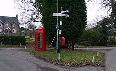
Old phonebox and signpost in centre of Oakhanger
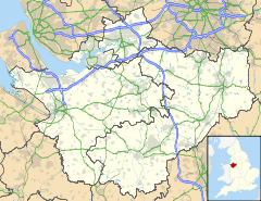
 Oakhanger shown within Cheshire
OS grid reference SJ7654 Parish Haslington Unitary authority Cheshire East Ceremonial county Cheshire Region North West Country England Sovereign state United Kingdom Post town Crewe Postcode district CW1 Dialling code 01270 Police Cheshire Fire Cheshire Ambulance North West EU Parliament North West England List of places: UK • England • Cheshire Oakhanger is a village in Cheshire, England, within the civil parish of Haslington and the Borough of Cheshire East, located off the B5077 road between Alsager and Crewe.
Oakhanger Moss
Oakhanger Moss is a Site of Special Scientific Interest SSSI covering 13.58ha. English Nature reports that it was originally a mere within a glacial hollow; since the 17th century the water has become filled with vegetation creating a raised peat bog. Adders can be found on the site. Neighbouring sites such as White Moss have been excavated for commercial peat production.
External links
- English Nature:Oakhanger SSSI, http://www.english-nature.org.uk/citation/citation_photo/1006639.pdf, retrieved 30 August 2009
Categories:- Villages in Cheshire
- Cheshire geography stubs
Wikimedia Foundation. 2010.

