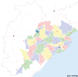
- Nilagiri
-
Nilagiri — town — Coordinates 21°28′N 86°46′E / 21.46°N 86.77°ECoordinates: 21°28′N 86°46′E / 21.46°N 86.77°E Country India State Orissa District(s) Balasore Population 14,745 (2001[update]) Time zone IST (UTC+05:30) Area
• 23 metres (75 ft)
Nilagiri(Oriya: ନିଳଗିରି) (also called Nilgiri) is a town and a notified area committee in Balasore district in the Indian state of Orissa.
Contents
History
Orissa Freedom Fighters like Banamali Das, Baishnab Patnaik and Nanda Kishore Patnaik violently fought against the local prince and forced him to surrender to newly formed Indian National Government. This was the beginning of the process of 576 princely states joining Republic of India and thus the making of modern political India. In Orissa, people of Nilagiri celebrate this as The Victorious Uprising of Nilagiri. see also Nilgiri State.
"Santaragadia" is a semi town in the part of Nilagiri sub-division.it is located 11 k.m from nilagiri.Biju Road is connecting Nilagiri to Santaragadia, there was freedom fighters like Bhagwan Pradhan(Patanapada), Baidyanath Panigrahi.
Panchalingeshwar is located 8 k.m from nilagiri..it is famous for Place of "Lord Shiva temple" and water fall on hill side.
"Santaragadia" mostly known as a Place-based education, sometimes called pedagogy of place, place-based learning, experiential education, community-based education, education for sustainability, environmental education or more rarely, service learning, is an educational philosophy developed initially by The Oriya Society.
Basically "Santaragadia" is the Place-based education is often hands-on, project-based and always related to something in the real Nilagiri and Balasore District also. Thus students are embarking upon a unit about Literacy
In a larger sense however, place-based education seeks to help communities through employing students and school staff in solving community problems.
Geography
Nilagiri is located at 21°28′N 86°46′E / 21.46°N 86.77°E.[1] It has an average elevation of 23 m (75 ft).
Demographics
As of 2001[update] India census,[2] Nilagiri had a population of 14,745. Males constitute 51% of the population and females 49%. Nilagiri has an average literacy rate of 60%, higher than the national average of 59.5%: male literacy is 66%, and female literacy is 54%. In Nilagiri, 13% of the population is under 6 years of age.
There is a Jagannatha Temple in Nilagiri [3] which is one of the prominent Jagannnath temples of Orissa. Lord Jagannath, Balabhadra and Subhadra are worshiped here. Every year Ratha Yatra is observed with all the cults of the gods.
Panchalingeswara temple is scenic picnic spot in Baleswar which is located 30 kms from Baleswar.[4] This is famous both for Panchalingeswara temple and the picnic spot nearby. There is a state tourism Pantha Nivas in Panchalingeswara for the tourists coming from outside. Panchalingeswara is sorrounded by thick greenery and hillocks. Branches of the natural spring flow through the hill range which add more attraction to this place.
Politics
Current MLA from Nilgiri Assembly Constituency is Pratap Chandra Sarangi of BJP, who won the seat in State elections in 2004. He is from village Gopinathpur. Previous MLAs from this seat were Pradipta Panda of CPI(M) in 2000, Akshaya Kumar Acharya representing INC in 1995 and representing INC(I) in 1980, Chittaranjan Sarangi as independent candidate in 1990, Sukumar Nayak of INC in 1985, Rajendra Chandra Mardaraj of JNP in 1977.[5]
Nilgiri is part of Baleshwar(Lok Sabha constituency).[6]
References
- ^ Falling Rain Genomics, Inc - Nilagiri
- ^ "Census of India 2001: Data from the 2001 Census, including cities, villages and towns (Provisional)". Census Commission of India. Archived from the original on 2004-06-16. http://web.archive.org/web/20040616075334/http://www.censusindia.net/results/town.php?stad=A&state5=999. Retrieved 2008-11-01.
- ^ http://baleswar.nic.in/history_culture.htm
- ^ http://www.orissa-tourism.com/bsore.html
- ^ "State Elections 2004 - Partywise Comparison for 17-Nilgiri Constituency of ORISSA". Election Commission of India. http://archive.eci.gov.in/March2004/pollupd/ac/states/s18/Partycomp17.htm. Retrieved 2008-09-15.
- ^ "Assembly Constituencies - Corresponding Districts and Parliamentary Constituencies of Orissa". Election Commission of India. http://archive.eci.gov.in/se2000/background/S18/Orissa_AC_Dist_PC.pdf. Retrieved 2008-09-15.
Baleswar Related topics Kirtania portCities and towns
in other districtsAngul · Balangir · Bargarh · Bhadrak · Boudh · Cuttack · Debagarh · Dhenkanal · Gajapati · Ganjam · Jagatsinghpur · Jajpur · Jharsuguda · Kalahandi · Kandhamal · Kendrapara · Kendujhar · Khordha · Koraput · Malkangiri · Mayurbhanj · Nabarangpur · Nayagarh · Nuapada · Puri · Rayagada · Sambalpur · Subarnapur · Sundergarh
Categories:- Cities and towns in Balasore district
Wikimedia Foundation. 2010.


