- Ermenek
-
Ermenek — District — Location of Ermenek within Turkey.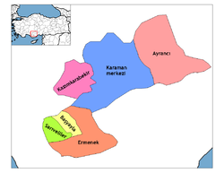
Coordinates: 36°38′N 32°53′E / 36.633°N 32.883°E Country  Turkey
Province Karaman Government – Mayor Necati Akpınar (AKP) Elevation 1,196 m (3,924 ft) Population (2000)[1] – District 42,643 – Urban 15,509 Time zone EET (UTC+2) – Summer (DST) EEST (UTC+3) Postal code 70xxx Area code(s) 0338 Licence plate 70 Website www.ermenek.gov.tr Ermenek is a town and district of Karaman Province in the Central Anatolia region of Turkey. According to 2000 census, population of the district is 42,643 of which 15,509 live in the town of Ermenek.[1][2]
Contents
Name
The town was historically known as Germanicopolis (Greek: Γερμανικόπολις); Germanig, and possibly Clibanus[3]; and much later as Ermenak.
History
Germanicopolis was a town in ancient Isauria. (Hierocl. p. 709; Concil. Chalced. p. 659; Const. Porphyr. de Them. i. 13.) The city took its name from Germanicus, grandson of Augustus.
Four of its bishops are known during the Byzantine government: Tyrannus, 451; Eustathius, 797; Basil, 878 (Le Quien, Or. christ., II, 1027); and Bisulas in the sixth century (Brooks, Sixth Book of the Letters of Severus, 13, 26, 80). The crusaders sustained a great defeat near the city in 1098. It then passed into the power of the Armenian dynasty of the Rubenid, who called it Germanig, whence is derived the present name of Ermenek. The Turks took possession of it in 1228. It is situated at a height of 1362 feet. The ruins of many Roman monuments and a stronghold are still to be seen on the mountain.
Geography
Villages in the Ermenek district include:
- Güneyyurt, (municipality)
- Kazancı, (municipality)
- Ağaççatı
- Ardiçkaya
- Aşağı Çağlar
- Balkusan
- Boyalık
- Çamlıca
- Çatalbadem
- Çavuş
- Eskice
- Evsin
- Elmayurdu
- Görmeli
- Gökçeseki
- Gökçekent
- İkizçınar
- Katranlı
- Kayaönü
- Olukpınar
- Pamuklu
- Pinarönü
- Sarıvadi
- Tepebaşı
- Yalındal
- Yaylapazarı
- Yerbağ
- Yeşilköy
- Yukarı Çağlar
Notes
- ^ a b Turkish Statistical Institute. "Census 2000, Key statistics for urban areas of Turkey" (in Turkish) (XLS). http://www.die.gov.tr/nufus_sayimi/2000tablo5.xls. Retrieved 2008-03-20.
- ^ GeoHive. "Statistical information on Turkey's administrative units" (in English). http://www.xist.org/cntry/turkey.aspx?levels=Ic%20Anadolu. Retrieved 2008-03-20.
- ^ Richard Talbert, Barrington Atlas of the Greek and Roman World, (ISBN 0-691-03169-X), Map 66 & text.
References
 This article incorporates text from a publication now in the public domain: Smith, William, ed (1854–57). "article name needed". Dictionary of Greek and Roman Geography. London: John Murray.
- This article incorporates text from a publication now in the public domain: Herbermann, Charles, ed (1913). Catholic Encyclopedia. Robert Appleton Company.
- Falling Rain Genomics, Inc. "Geographical information on Ermenek, Turkey" (in English). http://www.fallingrain.com/world/TU/0/Ermenek.html. Retrieved 2008-03-16.
- Ermenek at GEOnet Names Server
External links
- District governor's official website (Turkish)
- District municipality's official website (Turkish)
- A web portal about Ermenek
 Ermenek in Karaman Province (in the Central Anatolia region) of Turkey
Urban districts 
Rural districts RegionsAegean Black Sea Central Anatolia Eastern Anatolia Marmara Mediterranean Southeastern Anatolia Coordinates: 36°38′20″N 32°53′33″E / 36.63889°N 32.8925°E
Categories:- Districts of Karaman
- Central Anatolia Region
- Isauria
- Roman towns and cities in Turkey
- Ancient Greek sites in Turkey
- Populated places in Karaman Province
- Central Anatolia Region geography stubs

Wikimedia Foundation. 2010.