- North Shropshire
-
Coordinates: 52°51′22″N 2°43′23″W / 52.856°N 2.723°W
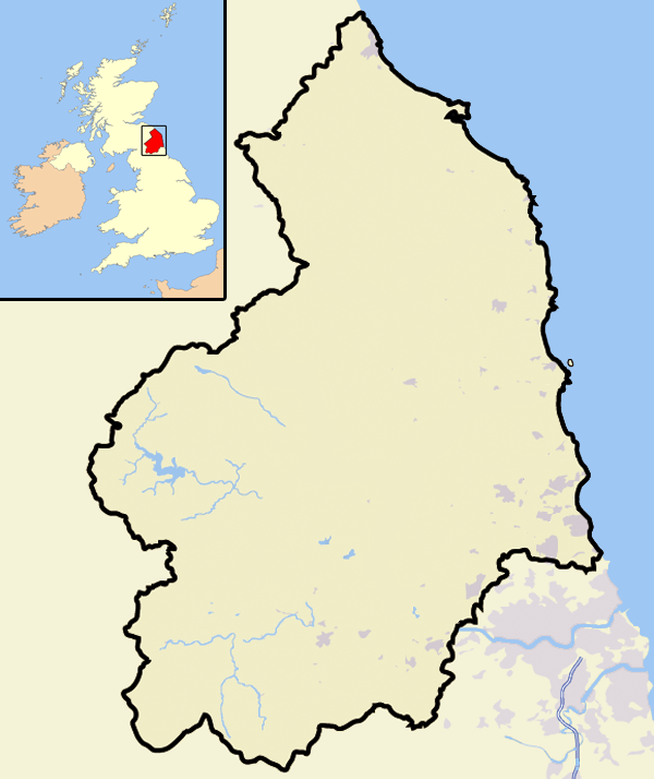
North Shropshire District 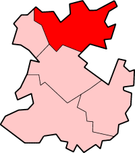
Shown within Shropshire non-metropolitan countyGeography Status District HQ Wem ONS code 39UC History Origin Market Drayton Rural District
North Shropshire Rural DistrictCreated 1974 Abolished 2009 Succeeded by Shropshire Politics Governance North Shropshire District Council North Shropshire was a local government district in Shropshire, England. The district council was based at Edinburgh House, in Wem. Other settlements included the towns of Ellesmere, Market Drayton, Wem and Whitchurch, as well as the large villages of Shawbury and Baschurch. The district bordered onto Wales, Cheshire and Staffordshire as well as the Shropshire districts of Oswestry, Shrewsbury and Atcham and the unitary Telford and Wrekin.
The district was formed on 1 April 1974, under the Local Government Act 1972, by a merger of Market Drayton Rural District and North Shropshire Rural District. As of 2008 it was entirely surrounded by boroughs (including the county borough of Wrexham).
The district and its council were abolished on 1 April 2009 when the new Shropshire unitary authority was established, as part of the 2009 structural changes to local government in England.
Contents
Settlements
The district council classified Wem, Market Drayton, Whitchurch and Ellesmere as the market towns of North Shropshire, while it gave the classification of "main service villages" to Baschurch, Cheswardine, Clive, Cockshutt, Dudleston Heath, Hadnall, Hinstock, Hodnet, Prees, Shawbury, Tilstock, Welshampton and Woore. There are many other smaller villages and hamlets.
Infrastructure
The main roads in the district are the A41, A49 and the A53. There are no motorways.
There are four railway stations in the district - Yorton, Wem, Prees and Whitchurch - all on the Welsh Marches Line. The Shrewsbury to Chester Line runs through the district too, but the station at Baschurch has closed. The Shropshire Union Canal goes through the district too, passing Market Drayton at one point. The Ellesmere Canal/Llangollen Canal is the other canal in the district.
See also
- North Shropshire constituency - the name of the UK Parliament constituency which covers the former North Shropshire district and also the former Oswestry borough.
- Parishes in North Shropshire - the main subdivisions used within the district.
External links
- Shropshire Tourism Information on North Shropshire - facts, history, attractions
- shropshirelive.com - News and information for Shropshire
Bedfordshire Abolished NewExisting (1990s)
Cheshire Abolished NewExisting (1990s)Warrington • Halton
Cornwall Abolished NewExisting (1890s)
County Durham Abolished NewExisting (1990s)
Northumberland Abolished NewExisting (1990s)None
Shropshire Abolished NewExisting (1990s)
Wiltshire Abolished NewWiltshireExisting (1990s)Categories:
- Districts of England established in 1974
- English districts abolished in 2009
- History of Shropshire
- Local government in Shropshire
- Former non-metropolitan districts of Shropshire


Wikimedia Foundation. 2010.