- Nanda Devi National Park
-
Nanda Devi and Valley of Flowers National Parks * UNESCO World Heritage SiteCountry India Type natural Criteria vii, x Reference 335 Region ** Asia-Pacific Inscription history Inscription 1988 (12th Session) Extensions 2005 * Name as inscribed on World Heritage List
** Region as classified by UNESCONanda Devi National Park IUCN Category Ia (Strict Nature Reserve)Location Uttarakhand, India Coordinates 30°25′7″N 79°50′59″E / 30.41861°N 79.84972°ECoordinates: 30°25′7″N 79°50′59″E / 30.41861°N 79.84972°E Area 630.33 km² Established 1982 The Nanda Devi National Park is a national park situated around the peak of Nanda Devi, 7,817 m (25,646 ft), in the state of Uttarakhand in northern India. It was established as national park in 1982. Along with the adjoining Valley of Flowers National Park to the northwest, it was inscribed a World Heritage Site by UNESCO in 1988.[1]. It covers 630.33 km²[2] Both parks are encompassed in the Nanda Devi Biosphere Reserve (223,674 ha) which is further surrounded by a buffer zone (5,148.57 km²).[2] This Reserve is in the UNESCO World Network of Biosphere Reserves since 2004.
The park encompasses the Nanda Devi Sanctuary, a glacial basin surrounded by a ring of peaks between 6,000 metres (19,700 ft) and 7,500 m (24,600 ft) high, and drained by the Rishi Ganga through the Rishi Ganga Gorge, a steep, almost impassable defile. The entire park lies at an elevation of more than 3,500 m (11,500 ft) above mean sea level.
Contents
Layout of the Sanctuary
 Contour map of the Sanctuary
The Sanctuary can be divided into two parts, Inner and Outer. Together, they are surrounded by the main Sanctuary Wall, which forms a roughly square outline, with high, continuous ridges on the north, east, and south sides. On the west side, less high but still imposing ridges drop from the north and south toward the Rishi Ganga Gorge, which drains the Sanctuary towards the west.[3]
The Inner Sanctuary occupies roughly the eastern two-thirds of the total area, and contains Nanda Devi itself and the two major glaciers flanking the peak, the Uttari (north) Rishi Glacier and the Dakkhni (south) Rishi Glacier. These are fed by the smaller Uttari Nanda Devi and Dakkhni Nanda Devi Glaciers respectively.[3] The first recorded entry of humans into the Inner Sanctuary was by Eric Shipton and H. W. Tilman in 1934, via the Rishi Gorge.[4]
The Outer Sanctuary occupies the western third of the total Sanctuary, and is separated from the Inner Sanctuary by high ridges, through which flows the Rishi Ganga. It is split in two by the Rishi Ganga; on the north side lies the Ramani Glacier, flowing down from the slopes of Dunagiri and Changabang, and on the south lies the Trisul Glacier, flowing from the peak of the same name. This portion of the Sanctuary is accessible to the outside (though requiring the crossing of a 4,000 m (13,000 ft) pass). The first serious climbing expedition to pass through the Outer Sanctuary was that of T. G. Longstaff, who climbed Trisul I in 1907 via the eponymous glacier.[4]
Named peaks of the Park and environs
Within the Sanctuary
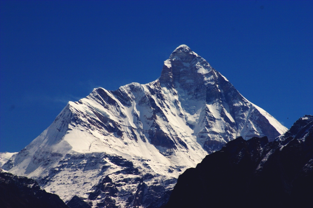
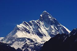 Nanda Devi peak
Apart from Nanda Devi, the following peaks lie on ridges dividing the Inner and Outer Sanctuary areas.
- Nanda Devi: 7,816 m (25,643 ft)
- Devistan I, II: 6,678 metres (21,909 ft), 6,529 m (21,421 ft)
- Rishi Kot: 6,236 m (20,459 ft)
On the Sanctuary Wall
These peaks are listed in clockwise order, starting from just north of the Rishi Gorge. Some of them are relatively minor summits and have small topographic prominence, while others are independent peaks.
- Hanuman: 6,075 m (19,931 ft)
- Dunagiri: 7,066 m (23,182 ft)
- Changabang: 6,864 m (22,520 ft)
- Kalanka: 6,931 m (22,740 ft)
- Rishi Pahar: 6,992 m (22,940 ft)
- Mangraon: 6,568 m (21,549 ft)
- Deo Damla: 6,620 m (21,719 ft)
- Bamchu: 6,303 m (20,679 ft)
- Sakram: 6,254 m (20,518 ft)
- Latu Dhura: 6,392 m (20,971 ft)
- Nanda Devi East: 7,434 m (24,390 ft)
- Nanda Khat: 6,611 m (21,690 ft)
- Panwali Doar (or "Panwali Dwar"): 6,663 m (21,860 ft)
- Maiktoli: 6,803 m (22,320 ft)
- Devtoli: 6,788 m (22,270 ft)
- Mrigthuni: 6,855 m (22,490 ft)
- Trisul I, II, III: 7,120 metres (23,360 ft), 6,690 metres (21,949 ft), 6,008 m (19,711 ft)
- Bethartoli Himal: 6,352 m (20,840 ft)
Just outside the Wall
The following are the most notable peaks which are adjacent to the wall; they are all connected to the Wall by high passes. They lie just outside the boundaries of the Park.
- Hardeol: 7,151 m (23,461 ft) (northeast corner)
- Trishuli: 7,074 m (23,209 ft) (just beyond Hardeol)
- Nanda Kot: 6,861 m (22,510 ft) (southeast corner)
- Nanda Ghunti: 6,309 m (20,699 ft) (southwest corner)
References
- ^ Official UNESCO site
- ^ a b World Conservation Monitoring Centre
- ^ a b Garhwal-Himalaya-Ost, 1:150,000 scale topographic map, prepared in 1992 by Ernst Huber for the Swiss Foundation for Alpine Research, based on maps of the Survey of India.
- ^ a b H. W. Tilman, The Ascent of Nanda Devi, Cambridge University Press, 1937. Reprinted in The Seven Mountain-Travel Books, The Mountaineers, Seattle, 2003, ISBN 0-89886-960-9.
External links
 • Part of the series on National Parks of India •
Andaman &
Nicobar IslandsAndhra Pradesh Arunachal Pradesh Assam Bihar Valmiki• Kanwar Taal Bird Sanctuary • Vikramshila Dolphin SanctuaryChhattisgarh Goa Gujarat Haryana Himachal Pradesh Jammu & Kashmir Jharkhand Karnataka Kerala Madhya Pradesh Maharashtra Manipur Meghalaya Mizoram Nagaland Orissa Rajasthan Sikkim Tamil Nadu Uttar Pradesh Uttarakhand West Bengal World Heritage Sites in India North Agra Fort · Buddhist Monuments at Sanchi · Fatehpur Sikri · Humayun's Tomb · Keoladeo National Park · Khajuraho Group of Monuments · Mountain Railways of India (Kalka-Shimla Railway)1 · Nanda Devi and Valley of Flowers National Parks · Qutub Minar and its Monuments · The Red Fort complex · Rock Shelters of Bhimbetka · Taj Mahal

Northeast East Mahabodhi Temple Complex at Bodh Gaya · Mountain Railways of India (Darjeeling Himalayan Railway)1 · Sun Temple at Konark · Sundarbans National Park
South Great Living Chola Temples at Thanjavur, Gangaikonda Cholapuram and Darasuram · Group of Monuments at Hampi · Group of Monuments at Mahabalipuram · Group of Monuments at Pattadakal · Mountain Railways of India (Nilgiri Mountain Railway)1
West Ajanta Caves · Champaner-Pavagadh Archaeological Park · Chhatrapati Shivaji Terminus · Churches and convents of Goa · Elephanta Caves · Ellora Caves · Jantar Mantar
1 Shared with other region/sCategories:- IUCN Category Ia
- National parks of Uttarakhand
- Protected areas established in 1982
- World Heritage Sites in India


Wikimedia Foundation. 2010.