- Dunagiri (mountain)
-
For the area in Uttarakhand, see Dunagiri.
Dunagiri 
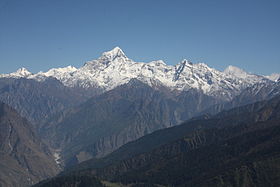
The Dunagiri from Kuari-PassElevation 7,066 m (23,182 ft) Prominence c. 1,200 m (3,900 ft) [1] Location Location in northern India Location Uttarakhand, India Range Nanda Devi Group, Garhwal Himalayas Coordinates 30°31′57″N 79°50′02″E / 30.5325°N 79.83389°ECoordinates: 30°31′57″N 79°50′02″E / 30.5325°N 79.83389°E Climbing First ascent July 5, 1939 by André Roch, F. Steuri, D. Zogg[2] Easiest route southwest ridge: rock/snow/ice climb Dunagiri (7,066 m) is one of the high peaks of the Garhwal Himalayas in the northern Indian state of Uttarakhand. It lies at the northwest corner of the Sanctuary Wall, a ring of peaks surrounding Nanda Devi and enclosing the Nanda Devi Sanctuary.
Dunagiri was first climbed on July 5, 1939[3] by the Swiss climbers André Roch, F. Steuri, and D. Zogg, via the southwest ridge. In 1975, Joe Tasker and Dick Renshaw climbed a particularly difficult route on the southeast buttress in a significant milestone for alpine-style climbing.[4] In 1978 the first Australian Himalayan expedition made the fourth ascent via the south-west ridge[5].
References
- ^ This is an approximate figure, based on the 1:150,000 scale topographic map Garhwal-Himalaya-Ost, Swiss Foundation for Alpine Research.
- ^ Jill Neate. High Asia: An Illustrated History of the 7000 Metre Peaks. ISBN 0-89886-238-8.
- ^ Some sources say 1947.
- ^ Andy Fanshawe and Stephen Venables, Himalaya Alpine-Style, Hodder and Stoughton, 1995, ISBN 0-340-64931-3
- ^ Steffen, Will (2010). Himalayan Dreaming: Austrlaian mountatineering in the great ranges of Asia 1922-1990. Canberra: ANU E Press. pp. 593. ISBN 9781921666162.
Categories:- Almora
- Mountains of Uttarakhand
- Uttarakhand geography stubs
Wikimedia Foundation. 2010.

