- Hannō, Saitama
-
Hannō
飯能市— City — 
FlagLocation of Hannō in Saitama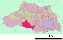

 Hannō
HannōCoordinates: 35°51′N 139°19′E / 35.85°N 139.317°ECoordinates: 35°51′N 139°19′E / 35.85°N 139.317°E Country Japan Region Kantō Prefecture Saitama Government – Mayor Seiichi Sawabe (since August 2001) Area – Total 134.60 km2 (52 sq mi) Population (April 1, 2011) – Total 82,683 – Density 614.29/km2 (1,591/sq mi) Time zone Japan Standard Time (UTC+9) City symbols - Tree Cryptomeria japonica - Flower Rhododendron - Bird Cettia diphone Phone number 042-973-2111 Address 1-1 Naniyanagi
357-8501Website [1] Hannō (飯能市 Hannō-shi) is a city in Saitama Prefecture, Japan.
As of April 1, 2011, the city has an estimated population of 82,683 and a population density of 614.29 per km². The total area is 134.60 km².
Hannō is mainly made up of urban and suburban areas, surrounded by mountains and rivers.
The city was founded on January 1, 1954.
On January 1, 2005 the village of Naguri, from Iruma District, was merged into Hannō.
Hanno Festival
- Hanno Festival, which held on November 3 to 5, since 1970, as known for festival in Saitama Prefecture[citation needed]。
Sister cities
The city of Brea, California in the United States is Hannō's official American Sister City.
Lagos de Moreno, Jalisco, Mexico
External links
- Official website (Japanese)
 Saitama Prefecture
Saitama (capital city) 
Cities - Ageo
- Asaka
- Chichibu
- Fujimi
- Fujimino
- Fukaya
- Gyōda
- Hannō
- Hanyū
- Hasuda
- Hidaka
- Higashi-Matsuyama
- Honjō
- Iruma
- Kasukabe
- Kawagoe
- Kawaguchi
- Kazo
- Kitamoto
- Koshigaya
- Kōnosu
- Kuki
- Kumagaya
- Misato
- Niiza
- Okegawa
- Saitama (capital)
- Sakado
- Satte
- Sayama
- Shiki
- Sōka
- Toda
- Tokorozawa
- Tsurugashima
- Wakō
- Warabi
- Yashio
- Yoshikawa
Districts Former districts Categories:- Cities in Saitama Prefecture
- Saitama geography stubs


Wikimedia Foundation. 2010.